Atm nearby ATM
United Kingdom
Atm nearby ATM
ATM
32 Hillwood Road, Birmingham Vereinigtes Königreich
contacts phone
:
+44
Latitude:
52.4303365
, Longitude:
-1.9839688
read more
nearest Atm
606 m
ATM
79-81 Taysfield Road, Birmingham
Atm
read more
1.002 km
ATM
202 Green Meadow Road, Birmingham
Atm
read more
1.03 km
ATM
2 Jiggins Lane, Birmingham
Atm
read more
1.276 km
ATM (Cashino Gaming Ltd)
157 Weoley Castle Road, Birmingham
Atm
read more
1.402 km
ATM
Barnes Hill, Birmingham
Atm
read more
1.406 km
Barclays ATM
Barnes Hill, Asda, Birmingham
Atm
read more
1.469 km
ATM
16-22, Illeybrook Square, Bartley Green, Birmingham
Atm
read more
1.569 km
ATM (TZ Stores)
249 Merritt's Brook Lane, Birmingham
Atm
read more
1.622 km
ATM
91 Sommerfield Road, Birmingham
Atm
read more
1.812 km
ATM
321 Sommerfield Road, Birmingham
Atm
read more
1.823 km
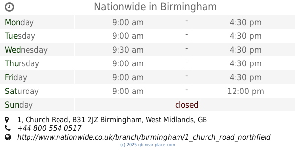
Nationwide
1 Church Road, Northfield, Birmingham
Atm
read more
1.823 km
Nationwide
1 Church Road, Birmingham
Atm
read more
1.905 km
ATM
Tenby Court, 32 Tugford Road, Birmingham
Atm
read more
1.943 km
ATM
798 Bristol Road South, Birmingham
Atm
read more
2.061 km
ATM (Babs Off Licence)
32 Norrington Road, Birmingham
Atm
read more
2.071 km
Sainsbury's ATM
Frankley Beeches Road, Birmingham
Atm
read more
2.287 km
ATM
293 Northfield Road, Birmingham
Atm
read more
2.325 km
ATM
187A Weoley Avenue, Birmingham
Atm
read more
2.327 km
ATM (Swinford News & Stores)
3 Swinford Road, Birmingham
Atm
read more
2.478 km
ATM (Quinton Stores)
25-27 Quinton Road West, Quinton, Birmingham
Atm
read more
2.551 km
ATM (Blanford Wines)
107 Blandford Road, Birmingham
Atm
read more
2.677 km
ATM
156 Quinton Road, Birmingham
Atm
read more
2.887 km
ATM (Select And Save Northfield)
78A Ingoldsby Road, Birmingham
Atm
read more
3.093 km
ATM
10A Northfield Road, Birmingham
Atm
read more
3.338 km
ATM
220-224 Wychall Road, Birmingham
Atm
read more
📑
all categories
Accounting
Administrative area level 1
Administrative area level 2
Airport
Amusement park
Aquarium
Art gallery
Atm
Bakery
Bank
Bar
Beauty salon
Bicycle store
Book store
Bowling alley
Bus station
Cafe
Campground
Car dealer
Car rental
Car repair
Car wash
Casino
Cemetery
Church
City hall
Clothing store
Colloquial area
Convenience store
Courthouse
Dentist
Department store
Doctor
Electrician
Electronics store
Embassy
Establishment
Finance
Fire station
Florist
Food
Funeral home
Furniture store
Gas station
General contractor
Grocery or supermarket
Gym
Hair care
Hardware store
Health
Hindu Temple
Home goods store
Hospital
Insurance agency
Jewelry store
Laundry
Lawyer
Library
Light rail station
Liquor store
Local government office
Locality
Locksmith
Lodging
Meal delivery
Meal takeaway
Mosque
Movie rental
Movie theater
Moving company
Museum
Natural feature
Neighborhood
Night club
Painter
Park
Parking
Pet store
Pharmacy
Physiotherapist
Place of worship
Plumber
Point of interest
Police
Political
Post office
Premise
Real estate agency
Restaurant
Roofing contractor
Route
Rv park, camping
School
Shoe store
Shopping mall
Spa
Stadium
Storage
Store
Subpremise
Subway station
Supermarket
Synagogue
Taxi stand
Train station
Transit station
Travel agency
University
Veterinary care
Zoo
administrative area level 3
administrative area level 4
sublocality level 1
↑