Atm nearby Twickenham Post Office ATM
United Kingdom
Atm nearby Twickenham Post Office ATM
Twickenham Post Office ATM
59 London Road, Twickenham Det Forenede Kongerige
contacts phone
:
+44
Latitude:
51.4485717
, Longitude:
-0.3295801
read more
nearest Atm
51 m
ATM (Outside Waitrose)
Twickenham
Atm
read more
84 m
ATM Outside Police Station
Twickenham
Atm
read more
105 m
ATM
70 London Road, Twickenham
Atm
read more
240 m
Barclays ATM
2 York Street, Twickenham
Atm
read more
285 m
Santander ATM
32 Church Street, Twickenham
Atm
read more
331 m
ATM
25 King Street, Twickenham
Atm
read more
331 m
ATM
12 Whitton Road, Twickenham
Atm
read more
360 m
Nationwide ATM
34 Heath Road, Twickenham
Atm
read more
361 m
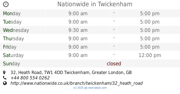
Nationwide
32 Heath Road, Twickenham
Atm
read more
386 m
Lloyds Bank ATM
19 Heath Road, Twickenham
Atm
read more
511 m
ATM
112 Heath Road, Twickenham
Atm
read more
672 m
ATM
166 Heath Road, Twickenham
Atm
read more
702 m
ATM
101 Whitton Road, Twickenham
Atm
read more
995 m
ATM
129-131 Saint Margarets Road, Twickenham
Atm
read more
1.52 km
ATM
Londis Supermarket, 372 Richmond Road, Twickenham
Atm
read more
1.676 km
ATM
260 Twickenham Road, Isleworth
Atm
read more
1.968 km
ATM (The Watermans Arms)
10 Water Lane, Richmond
Atm
read more
1.975 km
ATM
1 Hill Rise, Richmond
Atm
read more
2.007 km
ATM
224 Hampton Road, Twickenham
Atm
read more
2.278 km
Santander ATM
5 Sheen Road, Richmond
Atm
read more
2.311 km
Nationwide
3 The Square, Richmond
Atm
read more
2.341 km
ATM
58 Wellington Road, Hampton
Atm
read more
2.47 km
ATM
Richmond Railway Station, Kew Road, Richmond
Atm
read more
2.47 km
Barclays ATM
Richmond Station, 27G The Quadrant, Richmond
Atm
read more
2.537 km
Richmond Station ATM
Richmond
Atm
read more
📑
all categories
Accounting
Administrative area level 1
Administrative area level 2
Airport
Amusement park
Aquarium
Art gallery
Atm
Bakery
Bank
Bar
Beauty salon
Bicycle store
Book store
Bowling alley
Bus station
Cafe
Campground
Car dealer
Car rental
Car repair
Car wash
Casino
Cemetery
Church
City hall
Clothing store
Colloquial area
Convenience store
Courthouse
Dentist
Department store
Doctor
Electrician
Electronics store
Embassy
Establishment
Finance
Fire station
Florist
Food
Funeral home
Furniture store
Gas station
General contractor
Grocery or supermarket
Gym
Hair care
Hardware store
Health
Hindu Temple
Home goods store
Hospital
Insurance agency
Jewelry store
Laundry
Lawyer
Library
Light rail station
Liquor store
Local government office
Locality
Locksmith
Lodging
Meal delivery
Meal takeaway
Mosque
Movie rental
Movie theater
Moving company
Museum
Natural feature
Neighborhood
Night club
Painter
Park
Parking
Pet store
Pharmacy
Physiotherapist
Place of worship
Plumber
Point of interest
Police
Political
Post office
Premise
Real estate agency
Restaurant
Roofing contractor
Route
Rv park, camping
School
Shoe store
Shopping mall
Spa
Stadium
Storage
Store
Subpremise
Subway station
Supermarket
Synagogue
Taxi stand
Train station
Transit station
Travel agency
University
Veterinary care
Zoo
administrative area level 3
administrative area level 4
sublocality level 1
↑