Bakery nearby Hursts Bakery
Coronavirus disease (COVID-19) Situation
confirmed cases
24910387
deaths
232112
United Kingdom
Bakery nearby Hursts Bakery
Hursts Bakery
113 Mount Road, Birkenhead Reino Unido
contacts phone
:
+44
Latitude:
53.369894
, Longitude:
-3.027897
read more
nearest Bakery
653 m
Angels Cupcakes
M53, Wirral CH63 5
Bakery
read more
876 m
Sayers
742 Borough Road, Birkenhead
Bakery
read more
925 m
Hursts Bakery
220 Bebington Road, Birkenhead
Bakery
read more
1.075 km
Sayers
Unit 6/Rock Ferry Centre/Old Chester Rd, Birkenhead
Bakery
read more
1.272 km
Hursts Bakery
Unit 5 5, The Court House, Church Road, Birkenhead
Bakery
read more
1.764 km
B:ox Bakery
12 Christchurch Road, Prenton
Bakery
read more
2.008 km
Showpiece Cakes
New Chester Road, Birkenhead
Bakery
read more
2.107 km
Millie's Cookies, The Pyramids
6A West Mall The Pyramids Shopping Centre, Birkenhead
Bakery
read more
2.145 km
Millie's Cookies
6A West Mall, The Pyramids Shopping Centre, Birkenhead
Bakery
read more
2.159 km
Hursts Bakery
36-38, Grange Road West, Birkenhead
Bakery
read more
2.205 km
Hursts Bakery
30 Wellington Road, Birkenhead, Prenton
Bakery
read more
2.234 km
Sayers
22-24 Bebington Road, Birkenhead, Wirral
Bakery
read more
2.256 km
Poundbakery
239-241 Grange Road, Birkenhead
Bakery
read more
2.342 km
Hursts Bakery
116 Claughton Road, Birkenhead
Bakery
read more
2.636 km
The Popperie
2 Kindale Road, Prenton
Bakery
read more
2.646 km
Yummy Cakes By Sue
2 Alvega Close, Wirral
Bakery
read more
2.745 km
Patacake
33 Christleton Close, Wirral
Bakery
read more
2.788 km
Cameo Cakecraft
Unit 4, Park Entrance Business Centre, Vittoria Street, Birkenhead
Bakery
read more
2.803 km
Gillicious Cakes
3 Harlech Court, Wirral
Bakery
read more
2.929 km
Hursts Bakery
26 Cross Lane, Birkenhead
Bakery
read more
3.018 km
Cupcake Direct
5 The Ginnel, Wirral
Bakery
read more
3.079 km
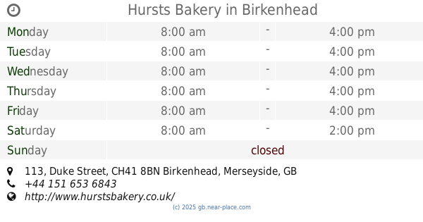
Hursts Bakery
113 Duke Street, Birkenhead
Bakery
read more
3.395 km
Hursts Bakery
16-18, Upton Road, Birkenhead
Bakery
read more
5.416 km
Sayers
19 Allport Lane, Wirral
Bakery
read more
6.53 km
Whitmore and White
124a Telegraph Road, Heswall
Bakery
read more
📑
all categories
Accounting
Administrative area level 1
Administrative area level 2
Airport
Amusement park
Aquarium
Art gallery
Atm
Bakery
Bank
Bar
Beauty salon
Bicycle store
Book store
Bowling alley
Bus station
Cafe
Campground
Car dealer
Car rental
Car repair
Car wash
Casino
Cemetery
Church
City hall
Clothing store
Colloquial area
Convenience store
Courthouse
Dentist
Department store
Doctor
Electrician
Electronics store
Embassy
Establishment
Finance
Fire station
Florist
Food
Funeral home
Furniture store
Gas station
General contractor
Grocery or supermarket
Gym
Hair care
Hardware store
Health
Hindu Temple
Home goods store
Hospital
Insurance agency
Jewelry store
Laundry
Lawyer
Library
Light rail station
Liquor store
Local government office
Locality
Locksmith
Lodging
Meal delivery
Meal takeaway
Mosque
Movie rental
Movie theater
Moving company
Museum
Natural feature
Neighborhood
Night club
Painter
Park
Parking
Pet store
Pharmacy
Physiotherapist
Place of worship
Plumber
Point of interest
Police
Political
Post office
Premise
Real estate agency
Restaurant
Roofing contractor
Route
Rv park, camping
School
Shoe store
Shopping mall
Spa
Stadium
Storage
Store
Subpremise
Subway station
Supermarket
Synagogue
Taxi stand
Train station
Transit station
Travel agency
University
Veterinary care
Zoo
administrative area level 3
administrative area level 4
sublocality level 1
↑