Bakery nearby Parry's Pantry
Coronavirus disease (COVID-19) Situation
confirmed cases
24910387
deaths
232112
United Kingdom
Bakery nearby Parry's Pantry
Parry's Pantry
84 Westbury Crescent, Oxford Reino Unido
contacts phone
:
+44
Latitude:
51.7292661
, Longitude:
-1.2218246
read more
nearest Bakery
671 m
Rebecca Chapman Cake Creation
7 Burgan Close, Oxford
Bakery
read more
1.056 km
Crystal Candy
Innovation House, 1A, John Smith Drive, Oxford
Bakery
read more
1.383 km
Le Bon Pain Bakery
Garsington Road, Oxford
Bakery
read more
1.713 km
Nash's Bakeries
108 Blackbird Leys Road, Oxford
Bakery
read more
1.778 km
Daudhar News
96-100 Horspath Road, Oxford
Bakery
read more
2.052 km
The Oxford Cake Co.
47 Henley Road, Sandford-on-Thames, Oxford
Bakery
read more
2.127 km
Simply Cake By Sam
14 Bulan Road, Oxford
Bakery
read more
2.196 km
All Cakes and Sizes
13 Berry Close, Oxford
Bakery
read more
2.501 km
Milleseuiwle
86 Cowley Road, Oxford
Bakery
read more
2.627 km
Wood Farm Bakery
21 Atkyns Road, Oxford
Bakery
read more
2.697 km
Rachel's
55 Saint Clement's Street, Oxford
Bakery
read more
3.29 km
Petit Gateau
High Street, Oxford
Bakery
read more
3.45 km
Fine Slice
23 High Street, Oxford
Bakery
read more
3.505 km
PAUL Oxford
138 High Street, Oxford
Bakery
read more
3.508 km
Ben's Cookies
108-109 Covered Market, Oxford
Bakery
read more
3.539 km
Krispy Kreme
Westgate Oxford, Castle Street, Oxford
Bakery
read more
3.539 km
The Cake Shop
123-127 Avenue 4, The Covered Market, Oxford
Bakery
read more
3.558 km
Nash's
24-25 The Market, Oxford
Bakery
read more
3.56 km
Cornish Bakehouse
The Clarendon Centre, 52 Cornmarket Street, Oxford
Bakery
read more
3.565 km
Krispy Kreme
10, The Clarendon Centre, 52 Cornmarket Street, Oxford
Bakery
read more
3.565 km
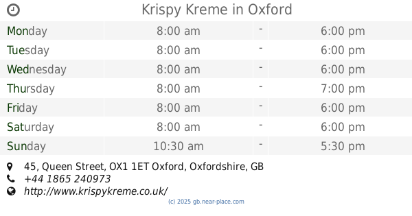
Krispy Kreme
45 Queen Street, Oxford
Bakery
read more
3.579 km
Luca & Alex Patisserie
Covered Market, Oxford
Bakery
read more
3.597 km
PAUL Oxford Westgate
Upper Ground Floor, Westgate Shopping Centre,, Oxford
Bakery
read more
4.25 km
Sticky Fingers Party Food, Oxford
15 Ingle Close, Headington
Bakery
read more
5.209 km
Sarah's Sweets
Linton Road, Oxford
Bakery
read more
📑
all categories
Accounting
Administrative area level 1
Administrative area level 2
Airport
Amusement park
Aquarium
Art gallery
Atm
Bakery
Bank
Bar
Beauty salon
Bicycle store
Book store
Bowling alley
Bus station
Cafe
Campground
Car dealer
Car rental
Car repair
Car wash
Casino
Cemetery
Church
City hall
Clothing store
Colloquial area
Convenience store
Courthouse
Dentist
Department store
Doctor
Electrician
Electronics store
Embassy
Establishment
Finance
Fire station
Florist
Food
Funeral home
Furniture store
Gas station
General contractor
Grocery or supermarket
Gym
Hair care
Hardware store
Health
Hindu Temple
Home goods store
Hospital
Insurance agency
Jewelry store
Laundry
Lawyer
Library
Light rail station
Liquor store
Local government office
Locality
Locksmith
Lodging
Meal delivery
Meal takeaway
Mosque
Movie rental
Movie theater
Moving company
Museum
Natural feature
Neighborhood
Night club
Painter
Park
Parking
Pet store
Pharmacy
Physiotherapist
Place of worship
Plumber
Point of interest
Police
Political
Post office
Premise
Real estate agency
Restaurant
Roofing contractor
Route
Rv park, camping
School
Shoe store
Shopping mall
Spa
Stadium
Storage
Store
Subpremise
Subway station
Supermarket
Synagogue
Taxi stand
Train station
Transit station
Travel agency
University
Veterinary care
Zoo
administrative area level 3
administrative area level 4
sublocality level 1
↑