Bakery nearby Ripa's Cakes
United Kingdom
Bakery nearby Ripa's Cakes
Ripa's Cakes
38B Walterton Road, London Vereinigtes Königreich
contacts phone
:
+44
Latitude:
51.5258104
, Longitude:
-0.2000506
read more
nearest Bakery
222 m
La Maison du Gateau
367 Harrow Road, London
Bakery
read more
305 m
Tregeser
203 Shirland Road, London
Bakery
read more
305 m
Bay Bakeries
203 Shirland Road, London
Bakery
read more
401 m
kado
376 Harrow Road, London
Bakery
read more
735 m
L'Étoile de Sous
79 Golborne Road, London
Bakery
read more
810 m
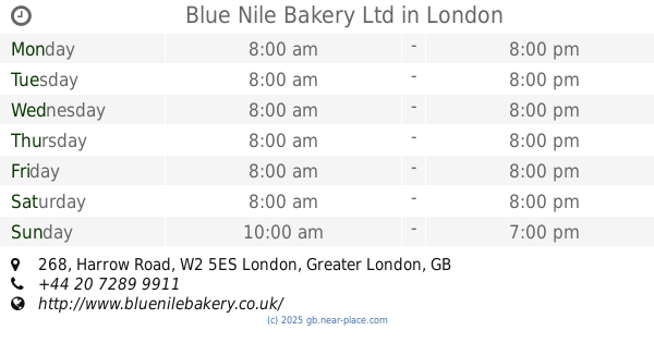
Blue Nile Bakery Ltd
268 Harrow Road, London
Bakery
read more
908 m
The Butter Bakery
219 Westbourne Park Road, London
Bakery
read more
1.154 km
Delicious Bakery
7 Kilburn Lane, London
Bakery
read more
1.165 km
Sweet Things
8 Blenheim Crescent, London
Bakery
read more
1.218 km
Ottolenghi Notting Hill
63 Ledbury Road, London
Bakery
read more
1.415 km
Baker & Spice
20 Clifton Rd, London
Bakery
read more
1.421 km
Patisserie Valerie
174-176 Queensway, London
Bakery
read more
1.539 km
Wenzel's the Bakers
106A Kilburn High Road, London
Bakery
read more
1.844 km
Paul Rhodes Bakery London
26 Notting Hill Gate, London
Bakery
read more
1.848 km
Paul Rhodes Bakery
26 Notting Hill Gate, London
Bakery
read more
1.848 km
Marsh & Parsons
26 Notting Hill Gate, London
Bakery
read more
1.897 km
PAUL Notting Hill Gate
61 Notting Hill Gate, London
Bakery
read more
1.898 km
Le Pain Quotidien
81-85 Notting Hill Gate, London
Bakery
read more
1.92 km
Soboro Bakery Paddington Station
Paddington Station, Praed Street, London
Bakery
read more
1.92 km
Dining Room
129 Bayswater Road, London
Bakery
read more
1.922 km
Aubaine Notting Hill
129 Bayswater Road, London
Bakery
read more
1.959 km
The Pasty Shop
146 Praed Street, London
Bakery
read more
2.117 km
Neo Cakes
20 Norfolk Square, London
Bakery
read more
2.149 km
GAIL's Bakery St Johns Wood
5 Circus Road, London
Bakery
read more
2.56 km
Millie's Cookies
1089A, Westfield London, Wood Lane, London
Bakery
read more
📑
all categories
Accounting
Administrative area level 1
Administrative area level 2
Airport
Amusement park
Aquarium
Art gallery
Atm
Bakery
Bank
Bar
Beauty salon
Bicycle store
Book store
Bowling alley
Bus station
Cafe
Campground
Car dealer
Car rental
Car repair
Car wash
Casino
Cemetery
Church
City hall
Clothing store
Colloquial area
Convenience store
Courthouse
Dentist
Department store
Doctor
Electrician
Electronics store
Embassy
Establishment
Finance
Fire station
Florist
Food
Funeral home
Furniture store
Gas station
General contractor
Grocery or supermarket
Gym
Hair care
Hardware store
Health
Hindu Temple
Home goods store
Hospital
Insurance agency
Jewelry store
Laundry
Lawyer
Library
Light rail station
Liquor store
Local government office
Locality
Locksmith
Lodging
Meal delivery
Meal takeaway
Mosque
Movie rental
Movie theater
Moving company
Museum
Natural feature
Neighborhood
Night club
Painter
Park
Parking
Pet store
Pharmacy
Physiotherapist
Place of worship
Plumber
Point of interest
Police
Political
Post office
Premise
Real estate agency
Restaurant
Roofing contractor
Route
Rv park, camping
School
Shoe store
Shopping mall
Spa
Stadium
Storage
Store
Subpremise
Subway station
Supermarket
Synagogue
Taxi stand
Train station
Transit station
Travel agency
University
Veterinary care
Zoo
administrative area level 3
administrative area level 4
sublocality level 1
↑