Bank nearby Bank Of India
Coronavirus disease (COVID-19) Situation
confirmed cases
24910387
deaths
232112
United Kingdom
Bank nearby Bank Of India
Bank Of India
182 Soho Road, Birmingham Det Forenede Kongerige
contacts phone
:
+44
Latitude:
52.5032975
, Longitude:
-1.933922
read more
nearest Bank
59 m
Lloyds banking
9 Grove Lane, Birmingham
Bank
read more
74 m
Lloyds Bank
162 Soho Road, Birmingham
Bank
read more
152 m
Bank Of Baroda
173-175 Soho Road, Birmingham
Bank
read more
254 m
Jamaica National UK Office
311 Soho Road, Birmingham
Bank
read more
275 m
State Bank of India (UK) Limited
1, 118 Soho Road, Birmingham
Bank
read more
342 m
Punjab National Bank International Ltd
290 Soho Road, Birmingham
Bank
read more
346 m
ICICI Bank
92-94 Soho Road, Birmingham
Bank
read more
410 m
Barclays Bank
351-359 Soho Road, Birmingham
Bank
read more
1.222 km
Grameen bangla
3 Barker Street, Birmingham
Bank
read more
1.391 km
KING DEREK POUND JOHNSON PALACE EST1978
Holly Grove, Heathfield Road, Birmingham
Bank
read more
2.294 km
HSBC
168 Warstone Lane, Birmingham
Bank
read more
2.304 km
TSB Bank
22a Great Hampton St, Birmingham
Bank
read more
2.304 km
TSB Bank
22a Great Hampton Street, Birmingham
Bank
read more
2.337 km
Barclays Bank
35 Frederick Street, Birmingham
Bank
read more
2.467 km
TSB Bank
293 Birchfield Road, Birmingham
Bank
read more
2.47 km
Barclays Bank
67 Cape Hill, Smethwick
Bank
read more
2.472 km
United Counties Bank
United Kingdom
Bank
read more
2.475 km
TSB Bank
63-65 Cape Hill, Smethwick
Bank
read more
2.483 km
NatWest Bank
22 Frederick Street, Birmingham
Bank
read more
2.7 km
The Trussell Trust Food Bank
Holy Trinity Church, Church Hill Street, Smethwick
Bank
read more
3.352 km
The Co-op Bank
118/120 Colmore Row, Birmingham
Bank
read more
3.497 km
Lloyds Bank
43 Temple Row, West Midlands, Birmingham
Bank
read more
3.621 km
Lloyds Bank
2 & 3, Caxton Gate, 36/38 New Street, Birmingham
Bank
read more
3.662 km
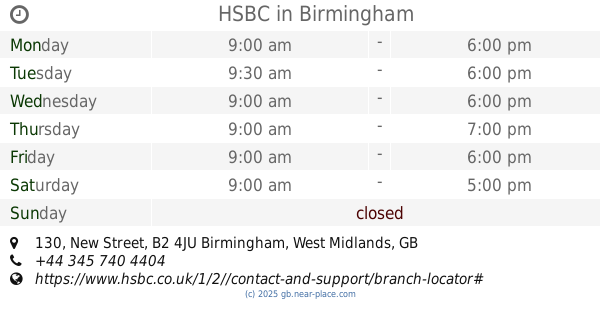
HSBC
130 New Street, Birmingham
Bank
read more
3.872 km
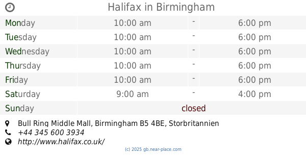
Halifax
Bull Ring Middle Mall, Birmingham
Bank
read more
📑
all categories
Accounting
Administrative area level 1
Administrative area level 2
Airport
Amusement park
Aquarium
Art gallery
Atm
Bakery
Bank
Bar
Beauty salon
Bicycle store
Book store
Bowling alley
Bus station
Cafe
Campground
Car dealer
Car rental
Car repair
Car wash
Casino
Cemetery
Church
City hall
Clothing store
Colloquial area
Convenience store
Courthouse
Dentist
Department store
Doctor
Electrician
Electronics store
Embassy
Establishment
Finance
Fire station
Florist
Food
Funeral home
Furniture store
Gas station
General contractor
Grocery or supermarket
Gym
Hair care
Hardware store
Health
Hindu Temple
Home goods store
Hospital
Insurance agency
Jewelry store
Laundry
Lawyer
Library
Light rail station
Liquor store
Local government office
Locality
Locksmith
Lodging
Meal delivery
Meal takeaway
Mosque
Movie rental
Movie theater
Moving company
Museum
Natural feature
Neighborhood
Night club
Painter
Park
Parking
Pet store
Pharmacy
Physiotherapist
Place of worship
Plumber
Point of interest
Police
Political
Post office
Premise
Real estate agency
Restaurant
Roofing contractor
Route
Rv park, camping
School
Shoe store
Shopping mall
Spa
Stadium
Storage
Store
Subpremise
Subway station
Supermarket
Synagogue
Taxi stand
Train station
Transit station
Travel agency
University
Veterinary care
Zoo
administrative area level 3
administrative area level 4
sublocality level 1
↑