Bank nearby Lloyds Bank
United Kingdom
Bank nearby Lloyds Bank
Lloyds Bank
153 Weoley Castle Road, Birmingham Vereinigtes Königreich
contacts phone
:
+44
Latitude:
52.4382973
, Longitude:
-1.9702134
read more
nearest Bank
1.358 km
An Nhien house
55 Wheats Avenue, Birmingham
Bank
read more
2.534 km
Barclays Bank
766 Bristol Road South, Birmingham
Bank
read more
2.557 km
HSBC
770-772 Bristol Road South, West Midlands, Birmingham
Bank
read more
2.597 km
Halifax
786 Bristol Road South, Birmingham
Bank
read more
2.617 km
Lloyds Bank
798 Bristol Road South, Birmingham
Bank
read more
2.644 km
NatWest Bank
817 Bristol Road South, Birmingham
Bank
read more
2.672 km
Santander
High Street, Birmingham
Bank
read more
2.714 km
NatWest
166 High Street, Birmingham
Bank
read more
2.759 km
Lloyds Bank
125 High Street, Harborne, Birmingham
Bank
read more
2.764 km
HSBC
148 High Street, Birmingham
Bank
read more
2.816 km
Purpose Care Services Ltd
30 Station Road, Birmingham
Bank
read more
2.955 km
Barclays Bank
R23, Birmingham
Bank
read more
2.966 km
Barclays Bank
66-68 High Street, Birmingham
Bank
read more
3.031 km
Halifax
46 High Street, Birmingham
Bank
read more
3.175 km
Santander University Branch (no counter)
101 Edgbaston Park Road, Birmingham
Bank
read more
3.328 km
Coventry Building Society Birmingham, Quinton
516 Hagley Road West, Birmingham
Bank
read more
3.756 km
Lloyds Bank
1846 Pershore Road, Birmingham
Bank
read more
3.904 km
Cef
Sovereign Road, Birmingham
Bank
read more
3.926 km
Halifax
580-582 Bearwood Road, Smethwick
Bank
read more
4.808 km
NatWest
30 Harborne Road, Birmingham
Bank
read more
6.593 km
The Co-op Bank
118/120 Colmore Row, Birmingham
Bank
read more
6.677 km
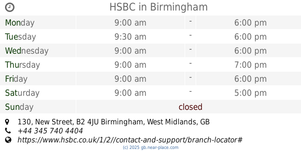
HSBC
130 New Street, Birmingham
Bank
read more
6.682 km
Lloyds Bank
2 & 3, Caxton Gate, 36/38 New Street, Birmingham
Bank
read more
6.834 km
Lloyds Bank
43 Temple Row, West Midlands, Birmingham
Bank
read more
6.894 km
Halifax
26-28 Colmore Row, Birmingham
Bank
read more
📑
all categories
Accounting
Administrative area level 1
Administrative area level 2
Airport
Amusement park
Aquarium
Art gallery
Atm
Bakery
Bank
Bar
Beauty salon
Bicycle store
Book store
Bowling alley
Bus station
Cafe
Campground
Car dealer
Car rental
Car repair
Car wash
Casino
Cemetery
Church
City hall
Clothing store
Colloquial area
Convenience store
Courthouse
Dentist
Department store
Doctor
Electrician
Electronics store
Embassy
Establishment
Finance
Fire station
Florist
Food
Funeral home
Furniture store
Gas station
General contractor
Grocery or supermarket
Gym
Hair care
Hardware store
Health
Hindu Temple
Home goods store
Hospital
Insurance agency
Jewelry store
Laundry
Lawyer
Library
Light rail station
Liquor store
Local government office
Locality
Locksmith
Lodging
Meal delivery
Meal takeaway
Mosque
Movie rental
Movie theater
Moving company
Museum
Natural feature
Neighborhood
Night club
Painter
Park
Parking
Pet store
Pharmacy
Physiotherapist
Place of worship
Plumber
Point of interest
Police
Political
Post office
Premise
Real estate agency
Restaurant
Roofing contractor
Route
Rv park, camping
School
Shoe store
Shopping mall
Spa
Stadium
Storage
Store
Subpremise
Subway station
Supermarket
Synagogue
Taxi stand
Train station
Transit station
Travel agency
University
Veterinary care
Zoo
administrative area level 3
administrative area level 4
sublocality level 1
↑