Bank nearby NatWest
United Kingdom
Bank nearby NatWest
NatWest
93 Greendale Road, Birkenhead, Wirral United Kingdom
contacts phone
:
+44
Latitude:
53.3490318
, Longitude:
-2.997093
read more
nearest Bank
2.254 km
Barclays Bank
The Cross, Bromborough, Wirral
Bank
read more
2.266 km
HSBC
58 Bromborough Village Road, Wirral
Bank
read more
2.333 km
Lloyds Bank
15-19 Allport Lane, Wirral
Bank
read more
4.172 km
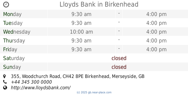
Lloyds Bank
355 Woodchurch Road, Prenton, Wirral
Bank
read more
4.172 km
Lloyds Bank
355 Woodchurch Road, Wirral
Bank
read more
4.766 km
Lloyds Bank
1 Borough Road, Birkenhead
Bank
read more
4.85 km
HSBC
Pyramids Shopping Centre, 31 Grange Road, Birkenhead
Bank
read more
4.862 km
Santander
SU32, Pyramids Shopping Centre, 31 Grange Road, Birkenhead
Bank
read more
4.862 km
Santander
Pyramids Shopping Centre, 31 Borough Road, Birkenhead
Bank
read more
4.896 km
Santander
Grange Rd, Birkenhead
Bank
read more
4.909 km
That's Entertainment
12 Princes Pavement, Birkenhead
Bank
read more
4.934 km
Barclays Bank
184, 182 Grange Road, Birkenhead
Bank
read more
4.949 km
Halifax
210 Grange Rd, Birkenhead
Bank
read more
4.959 km
Yorkshire Bank
2 Princes Pavement, The Grange Shopping Centre, Birkenhead
Bank
read more
4.994 km
HSBC
31 Grange Road, Birkenhead
Bank
read more
5.021 km
NatWest Bank
Charing Cross Hotel, 2 Grange Rd W, Birkenhead
Bank
read more
5.021 km
NatWest Bank
Charing Cross Hotel, 2 Grange Road West, Birkenhead
Bank
read more
5.124 km
RBS
34 Hamilton Square, Birkenhead, Liverpool
Bank
read more
5.62 km
C I C
16 Carnatic Road, Liverpool
Bank
read more
6.266 km
Barclays
48-50 Lord Street, Liverpool
Bank
read more
6.32 km
The Co-operative Bank
1-3 Parker Street, Liverpool
Bank
read more
6.429 km
H S B C
14 Castle Street, Liverpool
Bank
read more
6.71 km
TSB Bank
6 Speke Road, Garston, Liverpool
Bank
read more
14.174 km
TSB Bank
101 South Road, Waterloo, Liverpool
Bank
read more
16.503 km
Santander
4 Saint Chad's Drive, Liverpool
Bank
read more
📑
all categories
Accounting
Administrative area level 1
Administrative area level 2
Airport
Amusement park
Aquarium
Art gallery
Atm
Bakery
Bank
Bar
Beauty salon
Bicycle store
Book store
Bowling alley
Bus station
Cafe
Campground
Car dealer
Car rental
Car repair
Car wash
Casino
Cemetery
Church
City hall
Clothing store
Colloquial area
Convenience store
Courthouse
Dentist
Department store
Doctor
Electrician
Electronics store
Embassy
Establishment
Finance
Fire station
Florist
Food
Funeral home
Furniture store
Gas station
General contractor
Grocery or supermarket
Gym
Hair care
Hardware store
Health
Hindu Temple
Home goods store
Hospital
Insurance agency
Jewelry store
Laundry
Lawyer
Library
Light rail station
Liquor store
Local government office
Locality
Locksmith
Lodging
Meal delivery
Meal takeaway
Mosque
Movie rental
Movie theater
Moving company
Museum
Natural feature
Neighborhood
Night club
Painter
Park
Parking
Pet store
Pharmacy
Physiotherapist
Place of worship
Plumber
Point of interest
Police
Political
Post office
Premise
Real estate agency
Restaurant
Roofing contractor
Route
Rv park, camping
School
Shoe store
Shopping mall
Spa
Stadium
Storage
Store
Subpremise
Subway station
Supermarket
Synagogue
Taxi stand
Train station
Transit station
Travel agency
University
Veterinary care
Zoo
administrative area level 3
administrative area level 4
sublocality level 1
↑