Bank nearby RBS Data Centre
Coronavirus disease (COVID-19) Situation
confirmed cases
24910387
deaths
232112
United Kingdom
Bank nearby RBS Data Centre
RBS Data Centre
Pritchard Drive, Kegworth, Derby United Kingdom
contacts phone
:
+44
Latitude:
52.8389006
, Longitude:
-1.2865911
read more
nearest Bank
6.566 km
Lloyds Bank
8 Tamworth Road, Long Eaton, Nottingham
Bank
read more
6.568 km
Santander
79 High Street, Long Eaton, Nottingham
Bank
read more
6.698 km
Halifax
24 Market Place, Long Eaton, Nottingham
Bank
read more
10.811 km
Lloyds Bank
The Square, 3 High Road, Beeston, Nottingham
Bank
read more
14.261 km
Handelsbanken Derby
4 Pinnacle Way, Derby
Bank
read more
14.572 km
Lloyds Bank
59 Bracebridge Drive, Nottingham
Bank
read more
14.835 km
Lloyds Bank
Market Place, Ilkeston
Bank
read more
14.88 km
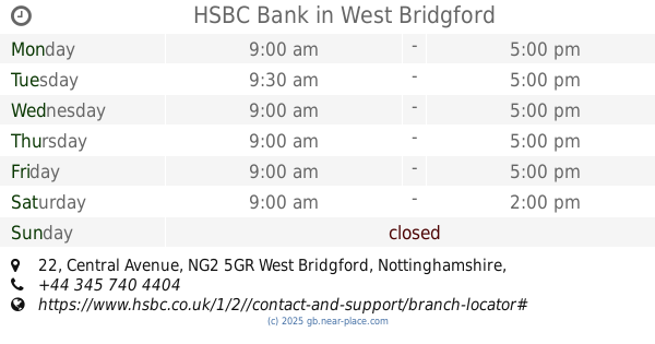
HSBC Bank
22 Central Avenue, West Bridgford, Nottingham
Bank
read more
14.907 km
Barclays Bank
1 Tudor Square, West Bridgford, Nottingham
Bank
read more
14.981 km
ATM (Bt Kiosk Nr Trent Bridge)
Radcliffe Road, West Bridgford, Notts
Bank
read more
15.011 km
NatWest Bank
42 Bath Street, Ilkeston
Bank
read more
15.39 km
Handelsbanken Nottingham Ropewalk
Ground Floor, 22a The Ropewalk, Nottingham
Bank
read more
15.453 km
Lloyds Bank Commercial Finance Ltd
Butt Dyke House, 33 Park Row, Nottingham
Bank
read more
15.528 km
Santander
93-95 Saint Peters Street, Derby
Bank
read more
15.556 km
RBS
13 Derby Road, Nottingham
Bank
read more
15.588 km
NatWest
58 Saint Peters Street, Derby
Bank
read more
15.597 km
Halifax
39 East Street, Derby
Bank
read more
15.614 km
Virgin Money Notthingham
4 Beastmarket Hill, Nottingham
Bank
read more
15.701 km
HSBC
1 St Peters St, Derby
Bank
read more
15.715 km
Coventry Building Society
1-2 Cheapside, Nottingham
Bank
read more
15.733 km
Virgin Money Derby
25 Cornmarket, Derby
Bank
read more
15.749 km
Barclays Bank
Barclays Business Centre, Sir Frank Whittle Road, Derby
Bank
read more
15.801 km
RBS
41 Cornmarket, Derby
Bank
read more
16.184 km
4Finance limited
Basinghall 40, rue de, London
Bank
read more
19.734 km
TSB Bank
4 Victoria Road, Netherfield, Nottingham
Bank
read more
📑
all categories
Accounting
Administrative area level 1
Administrative area level 2
Airport
Amusement park
Aquarium
Art gallery
Atm
Bakery
Bank
Bar
Beauty salon
Bicycle store
Book store
Bowling alley
Bus station
Cafe
Campground
Car dealer
Car rental
Car repair
Car wash
Casino
Cemetery
Church
City hall
Clothing store
Colloquial area
Convenience store
Courthouse
Dentist
Department store
Doctor
Electrician
Electronics store
Embassy
Establishment
Finance
Fire station
Florist
Food
Funeral home
Furniture store
Gas station
General contractor
Grocery or supermarket
Gym
Hair care
Hardware store
Health
Hindu Temple
Home goods store
Hospital
Insurance agency
Jewelry store
Laundry
Lawyer
Library
Light rail station
Liquor store
Local government office
Locality
Locksmith
Lodging
Meal delivery
Meal takeaway
Mosque
Movie rental
Movie theater
Moving company
Museum
Natural feature
Neighborhood
Night club
Painter
Park
Parking
Pet store
Pharmacy
Physiotherapist
Place of worship
Plumber
Point of interest
Police
Political
Post office
Premise
Real estate agency
Restaurant
Roofing contractor
Route
Rv park, camping
School
Shoe store
Shopping mall
Spa
Stadium
Storage
Store
Subpremise
Subway station
Supermarket
Synagogue
Taxi stand
Train station
Transit station
Travel agency
University
Veterinary care
Zoo
administrative area level 3
administrative area level 4
sublocality level 1
↑