Bar nearby Beefeater Coach & Horses
United Kingdom
Bar nearby Beefeater Coach & Horses
Beefeater Coach & Horses
Newport Road, CF3 2UQ, Castleton, Newport, GB Reino Unido
contacts phone
:
+44 1633 680070
website:
www.beefeater.co.uk
Latitude:
51.5464533
, Longitude:
-3.0781002
larger map & directions
read more
nearest Bar
1.563 km
Cefn Mably Arms
Michaelston-y-Fedw, Cardiff
Bar
read more
1.717 km
The Masons Arms
10 Saint Mellons Road, Marshfield, Cardiff
Bar
read more
1.987 km
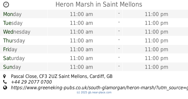
Heron Marsh
Pascal Close, Saint Mellons, Cardiff
Bar
read more
1.993 km
The Heron Marsh
Vaendre Close, Cardiff
Bar
read more
2.224 km
Y Maerun
140 Marshfield Road, Marshfield, Cardiff
Bar
read more
2.873 km
The Willows Pub
Willowbrook Drive, Saint Mellons, Cardiff
Bar
read more
3.245 km
The Dragonfly
Lakeside Drive, Coedkernew, Newport
Bar
read more
3.252 km
The Dragonfly
Lakeside Drive, Newport
Bar
read more
3.286 km
Bluebell Inn
Newport Rd, Cardiff
Bar
read more
3.296 km
Holiday Inn Express Newport
Lakeside Drive, Duffryn, Newport
Bar
read more
3.308 km
COACH HOUSE
Tyr Winch Road, Saint Mellons, Cardiff
Bar
read more
3.372 km
Poachers Arms
Church Lane, Llanrumney, Cardiff
Bar
read more
3.481 km
Fox & Hounds
Chapel Row, Cardiff
Bar
read more
3.689 km
Six Bells Inn
Broadstreet Common, Peterstone
Bar
read more
3.733 km
Ruperra Arms
Caerphilly Road, Bassaleg, Newport
Bar
read more
3.795 km
The Friendly Fox
33 Caerphilly Rd, Bassaleg, Newport
Bar
read more
4.008 km
The Duffryn Arms
Duffryn Drive, Duffryn, Newport
Bar
read more
4.021 km
Newbridge
Abergele Road, Rumney, Cardiff
Bar
read more
4.155 km
Tredegar Arms
4 Caerphilly Road, Bassaleg, Newport
Bar
read more
4.608 km
The Village Inn
Croescadarn Road, Cardiff
Bar
read more
5.182 km
Tiny Rebel Brewing
Wern Industrial Estate, Chartist Drive, Rogerstone, Newport
Bar
read more
5.4 km
Gaer Park Club & Institute
113 Bassaleg Road, Newport
Bar
read more
5.565 km
Spice Island
777/779 Newport Road, Cardiff
Bar
read more
5.744 km
Harvester Coed-Y-Gores
Circle Way East, Llanedeyrn, Cardiff
Bar
read more
6.384 km
Rumney Conservative Club
633 Newport Road, Rumney, Cardiff
Bar
read more
📑
all categories
Accounting
Administrative area level 1
Administrative area level 2
Airport
Amusement park
Aquarium
Art gallery
Atm
Bakery
Bank
Bar
Beauty salon
Bicycle store
Book store
Bowling alley
Bus station
Cafe
Campground
Car dealer
Car rental
Car repair
Car wash
Casino
Cemetery
Church
City hall
Clothing store
Colloquial area
Convenience store
Courthouse
Dentist
Department store
Doctor
Electrician
Electronics store
Embassy
Establishment
Finance
Fire station
Florist
Food
Funeral home
Furniture store
Gas station
General contractor
Grocery or supermarket
Gym
Hair care
Hardware store
Health
Hindu Temple
Home goods store
Hospital
Insurance agency
Jewelry store
Laundry
Lawyer
Library
Light rail station
Liquor store
Local government office
Locality
Locksmith
Lodging
Meal delivery
Meal takeaway
Mosque
Movie rental
Movie theater
Moving company
Museum
Natural feature
Neighborhood
Night club
Painter
Park
Parking
Pet store
Pharmacy
Physiotherapist
Place of worship
Plumber
Point of interest
Police
Political
Post office
Premise
Real estate agency
Restaurant
Roofing contractor
Route
Rv park, camping
School
Shoe store
Shopping mall
Spa
Stadium
Storage
Store
Subpremise
Subway station
Supermarket
Synagogue
Taxi stand
Train station
Transit station
Travel agency
University
Veterinary care
Zoo
administrative area level 3
administrative area level 4
sublocality level 1
↑