Bar nearby Fairwater
United Kingdom
Bar nearby Fairwater
Fairwater
Saint Fagans Road, CF5 3AH, Cardiff, Cardiff, GB United Kingdom
contacts phone
:
+44 29 2033 3049
website:
www.sabrain.com
Latitude:
51.4892882
, Longitude:
-3.2405684
larger map & directions
read more
nearest Bar
797 m
The Coach House
7 Station Terrace, Cardiff
Bar
read more
826 m
The Railway Inn
144 Ely Road, Cardiff
Bar
read more
903 m
Gloden Crown Fish Bar
69A Grand Avenue, Cardiff
Bar
read more
998 m
RAFA CLUB
Riverside Terrace, Cardiff
Bar
read more
1.068 km
Fairwater Conservative Club
Fairwater Conservative Club 2BY,, 61 Ely Road, Cardiff
Bar
read more
1.452 km
Heathcock Cardiff
A4119, Cardiff
Bar
read more
1.47 km
The Heathcock
58-60 Bridge St, Cardiff
Bar
read more
1.47 km
The Heathcock
The Heathcock, 58-60 Bridge Street, Cardiff
Bar
read more
1.511 km
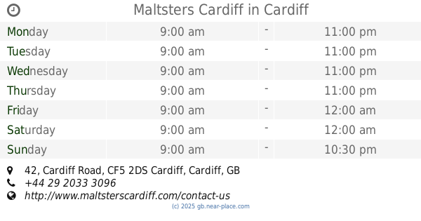
Maltsters Cardiff
42 Cardiff Road, Cardiff
Bar
read more
1.538 km
Black Lion
The Black Lion, 49 Cardiff Road, Cardiff
Bar
read more
1.612 km
Butchers Arms
16 High Street, Cardiff
Bar
read more
1.639 km
The Radyr Court
Rachel Close, Cardiff
Bar
read more
1.779 km
Star Of Wales
438 Cowbridge Road East, Cardiff
Bar
read more
1.83 km
Victoria Park
422 Cowbridge Road East, Cardiff
Bar
read more
1.834 km
Victoria Park Pub
422 Cowbridge Road East, Cardiff
Bar
read more
1.834 km
Victoria Park Pub
414 Cowbridge Road East, Cardiff
Bar
read more
1.841 km
Public Bar Skittle Alley
United Kingdom
Bar
read more
1.844 km
Pineapple Inn
39 Station Road, Cardiff
Bar
read more
1.907 km
The Plymouth Arms
Saint Fagans, Cardiff
Bar
read more
2.04 km
Clive Arms
360 Cowbridge Road East, Cardiff
Bar
read more
2.286 km
The Master Gunner
61 Gabalfa Avenue, Cardiff
Bar
read more
2.849 km
The Canton Cross Vaults
1 Leckwith Road, Cardiff
Bar
read more
2.967 km
Three Elms
Merthyr Road, Cardiff
Bar
read more
3.014 km
The Plough
1 Merthyr Road, Cardiff
Bar
read more
3.551 km
Burges Bar
Culverhouse, Copthorne Way, Cardiff
Bar
read more
📑
all categories
Accounting
Administrative area level 1
Administrative area level 2
Airport
Amusement park
Aquarium
Art gallery
Atm
Bakery
Bank
Bar
Beauty salon
Bicycle store
Book store
Bowling alley
Bus station
Cafe
Campground
Car dealer
Car rental
Car repair
Car wash
Casino
Cemetery
Church
City hall
Clothing store
Colloquial area
Convenience store
Courthouse
Dentist
Department store
Doctor
Electrician
Electronics store
Embassy
Establishment
Finance
Fire station
Florist
Food
Funeral home
Furniture store
Gas station
General contractor
Grocery or supermarket
Gym
Hair care
Hardware store
Health
Hindu Temple
Home goods store
Hospital
Insurance agency
Jewelry store
Laundry
Lawyer
Library
Light rail station
Liquor store
Local government office
Locality
Locksmith
Lodging
Meal delivery
Meal takeaway
Mosque
Movie rental
Movie theater
Moving company
Museum
Natural feature
Neighborhood
Night club
Painter
Park
Parking
Pet store
Pharmacy
Physiotherapist
Place of worship
Plumber
Point of interest
Police
Political
Post office
Premise
Real estate agency
Restaurant
Roofing contractor
Route
Rv park, camping
School
Shoe store
Shopping mall
Spa
Stadium
Storage
Store
Subpremise
Subway station
Supermarket
Synagogue
Taxi stand
Train station
Transit station
Travel agency
University
Veterinary care
Zoo
administrative area level 3
administrative area level 4
sublocality level 1
↑