Bar nearby Holiday Inn Brentwood M25, Jct.28
Coronavirus disease (COVID-19) Situation
confirmed cases
24910387
deaths
232112
United Kingdom
Bar nearby Holiday Inn Brentwood M25, Jct.28
Holiday Inn Brentwood M25, Jct.28
Brook Street, Brentwood United Kingdom
contacts phone
:
+44
Latitude:
51.611135
, Longitude:
0.269326
read more
nearest Bar
4.024 km
Chough
18 Eastham Crescent, Brentwood
Bar
read more
9.559 km
Miller & Carter Chigwell
Manor Road, Abridge, Romford
Bar
read more
10.375 km
The Two Brewers
57 Lambourne Road, Chigwell
Bar
read more
10.451 km
The Blue Boar
39 High Street, Billericay
Bar
read more
12.203 km
Brewers Fayre Chequers Corner
2 New Road, Dagenham
Bar
read more
12.682 km
Plough & Tractor
186 Great Knightleys, Basildon
Bar
read more
13.232 km
Lekki Lounge
443 Porters Avenue, Dagenham
Bar
read more
13.57 km
Holiday Inn Basildon
Festival Leisure Park, Waterfront Walk, Basildon
Bar
read more
13.578 km
Melrose bar
Time Square, Basildon
Bar
read more
14.414 km
Nyana
452 Cranbrook Road, Ilford
Bar
read more
15.207 km
Beefeater Haywain
High Road, Fobbing, Stanford-le-Hope
Bar
read more
17.2 km
The Wheatsheaf
70 The Green, Writtle, Chelmsford
Bar
read more
17.942 km
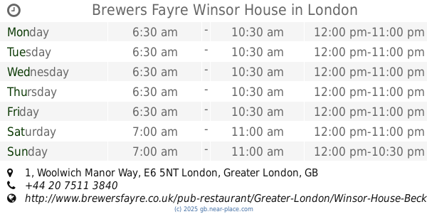
Brewers Fayre Winsor House
1 Woolwich Manor Way, London
Bar
read more
19.023 km
Star & Garter
159 Moulsham Street, Chelmsford
Bar
read more
19.099 km
The Moulsham Tap
53 Moulsham Street, Chelmsford
Bar
read more
19.154 km
Maisons Bar
50 Moulsham Street, Chelmsford
Bar
read more
19.401 km
The County Hotel
29 Rainsford Road, Chelmsford
Bar
read more
19.467 km
The Mitre
United Kingdom
Bar
read more
19.477 km
The Castle Tavern
179 Powis Street, London
Bar
read more
19.504 km
Barista
44-45 Dukes St, Chelmsford
Bar
read more
19.589 km
The Golden Fleece
84 Duke Street, Chelmsford
Bar
read more
19.648 km
Jindal's Bar & Lounge
United Kingdom
Bar
read more
19.686 km
The White Horse Pub
25 Townfield Street, Chelmsford
Bar
read more
19.831 km
The Wheatsheaf
28 New Street, Chelmsford
Bar
read more
20.257 km
The Oddfellows Arms
195 Springfield Road, Chelmsford
Bar
read more
📑
all categories
Accounting
Administrative area level 1
Administrative area level 2
Airport
Amusement park
Aquarium
Art gallery
Atm
Bakery
Bank
Bar
Beauty salon
Bicycle store
Book store
Bowling alley
Bus station
Cafe
Campground
Car dealer
Car rental
Car repair
Car wash
Casino
Cemetery
Church
City hall
Clothing store
Colloquial area
Convenience store
Courthouse
Dentist
Department store
Doctor
Electrician
Electronics store
Embassy
Establishment
Finance
Fire station
Florist
Food
Funeral home
Furniture store
Gas station
General contractor
Grocery or supermarket
Gym
Hair care
Hardware store
Health
Hindu Temple
Home goods store
Hospital
Insurance agency
Jewelry store
Laundry
Lawyer
Library
Light rail station
Liquor store
Local government office
Locality
Locksmith
Lodging
Meal delivery
Meal takeaway
Mosque
Movie rental
Movie theater
Moving company
Museum
Natural feature
Neighborhood
Night club
Painter
Park
Parking
Pet store
Pharmacy
Physiotherapist
Place of worship
Plumber
Point of interest
Police
Political
Post office
Premise
Real estate agency
Restaurant
Roofing contractor
Route
Rv park, camping
School
Shoe store
Shopping mall
Spa
Stadium
Storage
Store
Subpremise
Subway station
Supermarket
Synagogue
Taxi stand
Train station
Transit station
Travel agency
University
Veterinary care
Zoo
administrative area level 3
administrative area level 4
sublocality level 1
↑