Bar nearby Otter
United Kingdom
Bar nearby Otter
Otter
Bridge Street, Newbridge Det Forenede Kongerige
contacts phone
:
+44
Latitude:
51.6622656
, Longitude:
-3.1399064
read more
nearest Bar
949 m
The Red Lion
27 Bryngwyn Road, Newbridge, Newport
Bar
read more
1.33 km
Crown Inn
3 Dan-Y-Rhiw Terrace, Abercarn, Newport
Bar
read more
1.641 km
T L C Cafe
76 Elm Court, Newbridge, Newport
Bar
read more
1.658 km
Commercial Inn
3 High Street, Abercarn, Newport
Bar
read more
1.773 km
Cwtchers
45-47 High Street, Newbridge, Newport
Bar
read more
2.001 km
The RHYSWG
1, Commercial Road, Abercarn
Bar
read more
2.004 km
The NEW INN
1, Commercial Road, Abercarn
Bar
read more
2.803 km
Hafodyrynys Inn
Hafodyrynys, Newport
Bar
read more
2.925 km
The New Forge
Brynhoward Terrace, Oakdale, Blackwood
Bar
read more
2.994 km
The Cwmcarn Hotel
Newport Road, Cwmcarn, Caerphilly
Bar
read more
3.226 km
The Church Inn
Cwmfelinfach, Blackwood
Bar
read more
3.293 km
The Cross Oak Inn
Cross Oak Inn, Cross Oak Cottages, Blackwood
Bar
read more
3.447 km
Bistro 8
Park Terrace, Woodfieldside
Bar
read more
3.512 km
The Rock & Fountain Inn
Saint David's Avenue, Blackwood
Bar
read more
3.821 km
Porters Blackwood
142 High Street, Blackwood
Bar
read more
3.855 km
The New Foresters
110 High Street, Blackwood
Bar
read more
4.093 km
The Halfway House
Upper Gelligroes, Blackwood
Bar
read more
4.577 km
Cross Keys Hotel
High Street, Newport
Bar
read more
4.665 km
Cross Keys Silver Band
A467 Crosskeys Newport, Monmouthshire NP11 7
Bar
read more
4.707 km
Crown Pub
54 Pentwyn Road, Blackwood
Bar
read more
4.916 km
The Jameses
15 High Street, Argoed, Blackwood
Bar
read more
5.007 km
Black Prince
Newport
Bar
read more
5.098 km
Central Club & Institute
93-95 Cefn Fforest Avenue, Blackwood
Bar
read more
5.572 km
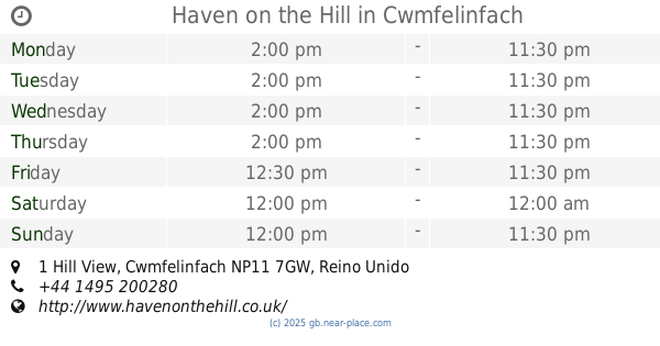
Haven on the Hill
1 Hill View, Cwmfelinfach
Bar
read more
6.02 km
The Church Inn
Bedwellty, Blackwood
Bar
read more
📑
all categories
Accounting
Administrative area level 1
Administrative area level 2
Airport
Amusement park
Aquarium
Art gallery
Atm
Bakery
Bank
Bar
Beauty salon
Bicycle store
Book store
Bowling alley
Bus station
Cafe
Campground
Car dealer
Car rental
Car repair
Car wash
Casino
Cemetery
Church
City hall
Clothing store
Colloquial area
Convenience store
Courthouse
Dentist
Department store
Doctor
Electrician
Electronics store
Embassy
Establishment
Finance
Fire station
Florist
Food
Funeral home
Furniture store
Gas station
General contractor
Grocery or supermarket
Gym
Hair care
Hardware store
Health
Hindu Temple
Home goods store
Hospital
Insurance agency
Jewelry store
Laundry
Lawyer
Library
Light rail station
Liquor store
Local government office
Locality
Locksmith
Lodging
Meal delivery
Meal takeaway
Mosque
Movie rental
Movie theater
Moving company
Museum
Natural feature
Neighborhood
Night club
Painter
Park
Parking
Pet store
Pharmacy
Physiotherapist
Place of worship
Plumber
Point of interest
Police
Political
Post office
Premise
Real estate agency
Restaurant
Roofing contractor
Route
Rv park, camping
School
Shoe store
Shopping mall
Spa
Stadium
Storage
Store
Subpremise
Subway station
Supermarket
Synagogue
Taxi stand
Train station
Transit station
Travel agency
University
Veterinary care
Zoo
administrative area level 3
administrative area level 4
sublocality level 1
↑