Bar nearby The Grapes
United Kingdom
Bar nearby The Grapes
The Grapes
22 Green Lane, Thornton, Liverpool Reino Unido
contacts phone
:
+44
Latitude:
53.5014254
, Longitude:
-3.0027421
read more
nearest Bar
155 m
Nags Head
Green Lane, Crosby, Liverpool
Bar
read more
1.735 km
Blues Bar
21 Moor Lane, Crosby, Liverpool
Bar
read more
1.812 km
The Cooksons Bridge
Bootle
Bar
read more
1.813 km
Cookson Bridge
82 Gorsey Lane, Bootle, Liverpool
Bar
read more
1.828 km
The George Hotel
1 Moor Lane, Liverpool
Bar
read more
1.832 km
The Village
2-4 Moor Lane, Liverpool
Bar
read more
1.849 km
Tides Bar
Liverpool Road, Crosby, Liverpool
Bar
read more
1.874 km
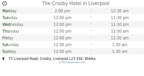
The Crosby Hotel
75 Liverpool Road, Crosby, Liverpool
Bar
read more
1.883 km
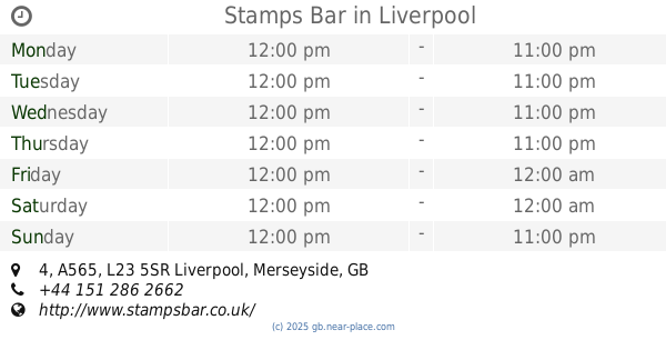
Stamps Bar
Crown Buildings, 4 A565, Liverpool
Bar
read more
1.927 km
Birkey
35 Cooks Road, Blundellsands & Crosby, Liverpool
Bar
read more
1.934 km
Liverpool Pigeon Micro Pub
14 Endbutt Lane, Waterloo, Liverpool
Bar
read more
1.97 km
Pioneer Bar and Brasserie
107 Liverpool Road, Crosby, Liverpool
Bar
read more
1.973 km
Endbutt
63-65 Endbutt Lane, Liverpool
Bar
read more
2.037 km
Corkscrew Wine Bar
81 Coronation Road, Crosby, Liverpool
Bar
read more
2.038 km
The Crows Nest
63 Victoria Road, Crosby, Liverpool
Bar
read more
2.137 km
Hampsons
51 Coronation Road, Crosby, Liverpool
Bar
read more
2.189 km
The Eden Vale bar
2 Eden Vale, Bootle
Bar
read more
2.192 km
The Eden Vale
Glovers Lane, Bootle
Bar
read more
2.39 km
Laceys Wine Bar
16-18 The Marian Square, Bootle
Bar
read more
2.437 km
Marti's
Glovers Lane, Bootle
Bar
read more
2.441 km
Marti's Sports Bar
16-18 The Marian Square, Bootle
Bar
read more
2.571 km
This Is Livin
4A Carnegie Avenue, Crosby, Liverpool
Bar
read more
2.571 km
This Is Livin Bar And Grill
4A Carnegie Avenue, Crosby, Liverpool
Bar
read more
2.64 km
The Edinburgh
119 College Road, Liverpool
Bar
read more
2.814 km
PINTXO ALEHOUSE AND CANTINA
The Workshop, 47 Crosby Road North, Waterloo, Liverpool
Bar
read more
📑
all categories
Accounting
Administrative area level 1
Administrative area level 2
Airport
Amusement park
Aquarium
Art gallery
Atm
Bakery
Bank
Bar
Beauty salon
Bicycle store
Book store
Bowling alley
Bus station
Cafe
Campground
Car dealer
Car rental
Car repair
Car wash
Casino
Cemetery
Church
City hall
Clothing store
Colloquial area
Convenience store
Courthouse
Dentist
Department store
Doctor
Electrician
Electronics store
Embassy
Establishment
Finance
Fire station
Florist
Food
Funeral home
Furniture store
Gas station
General contractor
Grocery or supermarket
Gym
Hair care
Hardware store
Health
Hindu Temple
Home goods store
Hospital
Insurance agency
Jewelry store
Laundry
Lawyer
Library
Light rail station
Liquor store
Local government office
Locality
Locksmith
Lodging
Meal delivery
Meal takeaway
Mosque
Movie rental
Movie theater
Moving company
Museum
Natural feature
Neighborhood
Night club
Painter
Park
Parking
Pet store
Pharmacy
Physiotherapist
Place of worship
Plumber
Point of interest
Police
Political
Post office
Premise
Real estate agency
Restaurant
Roofing contractor
Route
Rv park, camping
School
Shoe store
Shopping mall
Spa
Stadium
Storage
Store
Subpremise
Subway station
Supermarket
Synagogue
Taxi stand
Train station
Transit station
Travel agency
University
Veterinary care
Zoo
administrative area level 3
administrative area level 4
sublocality level 1
↑