Bar nearby The Lamb Inn, Burford
United Kingdom
Bar nearby The Lamb Inn, Burford
The Lamb Inn, Burford
Sheep Street, Burford Zjednoczone Królestwo
contacts phone
:
+44
Latitude:
51.8081584
, Longitude:
-1.639262
read more
nearest Bar
55 m
The Bay Tree Hotel, Burford
Sheep Street, Burford
Bar
read more
193 m
The Cotswold Arms
46 High Street, Burford
Bar
read more
202 m
Spice Lounge
81 High Street, Burford
Bar
read more
212 m
Restaurant at The Highway Inn
117 High Street, Burford
Bar
read more
212 m
The Highway Inn Burford
117 High Street, Burford
Bar
read more
262 m
The Angel At Burford
14 Witney Street, Burford
Bar
read more
304 m
The Royal Oak
26 Witney Street, Burford
Bar
read more
510 m
Restaurant at Cotswold Gateway Hotel
216 The Hill, Burford
Bar
read more
517 m
Cotswold Gateway
216 The Hill, Burford
Bar
read more
797 m
The Carpenters Arms
Fulbrook Hill, A361, Fulbrook, Burford
Bar
read more
1.006 km
The O D D Pub Co Ltd
The Angel, Witney Street, Burford
Bar
read more
3.244 km
The Swan Inn
A40, Swinbrook, Burford
Bar
read more
3.974 km
The Maytime Inn
Asthall Manor, Asthall, Burford
Bar
read more
4.028 km
The Shilton Rose & Crown
Bridge Street, Shilton, Burford
Bar
read more
5.789 km
The Lamb Inn
High Street, Shipton-under-Wychwood, Oxfordshire
Bar
read more
6.362 km
The Beehive
18 Black Bourton Road, Carterton
Bar
read more
6.718 km
Spotlight Club
N a a F I, Brize Norton, Carterton
Bar
read more
9.342 km
Sherborne Arms
Aldsworth, Cheltenham
Bar
read more
11.696 km
The Bell Inn
21 Standlake Road, Ducklington, Witney
Bar
read more
12.325 km
The Chequers
Church Road, Chipping Norton
Bar
read more
13.837 km
The Fox at Oddington
high street, lower oddington
Bar
read more
14.516 km
Old Butchers
7 Park Street, Stow-on-the-Wold, Cheltenham
Bar
read more
14.615 km
The Trout at Tadpole Bridge
Buckland Road, Buckland Marsh, Faringdon
Bar
read more
14.684 km
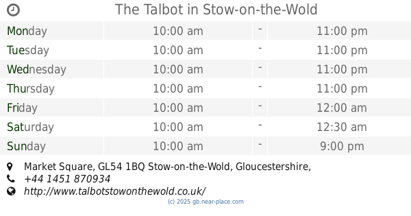
The Talbot
The Square, Market Square, Stow-on-the-Wold, Cheltenham
Bar
read more
17.083 km
The Lamb at Buckland
The Vicarage, Buckland Road, Buckland, Faringdon
Bar
read more
📑
all categories
Accounting
Administrative area level 1
Administrative area level 2
Airport
Amusement park
Aquarium
Art gallery
Atm
Bakery
Bank
Bar
Beauty salon
Bicycle store
Book store
Bowling alley
Bus station
Cafe
Campground
Car dealer
Car rental
Car repair
Car wash
Casino
Cemetery
Church
City hall
Clothing store
Colloquial area
Convenience store
Courthouse
Dentist
Department store
Doctor
Electrician
Electronics store
Embassy
Establishment
Finance
Fire station
Florist
Food
Funeral home
Furniture store
Gas station
General contractor
Grocery or supermarket
Gym
Hair care
Hardware store
Health
Hindu Temple
Home goods store
Hospital
Insurance agency
Jewelry store
Laundry
Lawyer
Library
Light rail station
Liquor store
Local government office
Locality
Locksmith
Lodging
Meal delivery
Meal takeaway
Mosque
Movie rental
Movie theater
Moving company
Museum
Natural feature
Neighborhood
Night club
Painter
Park
Parking
Pet store
Pharmacy
Physiotherapist
Place of worship
Plumber
Point of interest
Police
Political
Post office
Premise
Real estate agency
Restaurant
Roofing contractor
Route
Rv park, camping
School
Shoe store
Shopping mall
Spa
Stadium
Storage
Store
Subpremise
Subway station
Supermarket
Synagogue
Taxi stand
Train station
Transit station
Travel agency
University
Veterinary care
Zoo
administrative area level 3
administrative area level 4
sublocality level 1
↑