Bar nearby The Millers Well
United Kingdom
Bar nearby The Millers Well
The Millers Well
419-421 Barking Road, London Vereinigtes Königreich
contacts phone
:
+44
Latitude:
51.533453
, Longitude:
0.0563718
read more
nearest Bar
61 m
Feng Restaurant
443-445 Barking Road, London
Bar
read more
256 m
Hair salon
355A Barking Road, London
Bar
read more
380 m
Red Lion E6
80 High Street South, London
Bar
read more
712 m
Duke Of Connaught
United Kingdom
Bar
read more
753 m
The Overdraft Tavern
Overdraft Tavern, 200-202 High Street North, London
Bar
read more
1.309 km
The Boleyn Tavern
1 Barking Road, London
Bar
read more
1.309 km
boleyn pub
Barking Road, London
Bar
read more
1.312 km
Tribal Hostel London
1 Barking Road, London
Bar
read more
1.359 km
Ruskin
386 High Street North, London
Bar
read more
1.363 km
The Boathouse Cafe and Bar
80 Abbey Road, Barking
Bar
read more
1.369 km
The Ruskin Arms Pub & Hotel
386 High Street North, London
Bar
read more
1.481 km
The Queens
410 Green Street, London
Bar
read more
1.794 km
Black & White Lounge
2a Jenkins Lane, Barking
Bar
read more
1.924 km
No1music Bar
499 Katherine Road, London
Bar
read more
1.982 km
Vernon Arms
United Kingdom
Bar
read more
1.997 km
The Rising Sun
528 Romford Road, London
Bar
read more
2.017 km
Loyal Restaurant
United Kingdom
Bar
read more
2.018 km
William The Conqueror
United Kingdom
Bar
read more
2.095 km
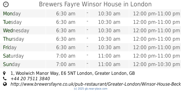
Brewers Fayre Winsor House
1 Woolwich Manor Way, London
Bar
read more
2.107 km
The Victoria Cross
Jack Cornwell Street, London
Bar
read more
2.119 km
Century Club
454 Romford Road, London
Bar
read more
2.513 km
Hudson Bay
1-5 Upton Lane, London
Bar
read more
3.299 km
The Custom House Pub
272 Victoria Dock Road, London
Bar
read more
3.494 km
ZeroSette Restaurant
2 Western Gateway, London
Bar
read more
3.506 km
Bollywood Brasserie
2 Western Gateway, London
Bar
read more
📑
all categories
Accounting
Administrative area level 1
Administrative area level 2
Airport
Amusement park
Aquarium
Art gallery
Atm
Bakery
Bank
Bar
Beauty salon
Bicycle store
Book store
Bowling alley
Bus station
Cafe
Campground
Car dealer
Car rental
Car repair
Car wash
Casino
Cemetery
Church
City hall
Clothing store
Colloquial area
Convenience store
Courthouse
Dentist
Department store
Doctor
Electrician
Electronics store
Embassy
Establishment
Finance
Fire station
Florist
Food
Funeral home
Furniture store
Gas station
General contractor
Grocery or supermarket
Gym
Hair care
Hardware store
Health
Hindu Temple
Home goods store
Hospital
Insurance agency
Jewelry store
Laundry
Lawyer
Library
Light rail station
Liquor store
Local government office
Locality
Locksmith
Lodging
Meal delivery
Meal takeaway
Mosque
Movie rental
Movie theater
Moving company
Museum
Natural feature
Neighborhood
Night club
Painter
Park
Parking
Pet store
Pharmacy
Physiotherapist
Place of worship
Plumber
Point of interest
Police
Political
Post office
Premise
Real estate agency
Restaurant
Roofing contractor
Route
Rv park, camping
School
Shoe store
Shopping mall
Spa
Stadium
Storage
Store
Subpremise
Subway station
Supermarket
Synagogue
Taxi stand
Train station
Transit station
Travel agency
University
Veterinary care
Zoo
administrative area level 3
administrative area level 4
sublocality level 1
↑