Bar nearby The Pelican Inn
United Kingdom
Bar nearby The Pelican Inn
The Pelican Inn
Bath Road, Froxfield Reino Unido
contacts phone
:
+44
Latitude:
51.4099801
, Longitude:
-1.5647524
read more
nearest Bar
2.579 km
Fantasia Events
Bel Air, Marsh Lane, Berkshire, Hungerford
Bar
read more
3.371 km
The Borough Arms
77 High Street, Hungerford
Bar
read more
3.417 km
Rafters Cafe
26-27 High Street, Hungerford
Bar
read more
3.455 km
The Hungerford Arms
113 High Street, Hungerford
Bar
read more
3.458 km
The Hungerford Arms Pub
113 High Street, Hungerford
Bar
read more
4.276 km
Three Tuns Freehouse
1 High Street, Great Bedwyn, Marlborough
Bar
read more
4.61 km
The Crown & Anchor
1 Crowood Lane, Ramsbury, Marlborough
Bar
read more
4.809 km
Goldbars
4 Orchard Close, Ramsbury, Marlborough
Bar
read more
4.809 km
Goldbars Fridge Trailer Hire
4 Orchard Close, Ramsbury, Marlborough
Bar
read more
5.207 km
The Plough
Kingston Road, Marlborough
Bar
read more
9.253 km
The Three Horseshoes
1 Stibb Green, Burbage, Marlborough
Bar
read more
9.822 km
The White Hart
123 High Street, Burbage, Marlborough
Bar
read more
10.32 km
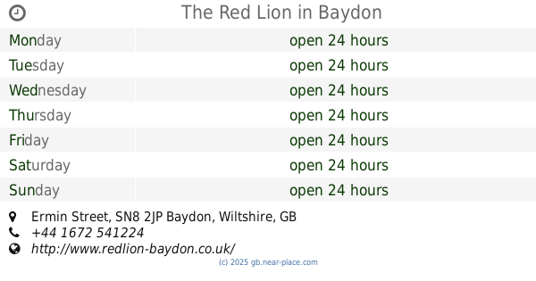
The Red Lion
Ermin Street, Baydon, Marlborough
Bar
read more
12.488 km
The Bell at Boxford
Lambourn Rd, Speen, Newbury
Bar
read more
12.488 km
Sival Hotels Ltd
Boxford, Newbury
Bar
read more
14.548 km
The Ibex Inn
39 Main Street, Chaddleworth, Newbury
Bar
read more
16.592 km
The Chequers Hotel
6-8 Oxford Street, Newbury
Bar
read more
16.69 km
Côte Brasserie - Newbury
102-103 Northbrook Street, Newbury
Bar
read more
20.328 km
The Coach
World's End, Beedon, Newbury
Bar
read more
21.295 km
The White Hart
2 High Street, Thatcham
Bar
read more
22.267 km
The Swan
Station Road, Thatcham, Newbury
Bar
read more
23.819 km
Cottage Inn
26 Broad Lane, Upper Bucklebury, Reading
Bar
read more
27.039 km
Hanney Spice
School Road, West Hanney, Wantage
Bar
read more
28.861 km
The North Star Inn
2 Stocks Lane, Steventon, Abingdon
Bar
read more
29.209 km
Mira Spice
6 High Street, Steventon, Abingdon
Bar
read more
📑
all categories
Accounting
Administrative area level 1
Administrative area level 2
Airport
Amusement park
Aquarium
Art gallery
Atm
Bakery
Bank
Bar
Beauty salon
Bicycle store
Book store
Bowling alley
Bus station
Cafe
Campground
Car dealer
Car rental
Car repair
Car wash
Casino
Cemetery
Church
City hall
Clothing store
Colloquial area
Convenience store
Courthouse
Dentist
Department store
Doctor
Electrician
Electronics store
Embassy
Establishment
Finance
Fire station
Florist
Food
Funeral home
Furniture store
Gas station
General contractor
Grocery or supermarket
Gym
Hair care
Hardware store
Health
Hindu Temple
Home goods store
Hospital
Insurance agency
Jewelry store
Laundry
Lawyer
Library
Light rail station
Liquor store
Local government office
Locality
Locksmith
Lodging
Meal delivery
Meal takeaway
Mosque
Movie rental
Movie theater
Moving company
Museum
Natural feature
Neighborhood
Night club
Painter
Park
Parking
Pet store
Pharmacy
Physiotherapist
Place of worship
Plumber
Point of interest
Police
Political
Post office
Premise
Real estate agency
Restaurant
Roofing contractor
Route
Rv park, camping
School
Shoe store
Shopping mall
Spa
Stadium
Storage
Store
Subpremise
Subway station
Supermarket
Synagogue
Taxi stand
Train station
Transit station
Travel agency
University
Veterinary care
Zoo
administrative area level 3
administrative area level 4
sublocality level 1
↑