Bar nearby The Railway Tavern
United Kingdom
Bar nearby The Railway Tavern
The Railway Tavern
Irlam Road, Urmston, Manchester Zjednoczone Królestwo
contacts phone
:
+44
Latitude:
53.4482494
, Longitude:
-2.3939553
read more
nearest Bar
628 m
Flixton Cricket and Sports Club
Lawrence Road, Manchester
Bar
read more
968 m
The Village Inn
The Village, Urmston, Manchester
Bar
read more
984 m
Fox & Hounds
Fox & Hounds, 201 Woodsend Road, Urmston, Manchester
Bar
read more
1.031 km
Church Inn
The Village, Urmston, Manchester
Bar
read more
1.224 km
The Boat House Inn.
Ferry Road, Irlam, Manchester
Bar
read more
1.332 km
The Garricks Head
Moorside Road, Manchester
Bar
read more
1.365 km
Bird I'th Hand
The Bird I'th Hand, Flixton Rd, Urmston, Manchester
Bar
read more
1.417 km
Nikkis Kitchen
262 Flixton Road, Urmston, Manchester
Bar
read more
1.632 km
Flixton Conservative Club
193 Flixton Road, Urmston, Manchester
Bar
read more
1.845 km
Tiger Moth
Swallow Drive, Irlam, Manchester
Bar
read more
1.867 km
Windmill Inn
Carrington, Manchester
Bar
read more
1.885 km
Bent Brook
161 Broadway, Urmston, Manchester
Bar
read more
1.888 km
The Roebuck
Church Road, Urmston, Manchester
Bar
read more
2.434 km
The Tim Bobbin - JD Wetherspoon
41 Flixton Road, Urmston, Manchester
Bar
read more
2.54 km
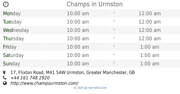
Champs
17 Flixton Road, Manchester
Bar
read more
2.738 km
Station Bar & Grill
25-29 Station Road, Urmston, Manchester
Bar
read more
2.739 km
The Assembly
31 Station Road, Urmston, Manchester
Bar
read more
3.145 km
Castle In The Air
Chill Factore, Trafford Way, Manchester
Bar
read more
3.165 km
The Mersey Farm
Carrington Ln, Ashton On Mersey, Sale
Bar
read more
3.168 km
Brewers Fayre Mersey Farm
Carrington Lane, Sale
Bar
read more
3.246 km
Brewers Fayre Coach House
Trafford Centre, Wilderspool Wood
Bar
read more
3.476 km
Las Iguanas
The Trafford Centre, The Great Hall, Manchester
Bar
read more
3.485 km
All Bar One Trafford Centre
114 The Orient THE TRAFFORD CENTRE Stretford MANCHESTER M17 8EH GB, Manchester
Bar
read more
3.527 km
Mardi Gras - JD Wetherspoon
The Trafford Centre, Trafford Boulevard, Manchester
Bar
read more
3.742 km
Swinging Bridge Table Table
Trafford Boulevard, Urmston
Bar
read more
📑
all categories
Accounting
Administrative area level 1
Administrative area level 2
Airport
Amusement park
Aquarium
Art gallery
Atm
Bakery
Bank
Bar
Beauty salon
Bicycle store
Book store
Bowling alley
Bus station
Cafe
Campground
Car dealer
Car rental
Car repair
Car wash
Casino
Cemetery
Church
City hall
Clothing store
Colloquial area
Convenience store
Courthouse
Dentist
Department store
Doctor
Electrician
Electronics store
Embassy
Establishment
Finance
Fire station
Florist
Food
Funeral home
Furniture store
Gas station
General contractor
Grocery or supermarket
Gym
Hair care
Hardware store
Health
Hindu Temple
Home goods store
Hospital
Insurance agency
Jewelry store
Laundry
Lawyer
Library
Light rail station
Liquor store
Local government office
Locality
Locksmith
Lodging
Meal delivery
Meal takeaway
Mosque
Movie rental
Movie theater
Moving company
Museum
Natural feature
Neighborhood
Night club
Painter
Park
Parking
Pet store
Pharmacy
Physiotherapist
Place of worship
Plumber
Point of interest
Police
Political
Post office
Premise
Real estate agency
Restaurant
Roofing contractor
Route
Rv park, camping
School
Shoe store
Shopping mall
Spa
Stadium
Storage
Store
Subpremise
Subway station
Supermarket
Synagogue
Taxi stand
Train station
Transit station
Travel agency
University
Veterinary care
Zoo
administrative area level 3
administrative area level 4
sublocality level 1
↑