Bar nearby Waggon & Horses
Coronavirus disease (COVID-19) Situation
confirmed cases
24910387
deaths
232112
United Kingdom
Bar nearby Waggon & Horses
Waggon & Horses
Faringdon Road, Abingdon Zjednoczone Królestwo
contacts phone
:
+44
Latitude:
51.6801886
, Longitude:
-1.4282056
read more
nearest Bar
1.448 km
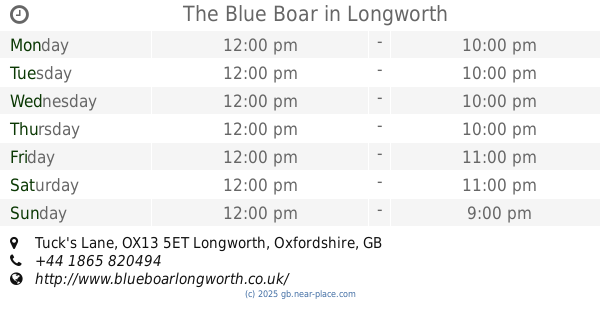
The Blue Boar
Tuck's Lane, Abingdon
Bar
read more
3.353 km
The Maybush
Abingdon Road, Newbridge, Witney
Bar
read more
3.388 km
Rose Revived
New Bridge, Witney
Bar
read more
3.756 km
The Chequers Inn
23 Main Street, Wantage
Bar
read more
4.69 km
Bon Cuisine
The Old Stone Barns, High Street, Standlake, Witney
Bar
read more
4.752 km
The Black Horse
81 High Street, Standlake, Witney
Bar
read more
5.335 km
Red Lion
Northmoor, Witney
Bar
read more
5.685 km
The Plough Inn
Eaton Road, Appleton, Abingdon
Bar
read more
7.623 km
Horse & Jockey
25 Faringdon Road, Stanford In The Vale, Faringdon, Oxfordshire
Bar
read more
8.932 km
The Vine Inn
11 Abingdon Road, Cumnor, Oxford
Bar
read more
11.02 km
Ruby Jacks
Market Place, 26, Faringdon
Bar
read more
13.426 km
Kite Inn
68-69 Mill Street, Oxford
Bar
read more
14.019 km
Cow and Creek
12 New Road, Oxford
Bar
read more
14.256 km
The Jericho Tavern
56 Walton Street, Oxford
Bar
read more
14.285 km
The Bear Inn
6 Alfred St, Oxford
Bar
read more
14.492 km
Wine Unearthed - Oxford Wine Tasting
92-94 High Street, Oxford
Bar
read more
14.58 km
Hawkwell House Hotel by Compass Hospitality
Church Way, Iffley village, Oxford
Bar
read more
14.901 km
Oxford Blue - Pizza Pots & Pints
32A Marston Street, Oxford
Bar
read more
15.104 km
Hand & Shears
Church Hanborough
Bar
read more
15.174 km
The Star
21 Rectory Road, Oxford
Bar
read more
15.33 km
The Baron
234 Cowley Road, Oxford
Bar
read more
15.633 km
Joe's Bar & Grill
260 Banbury Road, Oxford
Bar
read more
16.117 km
The Cricketers Arms
102 Temple Road, Oxford
Bar
read more
16.608 km
The Shilton Rose & Crown
Bridge Street, Shilton, Burford
Bar
read more
20.126 km
Restaurant at The Highway Inn
117 High Street, Burford
Bar
read more
📑
all categories
Accounting
Administrative area level 1
Administrative area level 2
Airport
Amusement park
Aquarium
Art gallery
Atm
Bakery
Bank
Bar
Beauty salon
Bicycle store
Book store
Bowling alley
Bus station
Cafe
Campground
Car dealer
Car rental
Car repair
Car wash
Casino
Cemetery
Church
City hall
Clothing store
Colloquial area
Convenience store
Courthouse
Dentist
Department store
Doctor
Electrician
Electronics store
Embassy
Establishment
Finance
Fire station
Florist
Food
Funeral home
Furniture store
Gas station
General contractor
Grocery or supermarket
Gym
Hair care
Hardware store
Health
Hindu Temple
Home goods store
Hospital
Insurance agency
Jewelry store
Laundry
Lawyer
Library
Light rail station
Liquor store
Local government office
Locality
Locksmith
Lodging
Meal delivery
Meal takeaway
Mosque
Movie rental
Movie theater
Moving company
Museum
Natural feature
Neighborhood
Night club
Painter
Park
Parking
Pet store
Pharmacy
Physiotherapist
Place of worship
Plumber
Point of interest
Police
Political
Post office
Premise
Real estate agency
Restaurant
Roofing contractor
Route
Rv park, camping
School
Shoe store
Shopping mall
Spa
Stadium
Storage
Store
Subpremise
Subway station
Supermarket
Synagogue
Taxi stand
Train station
Transit station
Travel agency
University
Veterinary care
Zoo
administrative area level 3
administrative area level 4
sublocality level 1
↑