Cafe nearby Area Cafe
United Kingdom
Cafe nearby Area Cafe
Area Cafe
82 Castle Street, Cambridge United Kingdom
contacts phone
:
+44
Latitude:
52.2132757
, Longitude:
0.1122843
read more
nearest Cafe
512 m
Fitzbillies
36 Bridge Street, Cambridge
Cafe
read more
617 m
Bridges Cambridge
20 Bridge Street, Cambridge
Cafe
read more
669 m
Coffee Tree Cambridge
184A Histon Road, Cambridge
Cafe
read more
674 m
Bould Brothers Coffee
16 Round Church Street, Cambridge
Cafe
read more
704 m
Le Patissier
11 Saint Johns Street, Cambridge
Cafe
read more
705 m
Crêpeaffaire
66 Bridge Street, Cambridge
Cafe
read more
741 m
Costa For Coffee Lovers
Friends Meeting House, 12 Jesus Lane, Cambridge
Cafe
read more
865 m
Harriets Cafe Tearooms
16-17 Green Street, Cambridge
Cafe
read more
895 m
No 30
32 Chesterton Road, Cambridge
Cafe
read more
895 m
No 30
30 Chesterton Road, Cambridge
Cafe
read more
913 m
Baroosh
8 Market Passage, Cambridge
Cafe
read more
924 m
Cafe Bread & Butter
6 Milton Road, Cambridge
Cafe
read more
939 m
Cafe at Abantu
42 Hobson Street, Cambridge
Cafe
read more
967 m
Stem + Glory King st
13 King Street, Cambridge
Cafe
read more
982 m
Bubble Ground Cambridge
Cambridge
Cafe
read more
1.013 km
Caffè Nero
17 King's Parade, City Centre, Cambridge
Cafe
read more
1.018 km
CAFFE MOBILE
5 Market Hill, Cambridge
Cafe
read more
1.043 km
The Urban Shed
62-64 King Street, Cambridge
Cafe
read more
1.053 km
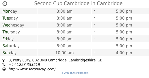
Second Cup Cambridge
3 Petty Cury, Cambridge
Cafe
read more
1.062 km
Hotel Chocolat
43 Lion Yard, Cambridge
Cafe
read more
1.062 km
Whittard of Chelsea
24 Petty Cury, Cambridge
Cafe
read more
1.062 km
Hotel Chocolat
43 Petty Cury, Cambridge
Cafe
read more
1.073 km
Soboro Bakery
17 Petty Cury, Cambridge
Cafe
read more
1.078 km
Aromi
3 Peas Hill, Cambridge
Cafe
read more
1.245 km
Savino's
3 Emmanuel Street, Cambridge
Cafe
read more
📑
all categories
Accounting
Administrative area level 1
Administrative area level 2
Airport
Amusement park
Aquarium
Art gallery
Atm
Bakery
Bank
Bar
Beauty salon
Bicycle store
Book store
Bowling alley
Bus station
Cafe
Campground
Car dealer
Car rental
Car repair
Car wash
Casino
Cemetery
Church
City hall
Clothing store
Colloquial area
Convenience store
Courthouse
Dentist
Department store
Doctor
Electrician
Electronics store
Embassy
Establishment
Finance
Fire station
Florist
Food
Funeral home
Furniture store
Gas station
General contractor
Grocery or supermarket
Gym
Hair care
Hardware store
Health
Hindu Temple
Home goods store
Hospital
Insurance agency
Jewelry store
Laundry
Lawyer
Library
Light rail station
Liquor store
Local government office
Locality
Locksmith
Lodging
Meal delivery
Meal takeaway
Mosque
Movie rental
Movie theater
Moving company
Museum
Natural feature
Neighborhood
Night club
Painter
Park
Parking
Pet store
Pharmacy
Physiotherapist
Place of worship
Plumber
Point of interest
Police
Political
Post office
Premise
Real estate agency
Restaurant
Roofing contractor
Route
Rv park, camping
School
Shoe store
Shopping mall
Spa
Stadium
Storage
Store
Subpremise
Subway station
Supermarket
Synagogue
Taxi stand
Train station
Transit station
Travel agency
University
Veterinary care
Zoo
administrative area level 3
administrative area level 4
sublocality level 1
↑