Cafe nearby Dandelion Cafe
Coronavirus disease (COVID-19) Situation
confirmed cases
24910387
deaths
232112
United Kingdom
Cafe nearby Dandelion Cafe
Dandelion Cafe
14 George IV Street, Cambridge Reino Unido
contacts phone
:
+44
Latitude:
52.1977778
, Longitude:
0.1279165
read more
nearest Cafe
301 m
Regent Cafe
77A Regent Street, City Centre, Cambridge
Cafe
read more
331 m
Hi sweety bakery
71A Regent Street, Cambridge
Cafe
read more
338 m
Joy
4 Claremont, Cambridge
Cafe
read more
357 m
Ooshi!
61 Regent Street, Cambridge
Cafe
read more
521 m
NOVI
12 Regent Street, Cambridge
Cafe
read more
576 m
Morrisons Cafe
Lincoln Road, Peterborough
Cafe
read more
596 m
Rotana Cafe
50 Mill Road, Cambridge
Cafe
read more
649 m
The Garden Kitchen
82 Mill Rd, Cambridge
Cafe
read more
702 m
Costa Coffee
A1307, Cambridge
Cafe
read more
746 m
nespresso bar John Lewis Cambridge
3-6 Downing Street, Cambridge
Cafe
read more
771 m
Zio Mario, Artisan Bakery & Coffee
21, Station Place, In front of Bus Stop n.1, Cambridge
Cafe
read more
782 m
Trockel, Ulmann & Freunde
13 Pembroke Street, Cambridge
Cafe
read more
806 m
Costa Coffee
Unit K5 Grand Arcade, Saint Andrew's Street, Cambridge
Cafe
read more
811 m
Costa Coffee
21 Saint Andrew's Street, Cambridge
Cafe
read more
831 m
Espresso Lane
1 Botolph Lane, Cambridge
Cafe
read more
955 m
Soboro Bakery
17 Petty Cury, Cambridge
Cafe
read more
966 m
Hotel Chocolat
43 Lion Yard, Cambridge
Cafe
read more
974 m
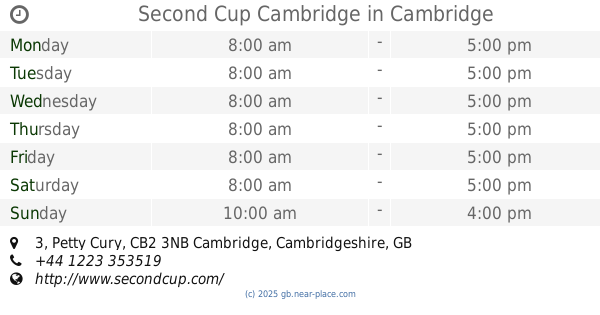
Second Cup Cambridge
3 Petty Cury, Cambridge
Cafe
read more
996 m
Caffè Nero
22 Fitzroy Street, Cambridge
Cafe
read more
999 m
Arena
8 Burleigh Street, Cambridge
Cafe
read more
1.042 km
Caffè Nero
17 King's Parade, City Centre, Cambridge
Cafe
read more
1.048 km
Bubble Ground Cambridge
Cambridge
Cafe
read more
1.114 km
Baroosh
8 Market Passage, Cambridge
Cafe
read more
1.146 km
Costa Coffee
Unit 3 The Marque, 6 Cherry Hinton Road, Cambridge
Cafe
read more
1.16 km
Harriets Cafe Tearooms
16-17 Green Street, Cambridge
Cafe
read more
📑
all categories
Accounting
Administrative area level 1
Administrative area level 2
Airport
Amusement park
Aquarium
Art gallery
Atm
Bakery
Bank
Bar
Beauty salon
Bicycle store
Book store
Bowling alley
Bus station
Cafe
Campground
Car dealer
Car rental
Car repair
Car wash
Casino
Cemetery
Church
City hall
Clothing store
Colloquial area
Convenience store
Courthouse
Dentist
Department store
Doctor
Electrician
Electronics store
Embassy
Establishment
Finance
Fire station
Florist
Food
Funeral home
Furniture store
Gas station
General contractor
Grocery or supermarket
Gym
Hair care
Hardware store
Health
Hindu Temple
Home goods store
Hospital
Insurance agency
Jewelry store
Laundry
Lawyer
Library
Light rail station
Liquor store
Local government office
Locality
Locksmith
Lodging
Meal delivery
Meal takeaway
Mosque
Movie rental
Movie theater
Moving company
Museum
Natural feature
Neighborhood
Night club
Painter
Park
Parking
Pet store
Pharmacy
Physiotherapist
Place of worship
Plumber
Point of interest
Police
Political
Post office
Premise
Real estate agency
Restaurant
Roofing contractor
Route
Rv park, camping
School
Shoe store
Shopping mall
Spa
Stadium
Storage
Store
Subpremise
Subway station
Supermarket
Synagogue
Taxi stand
Train station
Transit station
Travel agency
University
Veterinary care
Zoo
administrative area level 3
administrative area level 4
sublocality level 1
↑