Cafe nearby The High Street Cafe
United Kingdom
Cafe nearby The High Street Cafe
The High Street Cafe
67 High Street, Oxford United Kingdom
contacts phone
:
+44
Latitude:
51.7521913
, Longitude:
-1.248787
read more
nearest Cafe
123 m
Queen's Lane Coffee House
40 High Street, Oxford
Cafe
read more
433 m
Cous Cous Cafe
19-20 Saint Clement's Street, Oxford
Cafe
read more
495 m
Cafe Coco
23 Cowley Road, Oxford
Cafe
read more
524 m
Whittard of Chelsea
15 High Street, Oxford
Cafe
read more
527 m
Bodleian Library Café
Weston Library, Broad Street, Oxford
Cafe
read more
566 m
terrace oxford
Covered Market, Oxford
Cafe
read more
572 m
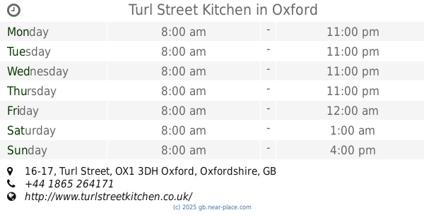
Turl Street Kitchen
16-17 Turl Street, Oxford
Cafe
read more
591 m
Coba bubble tea
Golden Cross Walk, 9 Cornmarket Street, Oxford
Cafe
read more
597 m
George & Danver
94 Saint Aldate's, Oxford
Cafe
read more
635 m
Fernando's Cafe
Queens Street, Carfax Garden, Oxford
Cafe
read more
687 m
Costa
55 Cornmarket Street, Oxford
Cafe
read more
696 m
1738 Tea Room
Boswells, 1, 4 Broad Street, Oxford
Cafe
read more
711 m
Millefeuille
86 Cowley Road, Oxford
Cafe
read more
724 m
BRICK @ Modern Art Oxford
30 Pembroke Street, Oxford
Cafe
read more
746 m
Ratio Café
4 George Street, Oxford
Cafe
read more
780 m
Mortons
22 New Inn Hall Street, Oxford
Cafe
read more
802 m
Percy's
The Old Music Hall, Cowley Road, Oxford
Cafe
read more
807 m
Cinnamon Cafe
28 Friars Entry, Oxford
Cafe
read more
905 m
Victors
Westgate Shopping Centre, Unit RU5, The Terrace, Bonn Square, Oxford
Cafe
read more
944 m
Refresh
131 Cowley Road, Oxford
Cafe
read more
948 m
Combibos Coffee
93 Gloucester Street, Oxford
Cafe
read more
948 m
Caffè Nero
91 Gloucester Green, Oxford
Cafe
read more
991 m
The Shake Lab
Westgate Oxford, Castle Street, Oxford
Cafe
read more
1.05 km
Beetroot
166 Cowley Road, Oxford
Cafe
read more
1.159 km
Common Ground
37-38 Little Clarendon Street, Oxford
Cafe
read more
📑
all categories
Accounting
Administrative area level 1
Administrative area level 2
Airport
Amusement park
Aquarium
Art gallery
Atm
Bakery
Bank
Bar
Beauty salon
Bicycle store
Book store
Bowling alley
Bus station
Cafe
Campground
Car dealer
Car rental
Car repair
Car wash
Casino
Cemetery
Church
City hall
Clothing store
Colloquial area
Convenience store
Courthouse
Dentist
Department store
Doctor
Electrician
Electronics store
Embassy
Establishment
Finance
Fire station
Florist
Food
Funeral home
Furniture store
Gas station
General contractor
Grocery or supermarket
Gym
Hair care
Hardware store
Health
Hindu Temple
Home goods store
Hospital
Insurance agency
Jewelry store
Laundry
Lawyer
Library
Light rail station
Liquor store
Local government office
Locality
Locksmith
Lodging
Meal delivery
Meal takeaway
Mosque
Movie rental
Movie theater
Moving company
Museum
Natural feature
Neighborhood
Night club
Painter
Park
Parking
Pet store
Pharmacy
Physiotherapist
Place of worship
Plumber
Point of interest
Police
Political
Post office
Premise
Real estate agency
Restaurant
Roofing contractor
Route
Rv park, camping
School
Shoe store
Shopping mall
Spa
Stadium
Storage
Store
Subpremise
Subway station
Supermarket
Synagogue
Taxi stand
Train station
Transit station
Travel agency
University
Veterinary care
Zoo
administrative area level 3
administrative area level 4
sublocality level 1
↑