Convenience store nearby Avenue Premier
Coronavirus disease (COVID-19) Situation
confirmed cases
24910387
deaths
232112
United Kingdom
Convenience store nearby Avenue Premier
Avenue Premier
59 Thornbury Park Avenue, Plymouth Det Forenede Kongerige
contacts phone
:
+44
Latitude:
50.3914635
, Longitude:
-4.1402402
read more
nearest Convenience store
500 m
Co-op Food - Peverell
2 Peverell Park Road, Peverell, Plymouth
Convenience store
read more
520 m
McColl's
Jubilee Buildings, Peverell Park Road, Plymouth
Convenience store
read more
595 m
Trelawney Stores
55 Trelawney Road, Plymouth
Convenience store
read more
765 m
Mannamead Stores
2 Eggbuckland Road, Plymouth
Convenience store
read more
814 m
Co-op Food - Beacon Park
The Beacon, 288-296, Beacon Park Road, Plymouth
Convenience store
read more
1.173 km
Premier
45 Mutley Plain, Plymouth
Convenience store
read more
1.471 km
McColl's
122 Alexandra Road, Plymouth
Convenience store
read more
1.541 km
Spar
6-8 The Station Concourse, Plymouth Railway Station, Plymouth
Convenience store
read more
1.559 km
The Co-operative Food
147 Eggbuckland Road, Plymouth
Convenience store
read more
1.646 km
Ham Wine Stores
7 Ham Green, Plymouth
Convenience store
read more
1.677 km
SPAR
25-27 Stuart Road, Plymouth
Convenience store
read more
1.869 km
Co-op Food - Wolseley Road
Wolseley Close, Ford, Plymouth
Convenience store
read more
1.869 km
Co-op Food
Wolseley Close, Ford, Plymouth
Convenience store
read more
1.887 km
Poets Corner Stores
42 Burns Avenue, Plymouth
Convenience store
read more
1.898 km
The Co-operative Food
27 Morshead Rd, Plymouth
Convenience store
read more
1.898 km
Co-op Food - Crownhill
27 Morshead Road, Plymouth
Convenience store
read more
1.918 km
L M Stores
264 North Road West, Plymouth
Convenience store
read more
2.004 km
Mount Gould Stores
46 Mount Gould Road, Plymouth
Convenience store
read more
2.009 km
Co-op Food - Regent Street
10 Regent Street, Plymouth
Convenience store
read more
2.041 km
Co-op Food - Wilton Street
89 Wilton Street, Millbridge, Plymouth
Convenience store
read more
2.064 km
Premier Express
35-36, Regent Street, Plymouth
Convenience store
read more
2.129 km
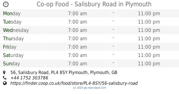
Co-op Food - Salisbury Road
56 Salisbury Road, Plymouth
Convenience store
read more
2.14 km
Co-op Food - Stoke Village
36-40 Devonport Road, Plymouth
Convenience store
read more
2.219 km
Eggbuckland Stores
67-69 Saint Edward Gardens, Plymouth
Convenience store
read more
2.307 km
Co-op Food
131 Beaumont Road, Plymouth
Convenience store
read more
📑
all categories
Accounting
Administrative area level 1
Administrative area level 2
Airport
Amusement park
Aquarium
Art gallery
Atm
Bakery
Bank
Bar
Beauty salon
Bicycle store
Book store
Bowling alley
Bus station
Cafe
Campground
Car dealer
Car rental
Car repair
Car wash
Casino
Cemetery
Church
City hall
Clothing store
Colloquial area
Convenience store
Courthouse
Dentist
Department store
Doctor
Electrician
Electronics store
Embassy
Establishment
Finance
Fire station
Florist
Food
Funeral home
Furniture store
Gas station
General contractor
Grocery or supermarket
Gym
Hair care
Hardware store
Health
Hindu Temple
Home goods store
Hospital
Insurance agency
Jewelry store
Laundry
Lawyer
Library
Light rail station
Liquor store
Local government office
Locality
Locksmith
Lodging
Meal delivery
Meal takeaway
Mosque
Movie rental
Movie theater
Moving company
Museum
Natural feature
Neighborhood
Night club
Painter
Park
Parking
Pet store
Pharmacy
Physiotherapist
Place of worship
Plumber
Point of interest
Police
Political
Post office
Premise
Real estate agency
Restaurant
Roofing contractor
Route
Rv park, camping
School
Shoe store
Shopping mall
Spa
Stadium
Storage
Store
Subpremise
Subway station
Supermarket
Synagogue
Taxi stand
Train station
Transit station
Travel agency
University
Veterinary care
Zoo
administrative area level 3
administrative area level 4
sublocality level 1
↑