Convenience store nearby Tereza's Food Store
United Kingdom
Convenience store nearby Tereza's Food Store
Tereza's Food Store
United Kingdom Reino Unido
contacts phone
:
+44
Latitude:
53.4143291
, Longitude:
-2.9162896
read more
nearest Convenience store
441 m
PRM PHOTHIHAI
394 Prescot Road, Liverpool
Convenience store
read more
537 m
Prm
Prescot Road, Liverpool
Convenience store
read more
598 m
Green Lane Mini-Mart
181 Green Lane, Liverpool
Convenience store
read more
609 m
S & H Wine & General
179 Green Lane, Liverpool
Convenience store
read more
640 m
The Corner Shop
44 Oakhill Road, Liverpool
Convenience store
read more
1.165 km
McColl's
7-8 The Parade, Northway Wavertree, Liverpool
Convenience store
read more
1.299 km
Don's Rocket News Ltd
1 Bowring Park Road, Liverpool
Convenience store
read more
1.529 km
McColl's
637-643 West Derby Road, Liverpool
Convenience store
read more
1.569 km
African food shop ( international food store
68 Prescot Road, Liverpool
Convenience store
read more
1.615 km
SPAR
Queens Drive, West Derby, Liverpool
Convenience store
read more
1.622 km
Barra Boy
541 West Derby Road, Liverpool
Convenience store
read more
1.692 km
Hs Food Store
United Kingdom
Convenience store
read more
1.728 km
F & X Minimarket
109 Picton Road, Liverpool
Convenience store
read more
1.754 km
PTU Food & Wine
PTU Food & Wine, 196 Picton Road, Liverpool
Convenience store
read more
1.771 km
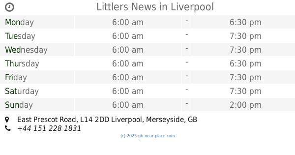
Littlers News
East Prescot Road, Liverpool
Convenience store
read more
1.842 km
Co-op Food
Church Road North, Liverpool
Convenience store
read more
1.842 km
Co-op Food - Wavertree - Church Road North
Church Road North, Liverpool
Convenience store
read more
1.867 km
Co-op Food - Darley Drive
Darley Drive, Liverpool
Convenience store
read more
1.955 km
Shaya Convenience Store
22 Lower Breck Road, Liverpool
Convenience store
read more
1.994 km
Sky Express
23 Deysbrook Lane, Liverpool
Convenience store
read more
2.037 km
The Dairy
16 Glamis Road, Liverpool
Convenience store
read more
2.049 km
One Stop Stores Ltd
1-3 Honey's Green, Liverpool
Convenience store
read more
2.242 km
Yafs News Convenience Store
United Kingdom
Convenience store
read more
2.282 km
Co-op Food - Lawrence Road
35 Lawrence Road, Liverpool
Convenience store
read more
2.313 km
Arbela
36 Lawrence Road, Liverpool
Convenience store
read more
📑
all categories
Accounting
Administrative area level 1
Administrative area level 2
Airport
Amusement park
Aquarium
Art gallery
Atm
Bakery
Bank
Bar
Beauty salon
Bicycle store
Book store
Bowling alley
Bus station
Cafe
Campground
Car dealer
Car rental
Car repair
Car wash
Casino
Cemetery
Church
City hall
Clothing store
Colloquial area
Convenience store
Courthouse
Dentist
Department store
Doctor
Electrician
Electronics store
Embassy
Establishment
Finance
Fire station
Florist
Food
Funeral home
Furniture store
Gas station
General contractor
Grocery or supermarket
Gym
Hair care
Hardware store
Health
Hindu Temple
Home goods store
Hospital
Insurance agency
Jewelry store
Laundry
Lawyer
Library
Light rail station
Liquor store
Local government office
Locality
Locksmith
Lodging
Meal delivery
Meal takeaway
Mosque
Movie rental
Movie theater
Moving company
Museum
Natural feature
Neighborhood
Night club
Painter
Park
Parking
Pet store
Pharmacy
Physiotherapist
Place of worship
Plumber
Point of interest
Police
Political
Post office
Premise
Real estate agency
Restaurant
Roofing contractor
Route
Rv park, camping
School
Shoe store
Shopping mall
Spa
Stadium
Storage
Store
Subpremise
Subway station
Supermarket
Synagogue
Taxi stand
Train station
Transit station
Travel agency
University
Veterinary care
Zoo
administrative area level 3
administrative area level 4
sublocality level 1
↑