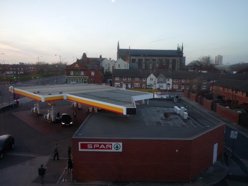
Gas station nearby BP
Coronavirus disease (COVID-19) Situation
confirmed cases
24910387
deaths
232112
United Kingdom
Gas station nearby BP
BP
121-129, Great Howard Street, L3 7AT, Liverpool, Merseyside, GB Storbritannien
contacts phone
:
+44 7342 947118
website:
www.bp.com
Latitude:
53.41729
, Longitude:
-2.9969235
larger map & directions
read more
nearest Gas station
5 m
Applegreen
121 Great Howard Street, Liverpool
Gas station
read more
476 m
Costco Petrol Station
30 Waterloo Road, Liverpool
Gas station
read more
476 m
Costco
30 Waterloo Road, Liverpool
Gas station
read more
687 m
County Oil
157 Regent Rd, Liverpool
Gas station
read more
1.112 km
SCOTLAND ROAD SERVICE STATION
332 Scotland Road, Liverpool
Gas station
read more
1.299 km
Sainsbury's Petrol Station
Great Homer Street, Liverpool
Gas station
read more
1.299 km
Sainsbury's Petrol Station
26 Jennifer Way, Liverpool
Gas station
read more
1.378 km
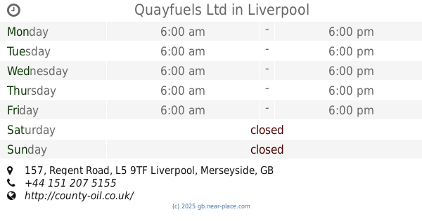
Quayfuels Ltd
157 Regent Road, Liverpool
Gas station
read more
1.866 km
BP
Islington, Liverpool
Gas station
read more
1.869 km
BP
Islington, Islington Road, Liverpool
Gas station
read more
2.14 km
Shell
Liscard Road, Wallasey
Gas station
read more
2.142 km
Motor Fuel Group
Lloyds Corner Service Station, Wallasey
Gas station
read more
2.195 km
BP
93-113 King Street, Wallasey
Gas station
read more
2.415 km
Shell
United Kingdom
Gas station
read more
2.6 km
Asda Petrol
58 Breckfield Road South, Liverpool
Gas station
read more
2.688 km
Petrol Station
12 Saint Albans, Liverpool
Gas station
read more
2.704 km
Texaco
21 Barlow Lane, Kirkdale, Liverpool
Gas station
read more
2.73 km
Asda
Saint Albans, Liverpool
Gas station
read more
2.812 km
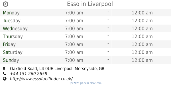
Esso
Oakfield Road, Liverpool
Gas station
read more
3.098 km
Esso
Brewster Street, Liverpool
Gas station
read more
3.169 km
Mohawk
United Kingdom
Gas station
read more
3.291 km
Gulf
Priory Road, Liverpool
Gas station
read more
3.292 km
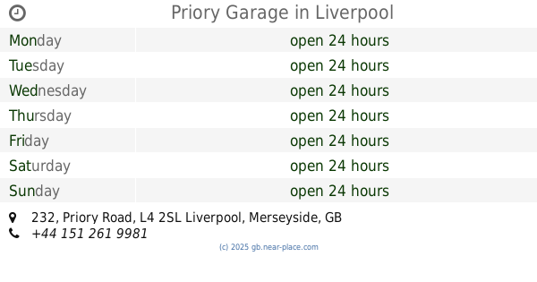
Priory Garage
232 Priory Road, Liverpool
Gas station
read more
3.38 km
Shell Select
100 Derby Road, Bootle
Gas station
read more
5.857 km
Sainsbury's Petrol Station
342A Woodchurch Road, Birkenhead
Gas station
read more
📑
all categories
Accounting
Administrative area level 1
Administrative area level 2
Airport
Amusement park
Aquarium
Art gallery
Atm
Bakery
Bank
Bar
Beauty salon
Bicycle store
Book store
Bowling alley
Bus station
Cafe
Campground
Car dealer
Car rental
Car repair
Car wash
Casino
Cemetery
Church
City hall
Clothing store
Colloquial area
Convenience store
Courthouse
Dentist
Department store
Doctor
Electrician
Electronics store
Embassy
Establishment
Finance
Fire station
Florist
Food
Funeral home
Furniture store
Gas station
General contractor
Grocery or supermarket
Gym
Hair care
Hardware store
Health
Hindu Temple
Home goods store
Hospital
Insurance agency
Jewelry store
Laundry
Lawyer
Library
Light rail station
Liquor store
Local government office
Locality
Locksmith
Lodging
Meal delivery
Meal takeaway
Mosque
Movie rental
Movie theater
Moving company
Museum
Natural feature
Neighborhood
Night club
Painter
Park
Parking
Pet store
Pharmacy
Physiotherapist
Place of worship
Plumber
Point of interest
Police
Political
Post office
Premise
Real estate agency
Restaurant
Roofing contractor
Route
Rv park, camping
School
Shoe store
Shopping mall
Spa
Stadium
Storage
Store
Subpremise
Subway station
Supermarket
Synagogue
Taxi stand
Train station
Transit station
Travel agency
University
Veterinary care
Zoo
administrative area level 3
administrative area level 4
sublocality level 1
↑