Gas station nearby Gasolinera Aeropuerto B'ham
Coronavirus disease (COVID-19) Situation
confirmed cases
24910387
deaths
232112
United Kingdom
Gas station nearby Gasolinera Aeropuerto B'ham
Gasolinera Aeropuerto B'ham
Bickenhill, Solihull United Kingdom
contacts phone
:
+44
Latitude:
52.4447729
, Longitude:
-1.7216805
read more
nearest Gas station
16 m
Esso
COVENTRY ROAD, Solihull
Gas station
read more
3.215 km
Marston Green Filling Station
53 Station Road, Marston Green, Birmingham
Gas station
read more
3.221 km
BP
59B Station Road, Marston Green, Birmingham
Gas station
read more
4.955 km
Esso
Cooks Lane, West Midlands
Gas station
read more
5.194 km
BP
Chester Road, Birmingham
Gas station
read more
5.595 km
Leaway Service Station
Meadway, Birmingham
Gas station
read more
6.232 km
Texaco
1644 Coventry Road, Birmingham
Gas station
read more
6.512 km
Jet Petrol Station
Flaxley Road, Birmingham
Gas station
read more
6.732 km
Timberley Service Station
306 Chester Road, Solihull, Birmingham
Gas station
read more
9.709 km
Lime Petrol Station
Small Heath Highway, Birmingham
Gas station
read more
9.9 km
Z H Garages
242 Alum Rock Road, Birmingham
Gas station
read more
11.734 km
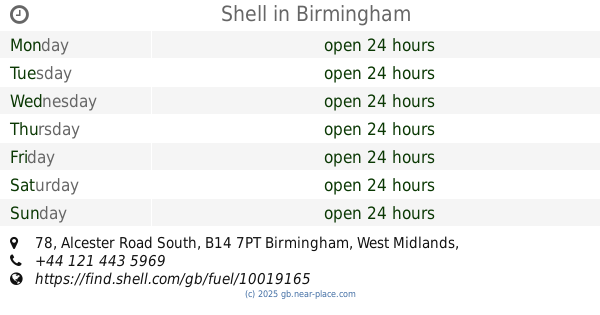
Shell
78 Alcester Road South, Birmingham
Gas station
read more
13.273 km
Shell
Bath Row, Birmingham
Gas station
read more
13.345 km
A1 Garages Texaco
110 Constitution Hill, Birmingham
Gas station
read more
13.435 km
Morrisons Petrol Station
Alvis Retail Park, Holyhead Road, Coventry
Gas station
read more
13.523 km
The Gas Station
12 Pershore Road, Birmingham
Gas station
read more
13.578 km
Jet Petrol Station
Reddicap Heath Road, Sutton Coldfield
Gas station
read more
13.968 km
BP
Jubilee Crescent, Coventry
Gas station
read more
14.051 km
Esso
93-99 Nursery Road, Birmingham
Gas station
read more
14.058 km
Qayoum Hockley Service Station
Hockley Nursery Road, Birmingham Area, Birmingham
Gas station
read more
14.135 km
Tesco Petrol Station
7BH, Camden Street, Birmingham
Gas station
read more
14.153 km
Esso
479 Bristol Road, Birmingham
Gas station
read more
14.682 km
ricardo celvic oil and gas limited
39 Smithford Way, Coventry
Gas station
read more
15.085 km
Esso
Whitehouse Common Road, Sutton Coldfield
Gas station
read more
15.145 km
TEXACO
Icknield Port Road, Birmingham
Gas station
read more
📑
all categories
Accounting
Administrative area level 1
Administrative area level 2
Airport
Amusement park
Aquarium
Art gallery
Atm
Bakery
Bank
Bar
Beauty salon
Bicycle store
Book store
Bowling alley
Bus station
Cafe
Campground
Car dealer
Car rental
Car repair
Car wash
Casino
Cemetery
Church
City hall
Clothing store
Colloquial area
Convenience store
Courthouse
Dentist
Department store
Doctor
Electrician
Electronics store
Embassy
Establishment
Finance
Fire station
Florist
Food
Funeral home
Furniture store
Gas station
General contractor
Grocery or supermarket
Gym
Hair care
Hardware store
Health
Hindu Temple
Home goods store
Hospital
Insurance agency
Jewelry store
Laundry
Lawyer
Library
Light rail station
Liquor store
Local government office
Locality
Locksmith
Lodging
Meal delivery
Meal takeaway
Mosque
Movie rental
Movie theater
Moving company
Museum
Natural feature
Neighborhood
Night club
Painter
Park
Parking
Pet store
Pharmacy
Physiotherapist
Place of worship
Plumber
Point of interest
Police
Political
Post office
Premise
Real estate agency
Restaurant
Roofing contractor
Route
Rv park, camping
School
Shoe store
Shopping mall
Spa
Stadium
Storage
Store
Subpremise
Subway station
Supermarket
Synagogue
Taxi stand
Train station
Transit station
Travel agency
University
Veterinary care
Zoo
administrative area level 3
administrative area level 4
sublocality level 1
↑