Gas station nearby Morrisons Petrol Station
United Kingdom
Gas station nearby Morrisons Petrol Station
Morrisons Petrol Station
214-216 New Road, Rubery, Rednal, Birmingham Det Forenede Kongerige
contacts phone
:
+44
Latitude:
52.3966269
, Longitude:
-2.0070075
read more
nearest Gas station
14 m
Morrisons Petrol Station
Rubery, Birmingham
Gas station
read more
509 m
Jet Petrol Station
Cock Hill Lane, Rednal
Gas station
read more
2.495 km
Shell
1020 Bristol Road South, Birmingham
Gas station
read more
2.511 km
Shell Select
1020 Bristol Road South, Birmingham
Gas station
read more
2.697 km
BP
Longbridge Lane, Birmingham
Gas station
read more
2.834 km
Sainsbury's Petrol Station
45 Frankley Beeches Road, Birmingham
Gas station
read more
3.145 km
Sainsbury's Petrol Station
Frankley Beeches Road, Birmingham
Gas station
read more
3.197 km
ESSO-KSG- OPEN 24 HOURS
Church Hill, Birmingham
Gas station
read more
3.209 km
Esso
Station Road, Church Hill, Birmingham
Gas station
read more
3.568 km
BP
M5 Junction 3/4, Birmingham
Gas station
read more
3.573 km
BP Frankley Services.
M5, Quinton South, Birmingham
Gas station
read more
3.617 km
Frankley Services, Southbound
Frankley, Birmingham
Gas station
read more
3.761 km
BP
3-4 Junction, Birmingham
Gas station
read more
3.862 km
Moto Frankley
Frankley Service Area M5 Mot Illey Lane, Birmingham
Gas station
read more
5.232 km
Esso
Barnes Hill, Birmingham
Gas station
read more
5.348 km
BP
Alwold Road, Birmingham
Gas station
read more
6.98 km
Shell
295 Harborne Lane, Birmingham
Gas station
read more
7.057 km
The Gas Station
12 Pershore Road, Birmingham
Gas station
read more
8.579 km
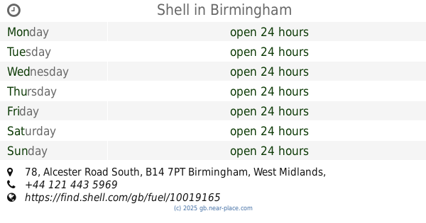
Shell
78 Alcester Road South, Birmingham
Gas station
read more
10.836 km
TEXACO
Icknield Port Road, Birmingham
Gas station
read more
11.842 km
Sainsbury's Petrol Station
Freeth Street, Oldbury
Gas station
read more
12.457 km
Lime Petrol Station
Small Heath Highway, Birmingham
Gas station
read more
13.178 km
Qayoum Hockley Service Station
Hockley Nursery Road, Birmingham Area, Birmingham
Gas station
read more
13.196 km
Esso
93-99 Nursery Road, Birmingham
Gas station
read more
14.838 km
Z H Garages
242 Alum Rock Road, Birmingham
Gas station
read more
📑
all categories
Accounting
Administrative area level 1
Administrative area level 2
Airport
Amusement park
Aquarium
Art gallery
Atm
Bakery
Bank
Bar
Beauty salon
Bicycle store
Book store
Bowling alley
Bus station
Cafe
Campground
Car dealer
Car rental
Car repair
Car wash
Casino
Cemetery
Church
City hall
Clothing store
Colloquial area
Convenience store
Courthouse
Dentist
Department store
Doctor
Electrician
Electronics store
Embassy
Establishment
Finance
Fire station
Florist
Food
Funeral home
Furniture store
Gas station
General contractor
Grocery or supermarket
Gym
Hair care
Hardware store
Health
Hindu Temple
Home goods store
Hospital
Insurance agency
Jewelry store
Laundry
Lawyer
Library
Light rail station
Liquor store
Local government office
Locality
Locksmith
Lodging
Meal delivery
Meal takeaway
Mosque
Movie rental
Movie theater
Moving company
Museum
Natural feature
Neighborhood
Night club
Painter
Park
Parking
Pet store
Pharmacy
Physiotherapist
Place of worship
Plumber
Point of interest
Police
Political
Post office
Premise
Real estate agency
Restaurant
Roofing contractor
Route
Rv park, camping
School
Shoe store
Shopping mall
Spa
Stadium
Storage
Store
Subpremise
Subway station
Supermarket
Synagogue
Taxi stand
Train station
Transit station
Travel agency
University
Veterinary care
Zoo
administrative area level 3
administrative area level 4
sublocality level 1
↑