Gas station nearby Tesco
Coronavirus disease (COVID-19) Situation
confirmed cases
24910387
deaths
232112
United Kingdom
Gas station nearby Tesco
Tesco
Bursledon, Southampton SO31 8GE, Reino Unido
contacts phone
:
+44
website:
www.tesco.com
Latitude:
50.8934037
, Longitude:
-1.3207236
larger map & directions
read more
nearest Gas station
1.183 km
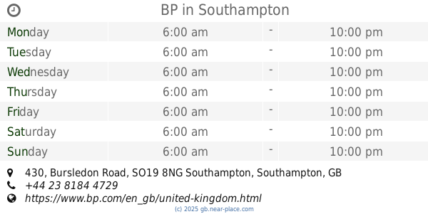
BP
430 Bursledon Road, Southampton
Gas station
read more
2.6 km
Co op food
15A Thornhill Park Road, Southampton
Gas station
read more
2.615 km
Texaco
Thornhill Park Road, Southampton
Gas station
read more
2.776 km
Sainsbury's Petrol Station
Tollbar Way, Hedge End, Southampton
Gas station
read more
2.999 km
BP
170 Portsmouth Road, Southampton
Gas station
read more
3.341 km
Texaco Service Station
Botley, Southampton
Gas station
read more
3.907 km
Esso
149 West End Road, Southampton
Gas station
read more
4.004 km
B P Oil UK Ltd
Hamble Terminal, Hamble Lane, Hamble-le-Rice, Southampton
Gas station
read more
4.186 km
Esso
Bridge Road, Southampton
Gas station
read more
4.566 km
Soltron I W Ltd
7, Bldg Shamrock Quay, William Street, Southampton
Gas station
read more
4.602 km
BP
2 Bridge Road, Southampton
Gas station
read more
4.759 km
Shell
83 Locks Road, Park Gate, Southampton
Gas station
read more
4.76 km
Shell
83 Locks Road, Southampton
Gas station
read more
4.803 km
Customised Composites Ltd
Unit 18 Bury Farm, Botley Road, Southampton
Gas station
read more
4.862 km
Rusdene Services Ltd
Station Hill, Southampton
Gas station
read more
4.891 km
E Liquids
BP Garage, Botley
Gas station
read more
4.895 km
Applegreen Service Station
Swaythling Road, West End, Southampton
Gas station
read more
4.897 km
BP
Station Hill, Southampton
Gas station
read more
4.897 km
BP
Botley Service Station, Station Hill, Southampton
Gas station
read more
4.915 km
BP
123 Bitterne Road West, Southampton
Gas station
read more
5.078 km
fedex
Dewar Close, Fareham
Gas station
read more
5.091 km
Len Harfield Ltd
6 Cobden Avenue, Southampton
Gas station
read more
5.14 km
M R H Service Station
110 Northam Road, Southampton
Gas station
read more
5.14 km
Esso
110 Northam Road, Southampton
Gas station
read more
6.402 km
Shell
Thomas Lewis Way, Southampton
Gas station
read more
📑
all categories
Accounting
Administrative area level 1
Administrative area level 2
Airport
Amusement park
Aquarium
Art gallery
Atm
Bakery
Bank
Bar
Beauty salon
Bicycle store
Book store
Bowling alley
Bus station
Cafe
Campground
Car dealer
Car rental
Car repair
Car wash
Casino
Cemetery
Church
City hall
Clothing store
Colloquial area
Convenience store
Courthouse
Dentist
Department store
Doctor
Electrician
Electronics store
Embassy
Establishment
Finance
Fire station
Florist
Food
Funeral home
Furniture store
Gas station
General contractor
Grocery or supermarket
Gym
Hair care
Hardware store
Health
Hindu Temple
Home goods store
Hospital
Insurance agency
Jewelry store
Laundry
Lawyer
Library
Light rail station
Liquor store
Local government office
Locality
Locksmith
Lodging
Meal delivery
Meal takeaway
Mosque
Movie rental
Movie theater
Moving company
Museum
Natural feature
Neighborhood
Night club
Painter
Park
Parking
Pet store
Pharmacy
Physiotherapist
Place of worship
Plumber
Point of interest
Police
Political
Post office
Premise
Real estate agency
Restaurant
Roofing contractor
Route
Rv park, camping
School
Shoe store
Shopping mall
Spa
Stadium
Storage
Store
Subpremise
Subway station
Supermarket
Synagogue
Taxi stand
Train station
Transit station
Travel agency
University
Veterinary care
Zoo
administrative area level 3
administrative area level 4
sublocality level 1
↑