Hospital nearby Green Lane Medical Centre
Coronavirus disease (COVID-19) Situation
confirmed cases
24910387
deaths
232112
United Kingdom
Hospital nearby Green Lane Medical Centre
Green Lane Medical Centre
Green La, Coventry CV3 6EA, Reino Unido
contacts phone
:
+44 24 7641 8841
website:
www.skybluemedicalgroup.co.uk
Latitude:
52.3810875
, Longitude:
-1.5267563
larger map & directions
read more
nearest Hospital
1.792 km
Apsaras Aesthetic Clinic
De Montfort Way, Coventry
Hospital
read more
2.379 km
Meet Your Miracle Ultrasound Studio
69 Albany Road, Coventry
Hospital
read more
2.667 km
Poland Medical
Dental Surgery, 30, Park Road, Coventry
Hospital
read more
2.744 km
Westwood Medical Centre
3 Mayor's Croft, Coventry
Hospital
read more
2.973 km
Dr Durr and Partners
Dr Durr and Partners, Broomfield Park Medical Centre, Spon End, Coventry
Hospital
read more
2.978 km
Durr Dr C S
Spon End, Coventry
Hospital
read more
3.281 km
Natural Li Health
252 London Road, Coventry
Hospital
read more
3.588 km
Hercules Group Ltd
83 Grafton Street, Coventry
Hospital
read more
3.982 km
Mansfield Medical Centre
56 Binley Road, Coventry
Hospital
read more
4.008 km
Walk In Centre
2 Stoney Stanton Road, Coventry
Hospital
read more
4.008 km
Swanswell Point
2 Stoney Stanton Road, Coventry
Hospital
read more
4.028 km
Life Line Screening
The Alan Higgs Centre, Allard Way, Coventry
Hospital
read more
4.123 km
Allesley Park Medical Centre
2 Whitaker Road, Coventry
Hospital
read more
4.241 km
2 Tp 202 Field Hospital V
Westfield House, Radford Road, Coventry
Hospital
read more
4.369 km
Walgrave hospital
10 Littlethorpe, Coventry
Hospital
read more
4.374 km
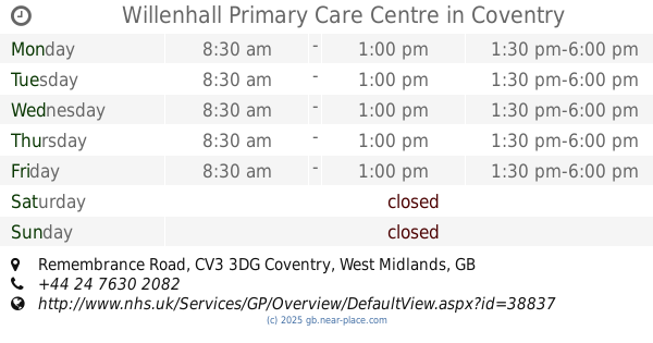
Willenhall Primary Care Centre
Remembrance Road, Coventry
Hospital
read more
4.443 km
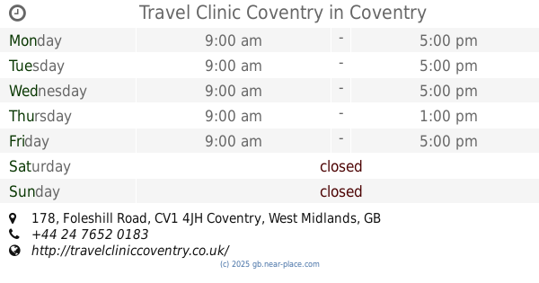
Travel Clinic Coventry
178 Foleshill Road, Coventry
Hospital
read more
4.616 km
Clay Lane Dialysis Unit
5 Clay Lane, Coventry
Hospital
read more
4.654 km
Wheelchair Services
Newfield Annexe, Community Mental Health, Coventry
Hospital
read more
4.939 km
Well-being, Gender & 4D Baby Scans Coventry - Window to the Womb
298 Walsgrave Road, Coventry
Hospital
read more
5.428 km
Warwickshire Dedicated Research Centre
42 Station Road, Kenilworth
Hospital
read more
5.429 km
Abbey Medical Centre
42 Station Road, Kenilworth
Hospital
read more
5.534 km
MedicSpot Clinic Coventry Allesley
132-134 Birmingham Road, Allesley, Coventry
Hospital
read more
5.633 km
Allesley Village Surgery
163 Birmingham Road, Allesley, Coventry
Hospital
read more
5.702 km
Life Line Screening
110 Warwick Road, Kenilworth
Hospital
read more
📑
all categories
Accounting
Administrative area level 1
Administrative area level 2
Airport
Amusement park
Aquarium
Art gallery
Atm
Bakery
Bank
Bar
Beauty salon
Bicycle store
Book store
Bowling alley
Bus station
Cafe
Campground
Car dealer
Car rental
Car repair
Car wash
Casino
Cemetery
Church
City hall
Clothing store
Colloquial area
Convenience store
Courthouse
Dentist
Department store
Doctor
Electrician
Electronics store
Embassy
Establishment
Finance
Fire station
Florist
Food
Funeral home
Furniture store
Gas station
General contractor
Grocery or supermarket
Gym
Hair care
Hardware store
Health
Hindu Temple
Home goods store
Hospital
Insurance agency
Jewelry store
Laundry
Lawyer
Library
Light rail station
Liquor store
Local government office
Locality
Locksmith
Lodging
Meal delivery
Meal takeaway
Mosque
Movie rental
Movie theater
Moving company
Museum
Natural feature
Neighborhood
Night club
Painter
Park
Parking
Pet store
Pharmacy
Physiotherapist
Place of worship
Plumber
Point of interest
Police
Political
Post office
Premise
Real estate agency
Restaurant
Roofing contractor
Route
Rv park, camping
School
Shoe store
Shopping mall
Spa
Stadium
Storage
Store
Subpremise
Subway station
Supermarket
Synagogue
Taxi stand
Train station
Transit station
Travel agency
University
Veterinary care
Zoo
administrative area level 3
administrative area level 4
sublocality level 1
↑