Library nearby Meir Library
Coronavirus disease (COVID-19) Situation
confirmed cases
24910387
deaths
232112
United Kingdom
Library nearby Meir Library
Meir Library
11 Sandon Road, Stoke-on-Trent Zjednoczone Królestwo
contacts phone
:
+44
Latitude:
52.9766228
, Longitude:
-2.1045526
read more
nearest Library
2.052 km
Longton Library
Sutherland Institute, Lightwood Road, Stoke-on-Trent
Library
read more
4.421 km
Bentilee Library
Bentilee Neighbourhood Centre, Dawlish Drive, Stoke-on-Trent
Library
read more
4.421 km
Bentilee Library
Bentilee Neighbourhood Centre/Dawlish Dr, Stoke-on-Trent
Library
read more
5.165 km
Werrington Library
Ash Bank Road, Werrington, Stoke-on-Trent
Library
read more
5.167 km
Your Library
362 Ash Bank Road, Werrington, Stoke-on-Trent
Library
read more
5.859 km
Law Library
Stoke-on-Trent
Library
read more
6.114 km
Stoke Library
Stoke Local Service Centre/South Wolfe St, Stoke-on-Trent
Library
read more
6.126 km
One Stop Shop, incl Stoke Library
65 Church Street, Stoke-on-Trent
Library
read more
6.346 km
Cadman Building
College Road, Stoke-on-Trent
Library
read more
6.381 km
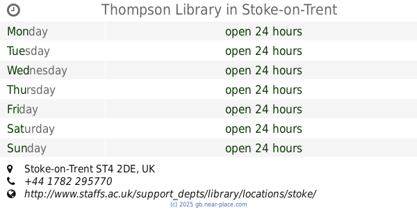
Thompson Library
Stoke-on-Trent
Library
read more
7.018 km
City Central Library
Bethesda Street, Stoke-on-Trent
Library
read more
7.755 km
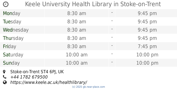
Keele University Health Library
Stoke-on-Trent
Library
read more
8.457 km
Clayton Library
12 Kingsbridge Avenue, Newcastle
Library
read more
9.036 km
Newcastle Library
47 Ironmarket, Newcastle
Library
read more
10.508 km
Haywood Community Library
Stoke-on-Trent
Library
read more
10.773 km
Knutton Library
Church Lane, Newcastle
Library
read more
11.525 km
Tunstall Library
Victoria Institute, The Boulevard
Library
read more
11.553 km
Keele University Library
Keele University, Newcastle
Library
read more
11.776 km
Silverdale Library
High St, Newcastle
Library
read more
11.794 km
Your Library
1 The Parade, Newcastle
Library
read more
15.71 km
Audley Library
Hall Street, Audley, Stoke-on-Trent
Library
read more
17.322 km
Holmcroft Library
Holmcroft Library/Holmcroft Rd, Stafford
Library
read more
32.965 km
Middlewich Library
22 Lewin Street, Middlewich
Library
read more
37.655 km
Lichfield Library
The Friary, Lichfield
Library
read more
62.225 km
Park Library Centre
243 Duke Street, Sheffield
Library
read more
📑
all categories
Accounting
Administrative area level 1
Administrative area level 2
Airport
Amusement park
Aquarium
Art gallery
Atm
Bakery
Bank
Bar
Beauty salon
Bicycle store
Book store
Bowling alley
Bus station
Cafe
Campground
Car dealer
Car rental
Car repair
Car wash
Casino
Cemetery
Church
City hall
Clothing store
Colloquial area
Convenience store
Courthouse
Dentist
Department store
Doctor
Electrician
Electronics store
Embassy
Establishment
Finance
Fire station
Florist
Food
Funeral home
Furniture store
Gas station
General contractor
Grocery or supermarket
Gym
Hair care
Hardware store
Health
Hindu Temple
Home goods store
Hospital
Insurance agency
Jewelry store
Laundry
Lawyer
Library
Light rail station
Liquor store
Local government office
Locality
Locksmith
Lodging
Meal delivery
Meal takeaway
Mosque
Movie rental
Movie theater
Moving company
Museum
Natural feature
Neighborhood
Night club
Painter
Park
Parking
Pet store
Pharmacy
Physiotherapist
Place of worship
Plumber
Point of interest
Police
Political
Post office
Premise
Real estate agency
Restaurant
Roofing contractor
Route
Rv park, camping
School
Shoe store
Shopping mall
Spa
Stadium
Storage
Store
Subpremise
Subway station
Supermarket
Synagogue
Taxi stand
Train station
Transit station
Travel agency
University
Veterinary care
Zoo
administrative area level 3
administrative area level 4
sublocality level 1
↑