Local government office nearby Andy Street
United Kingdom
Local government office nearby Andy Street
Andy Street
8 Greenfield Crescent, Birmingham Reino Unido
contacts phone
:
+44
Latitude:
52.4703303
, Longitude:
-1.9221585
read more
nearest Local government office
161 m
M&N HEALTHCARE
22, QUADRANT COURT, 48 Calthorpe Road, Birmingham
Local government office
read more
168 m
Acas Counselling Service
1112 Highfield Road, Birmingham
Local government office
read more
257 m
Heantun Housing Association
93 Hagley Road, Birmingham
Local government office
read more
357 m
Connaught Partners Ltd
123 Hagley Road, Birmingham
Local government office
read more
528 m
Executive Network Legal Ltd
7 George Road, Birmingham
Local government office
read more
677 m
Highways England
B15 1AY Broad Street, Birmingham
Local government office
read more
877 m
Patronato Acli
2 Calthorpe Rd, Birmingham
Local government office
read more
945 m
NHS Birmingham and Solihull CCG
142 Hagley Road, Birmingham
Local government office
read more
1.075 km
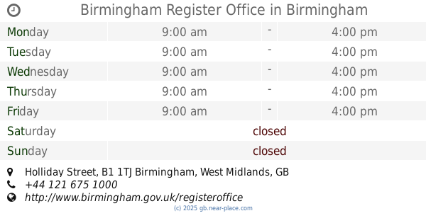
Birmingham Register Office
Holliday Street, Birmingham
Local government office
read more
1.271 km
Hsbc Headquarters
5 Bridge Street, Birmingham
Local government office
read more
1.364 km
Care Leavers Service
28 Acorn Grove, Birmingham
Local government office
read more
1.498 km
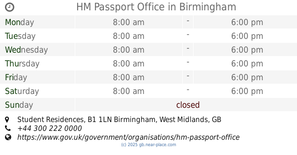
HM Passport Office
6TH floor, Suffolk Saint Queensway, Student Residences, Birmingham
Local government office
read more
1.498 km
Birmingham HM Passport Office
Suffolk Saint Queensway, 6 Student Residences, Birmingham
Local government office
read more
1.666 km
Friendship Care & Housing
50 Newhall Hill, Birmingham
Local government office
read more
1.722 km
Red Rock Consultants Ltd
21 Graham Street, Birmingham
Local government office
read more
1.724 km
Waterloo House
20 Waterloo Street, Birmingham
Local government office
read more
1.777 km
Axis Design Architects
28 George Street, Birmingham
Local government office
read more
1.807 km
Nationwide Construction Recruitment (Agency)
Cornwall Buildings, 45 Newhall Street, Birmingham
Local government office
read more
1.842 km
Occupational Health Service, Birmingham City Council
137 Newhall Street, Birmingham
Local government office
read more
2.013 km
BDP
158 Edmund Street, Birmingham
Local government office
read more
2.057 km
Node
Imperial & Whitehall, 23 Colmore Row, Birmingham
Local government office
read more
2.108 km
Safety Business Learning
Queensway House, 57 Livery Street, Birmingham
Local government office
read more
2.12 km
Fuller Long Planning Consultant - Birmingham
4th floor, Colmore Gate, 2-6, Colmore Row, Birmingham
Local government office
read more
2.258 km
West Midlands Police
West Midlands Police Headquarters Lloyd House Colmore Circus, Birmingham
Local government office
read more
2.372 km
Probation Service Victim Liaison Office
52 Newton Street, Birmingham
Local government office
read more
📑
all categories
Accounting
Administrative area level 1
Administrative area level 2
Airport
Amusement park
Aquarium
Art gallery
Atm
Bakery
Bank
Bar
Beauty salon
Bicycle store
Book store
Bowling alley
Bus station
Cafe
Campground
Car dealer
Car rental
Car repair
Car wash
Casino
Cemetery
Church
City hall
Clothing store
Colloquial area
Convenience store
Courthouse
Dentist
Department store
Doctor
Electrician
Electronics store
Embassy
Establishment
Finance
Fire station
Florist
Food
Funeral home
Furniture store
Gas station
General contractor
Grocery or supermarket
Gym
Hair care
Hardware store
Health
Hindu Temple
Home goods store
Hospital
Insurance agency
Jewelry store
Laundry
Lawyer
Library
Light rail station
Liquor store
Local government office
Locality
Locksmith
Lodging
Meal delivery
Meal takeaway
Mosque
Movie rental
Movie theater
Moving company
Museum
Natural feature
Neighborhood
Night club
Painter
Park
Parking
Pet store
Pharmacy
Physiotherapist
Place of worship
Plumber
Point of interest
Police
Political
Post office
Premise
Real estate agency
Restaurant
Roofing contractor
Route
Rv park, camping
School
Shoe store
Shopping mall
Spa
Stadium
Storage
Store
Subpremise
Subway station
Supermarket
Synagogue
Taxi stand
Train station
Transit station
Travel agency
University
Veterinary care
Zoo
administrative area level 3
administrative area level 4
sublocality level 1
↑