Local government office nearby HM Land Registry - Coventry Office
Coronavirus disease (COVID-19) Situation
confirmed cases
24910387
deaths
232112
United Kingdom
Local government office nearby HM Land Registry - Coventry Office
HM Land Registry - Coventry Office
53-55 Butts Road, Coventry United Kingdom
contacts phone
:
+44
Latitude:
52.4059936
, Longitude:
-1.5244
read more
nearest Local government office
443 m
BestStaff Ltd
Osbourne House, Queen Victoria Road, Coventry
Local government office
read more
651 m
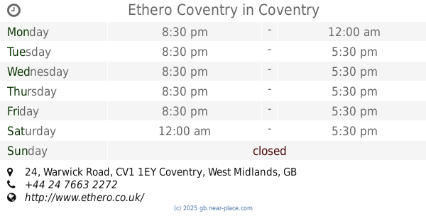
Ethero Coventry
24 Warwick Road, Coventry
Local government office
read more
869 m
Coventry City Council
One Friargate, Coventry
Local government office
read more
907 m
Pertemps Coventry Office and Professional
143 New Union Street, Coventry
Local government office
read more
912 m
Coroner's Office
Manor House Drive, Coventry
Local government office
read more
917 m
Broadgate House
Broadgate House, Broadgate, Coventry
Local government office
read more
1.038 km
ACAS
72-76 Earlsdon Street, Coventry
Local government office
read more
1.045 km
Infinity Staffing Solutions Ltd
Office 16 & 17, Palmer House, Palmer Lane, The Burges, Coventry, CV1 1FN, Coventry
Local government office
read more
1.124 km
Coventry City Council
Earl Street, Coventry
Local government office
read more
1.413 km
Nutshell Communications Ltd
The Technocentre, Puma Way, Coventry
Local government office
read more
1.88 km
Coventry Stop Smoking Service
Cov & Warks Hospital, Stoney Stanton Road, Coventry
Local government office
read more
2.221 km
Child Maintenance Service (CMS)
144 Broad Lane, Coventry
Local government office
read more
2.522 km
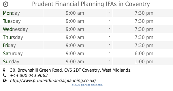
Prudent Financial Planning IFAs
30 Brownshill Green Road, Coventry
Local government office
read more
2.881 km
Social Services Radford Office
Telfer Road, Coventry
Local government office
read more
2.973 km
Coventry City Council
9 North Avenue, Coventry
Local government office
read more
4.637 km
Advanced Surveys Ltd
6 Allerton Close, Coventry
Local government office
read more
4.766 km
Coventry Fostering & Adoption Service
Stoke House, Lloyd Crescent, Coventry
Local government office
read more
5.857 km
Parcelforce National Hub
Middlemarch Business Park, Siskin Parkway West, Coventry
Local government office
read more
8.822 km
C P B Surveys Ltd
Furzen Hill Farm, Coventry Road, Cubbington, Leamington Spa
Local government office
read more
12.864 km
Village Hall
12 Church Street, Marton, Rugby
Local government office
read more
14.457 km
B S Breakwell optometrists
16 Jury Street, Warwick
Local government office
read more
14.46 km
PEBBLEWORTH RESOURCING LTD
7 OLD WARWICK SQUARE, WARWICK, WARWICKSHIRE
Local government office
read more
14.606 km
NHS Arden & GEM CSU
Westgate House, 21 Market Street, Warwick
Local government office
read more
16.787 km
Solihull Connect walk in centre
10 West Mall, Birmingham
Local government office
read more
18.111 km
Social Services
Bosworth Centre Auckland Drive, Birmingham
Local government office
read more
📑
all categories
Accounting
Administrative area level 1
Administrative area level 2
Airport
Amusement park
Aquarium
Art gallery
Atm
Bakery
Bank
Bar
Beauty salon
Bicycle store
Book store
Bowling alley
Bus station
Cafe
Campground
Car dealer
Car rental
Car repair
Car wash
Casino
Cemetery
Church
City hall
Clothing store
Colloquial area
Convenience store
Courthouse
Dentist
Department store
Doctor
Electrician
Electronics store
Embassy
Establishment
Finance
Fire station
Florist
Food
Funeral home
Furniture store
Gas station
General contractor
Grocery or supermarket
Gym
Hair care
Hardware store
Health
Hindu Temple
Home goods store
Hospital
Insurance agency
Jewelry store
Laundry
Lawyer
Library
Light rail station
Liquor store
Local government office
Locality
Locksmith
Lodging
Meal delivery
Meal takeaway
Mosque
Movie rental
Movie theater
Moving company
Museum
Natural feature
Neighborhood
Night club
Painter
Park
Parking
Pet store
Pharmacy
Physiotherapist
Place of worship
Plumber
Point of interest
Police
Political
Post office
Premise
Real estate agency
Restaurant
Roofing contractor
Route
Rv park, camping
School
Shoe store
Shopping mall
Spa
Stadium
Storage
Store
Subpremise
Subway station
Supermarket
Synagogue
Taxi stand
Train station
Transit station
Travel agency
University
Veterinary care
Zoo
administrative area level 3
administrative area level 4
sublocality level 1
↑