Local government office nearby Luff Peter
Coronavirus disease (COVID-19) Situation
confirmed cases
24910387
deaths
232112
United Kingdom
Local government office nearby Luff Peter
Luff Peter
15 Sansome Place, Worcester United Kingdom
contacts phone
:
+44
Latitude:
52.195303
, Longitude:
-2.218197
read more
nearest Local government office
151 m
B B Architecture & Planning
Sansome Lodge, 4 Sansome Walk, Worcester
Local government office
read more
330 m
Academic Solutions UK Ltd
County House, Saint Mary's Street, Worcester
Local government office
read more
1.084 km
Bath Road Project
47B Bath Road, Worcester
Local government office
read more
2.297 km
Parkwood Consultancy Services
Attwood House, John Comyn Drive, Worcester
Local government office
read more
2.566 km
Registration of Births Deaths & Marriages
Charles Hastings Way, Worcester
Local government office
read more
2.748 km
HMRC
1 Charles Hastings Way, Worcester
Local government office
read more
2.923 km
Early Help Hub-worcestershire County Council
Wildwood Drive, Worcester
Local government office
read more
2.971 km
NHS Worcestershire
Wildwood, Ground Floor, West Wing, Wildwood Drive, Worcester
Local government office
read more
4.444 km
Hindlip Hall
Hindlip Hall, Hindlip, Worcester
Local government office
read more
33.021 km
Dudley Council Housing Services
Harbour Buildings Waterfront West, Dudley Road, Brierley Hill
Local government office
read more
34.392 km
Doocey Traffic Management
10/11, Waterside Industrial Estate, Doulton Road, Cradley Heath, Rowley Regis
Local government office
read more
36.579 km
Gloucestershire NHS Stop Smoking Clinic
Gloucester Royal Hospital, Great Western Road, Gloucester
Local government office
read more
36.637 km
Shire Hall
Quayside House Shire Hall, Westgate Street, Gloucester
Local government office
read more
37.26 km
Highways England
B15 1AY Broad Street, Birmingham
Local government office
read more
37.836 km
Hsbc Headquarters
5 Bridge Street, Birmingham
Local government office
read more
38.697 km
Health Protection Agency
1270 The Square, Gloucester
Local government office
read more
38.732 km
Hucclecote Parish Council
Pineholt Village Hall, Bird Road, Gloucester
Local government office
read more
39.664 km
Acas Counselling Service
235 Bridge Street West, Birmingham
Local government office
read more
41.681 km
Sandwell Local, Wednesbury
Town Hall,, Lower High Street, Wednesbury
Local government office
read more
41.868 km
Working Tax Credit
1 Railway Terrace, Wednesbury
Local government office
read more
43.606 km
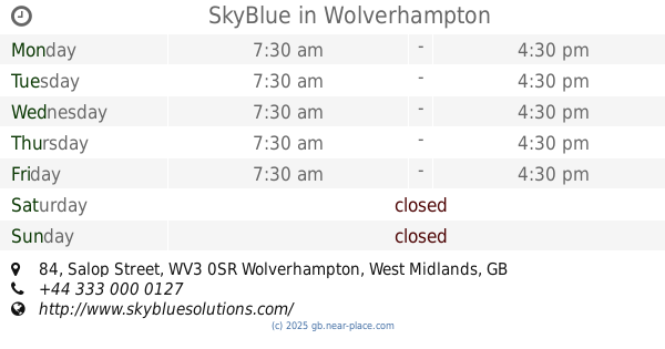
SkyBlue
Carillion House, 84 Salop Street, Wolverhampton
Local government office
read more
43.829 km
Wolverhampton City Council - Carer Support
9 North Street, Wolverhampton
Local government office
read more
45.267 km
Self-serve grit bin
Albion Road, Willenhall
Local government office
read more
46.939 km
Social Services
Bosworth Centre Auckland Drive, Birmingham
Local government office
read more
50.725 km
Child Maintenance Service (CMS)
144 Broad Lane, Coventry
Local government office
read more
📑
all categories
Accounting
Administrative area level 1
Administrative area level 2
Airport
Amusement park
Aquarium
Art gallery
Atm
Bakery
Bank
Bar
Beauty salon
Bicycle store
Book store
Bowling alley
Bus station
Cafe
Campground
Car dealer
Car rental
Car repair
Car wash
Casino
Cemetery
Church
City hall
Clothing store
Colloquial area
Convenience store
Courthouse
Dentist
Department store
Doctor
Electrician
Electronics store
Embassy
Establishment
Finance
Fire station
Florist
Food
Funeral home
Furniture store
Gas station
General contractor
Grocery or supermarket
Gym
Hair care
Hardware store
Health
Hindu Temple
Home goods store
Hospital
Insurance agency
Jewelry store
Laundry
Lawyer
Library
Light rail station
Liquor store
Local government office
Locality
Locksmith
Lodging
Meal delivery
Meal takeaway
Mosque
Movie rental
Movie theater
Moving company
Museum
Natural feature
Neighborhood
Night club
Painter
Park
Parking
Pet store
Pharmacy
Physiotherapist
Place of worship
Plumber
Point of interest
Police
Political
Post office
Premise
Real estate agency
Restaurant
Roofing contractor
Route
Rv park, camping
School
Shoe store
Shopping mall
Spa
Stadium
Storage
Store
Subpremise
Subway station
Supermarket
Synagogue
Taxi stand
Train station
Transit station
Travel agency
University
Veterinary care
Zoo
administrative area level 3
administrative area level 4
sublocality level 1
↑