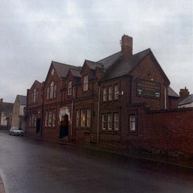
Mosque nearby Farooq E Azam Mosque & Islamic Centre
Coronavirus disease (COVID-19) Situation
confirmed cases
24910387
deaths
232112
United Kingdom
Mosque nearby Farooq E Azam Mosque & Islamic Centre
Farooq E Azam Mosque & Islamic Centre
Bowesfield Lane, Stockton-on-Tees United Kingdom
contacts phone
:
+44
Latitude:
54.5596243
, Longitude:
-1.3184144
read more
nearest Mosque
328 m
Jamia Al Bilal Mosque
30-32 Yarm Road, Stockton-on-Tees
Mosque
read more
355 m
Central Mosque & Islamic Centre
37 Hartington Road, Stockton-on-Tees
Mosque
read more
1.466 km
Thornaby Muslim Association & Mosque
127-, 129 Westbury Street, Thornaby, Stockton-on-Tees
Mosque
read more
3.629 km
Ahel El Beit Islamic Center
Middlesbrough
Mosque
read more
4.315 km
Al-Mustafa Centre
Parliament Road, Middlesbrough
Mosque
read more
4.901 km
New Abu Bakr Mosque
28-4 Cannon Park Way, Middlesbrough
Mosque
read more
5.169 km
The Abu Bakr Mosque and Cultural Centre
7-9 Park Road North, Middlesbrough
Mosque
read more
5.195 km
مسجد عربي
18 Park Road North, Middlesbrough
Mosque
read more
5.206 km
Hussainiat Al Zahra
Middlesbrough, 8 Harris Street, Middlesbrough
Mosque
read more
5.24 km
Masjid-E-Ali Ibn Abu Talib
11 Granville Road, Middlesbrough
Mosque
read more
5.707 km
Jamia Masjid Al-Madina Middlesbrough
133A Waterloo Road, Middlesbrough
Mosque
read more
5.754 km
Middlesbrough Central Mosque
30 Southfield Road, Middlesbrough
Mosque
read more
9.278 km
Masjid-E-Nomira
United Kingdom
Mosque
read more
28.862 km
Durham Islamic Society Mosque
The Dun Cow, Old Elvet, Durham
Mosque
read more
38.256 km
Hendon Jame Masjid
6 Laura Street, Sunderland
Mosque
read more
38.462 km
Sunderland Central Mosque
73-75 Chester Road, Sunderland
Mosque
read more
38.855 km
Sunderland Mosque
Saint Mark's Road North, Sunderland
Mosque
read more
47.748 km
Shah Jalal Masjid and Islamic Cultural Centre
141 Coatsworth Road, Gateshead
Mosque
read more
47.79 km
Al-Furqan Mosque
2 Villa Place, Gateshead
Mosque
read more
49.983 km
Newcastle Central Mosque Islamic Centre (Bilal Jamia Masjid)
Malvern Street, Newcastle upon Tyne
Mosque
read more
50.037 km
Bangladesh Islamic Centre Newcastle upon Tyne
246 Elswick Road, Newcastle upon Tyne
Mosque
read more
50.047 km
Newcastle Central Mosque
Malvern Street, Newcastle upon Tyne
Mosque
read more
50.158 km
Shah Jalal Mosque Newcastle upon Tyne
26 Sceptre Street, Newcastle upon Tyne
Mosque
read more
50.193 km
masjid
109 Bentinck Road, Newcastle upon Tyne
Mosque
read more
50.294 km
The Heaton Mosque & Islamic Centre
1 Rothbury Terrace, Newcastle upon Tyne
Mosque
read more
📑
all categories
Accounting
Administrative area level 1
Administrative area level 2
Airport
Amusement park
Aquarium
Art gallery
Atm
Bakery
Bank
Bar
Beauty salon
Bicycle store
Book store
Bowling alley
Bus station
Cafe
Campground
Car dealer
Car rental
Car repair
Car wash
Casino
Cemetery
Church
City hall
Clothing store
Colloquial area
Convenience store
Courthouse
Dentist
Department store
Doctor
Electrician
Electronics store
Embassy
Establishment
Finance
Fire station
Florist
Food
Funeral home
Furniture store
Gas station
General contractor
Grocery or supermarket
Gym
Hair care
Hardware store
Health
Hindu Temple
Home goods store
Hospital
Insurance agency
Jewelry store
Laundry
Lawyer
Library
Light rail station
Liquor store
Local government office
Locality
Locksmith
Lodging
Meal delivery
Meal takeaway
Mosque
Movie rental
Movie theater
Moving company
Museum
Natural feature
Neighborhood
Night club
Painter
Park
Parking
Pet store
Pharmacy
Physiotherapist
Place of worship
Plumber
Point of interest
Police
Political
Post office
Premise
Real estate agency
Restaurant
Roofing contractor
Route
Rv park, camping
School
Shoe store
Shopping mall
Spa
Stadium
Storage
Store
Subpremise
Subway station
Supermarket
Synagogue
Taxi stand
Train station
Transit station
Travel agency
University
Veterinary care
Zoo
administrative area level 3
administrative area level 4
sublocality level 1
↑