Night club nearby 2K's Shisha Lounge
Coronavirus disease (COVID-19) Situation
confirmed cases
24910387
deaths
232112
United Kingdom
Night club nearby 2K's Shisha Lounge
2K's Shisha Lounge
71 New Broadway, London United Kingdom
contacts phone
:
+44
Latitude:
51.5125305
, Longitude:
-0.3080675
read more
nearest Night club
252 m
Karma Ealing
10 High Street, London
Night club
read more
445 m
The Red Room
42A The Broadway, London
Night club
read more
2.031 km
fortus security
86 Uxbridge Road, London
Night club
read more
2.103 km
BIURO
17 Boston Road, London
Night club
read more
2.47 km
London star lounge
51-53 Steyne Road, London
Night club
read more
2.723 km
Nai Lounge
40 Bideford Avenue, Perivale, Greenford
Night club
read more
2.926 km
Area-56 Ltd
56 Fraser Road, Greenford
Night club
read more
3.278 km
Casablanca Lounge
181 Ealing Road, Wembley
Night club
read more
3.289 km
Linkup Lounge
52 Greenford Road, Greenford
Night club
read more
3.402 km
Psy
708D Abbey Road, London
Night club
read more
3.686 km
Istvan Benke
Templemead Close, London
Night club
read more
3.814 km
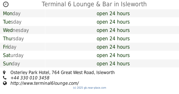
Terminal 6 Lounge & Bar
Osterley Park Hotel, 764 Great West Road, Isleworth
Night club
read more
4.291 km
Aarti Indian Musical Group
Ealing Road, Wembley
Night club
read more
4.372 km
Customer delivery
Chiswick, Unnamed Road, London
Night club
read more
4.419 km
Askew Pub & Kitchen
Askew Arms, 269 Uxbridge Road, London
Night club
read more
4.451 km
Masti
572-582 High Road, Wembley
Night club
read more
4.491 km
Horrow
558 Market Way, Wembley
Night club
read more
4.568 km
Victoria House
61 Becklow Gardens, London
Night club
read more
5.049 km
Vauxhall garage
30 North Road, Richmond
Night club
read more
5.204 km
Club Jetset
250 High Street, London
Night club
read more
5.243 km
Mangos Wembley - Bar - Shisha - Dinner & Club
1 Poppin Business Centre, South Way, Wembley
Night club
read more
5.328 km
Geminvest London Limited
Chandelier Building, 8 Scrubs Lane, London
Night club
read more
5.677 km
Randall Court
Dairy Close, London
Night club
read more
6.109 km
London Apollo Club
375 High Road, London
Night club
read more
6.325 km
Club K
236a High Street, Hounslow
Night club
read more
📑
all categories
Accounting
Administrative area level 1
Administrative area level 2
Airport
Amusement park
Aquarium
Art gallery
Atm
Bakery
Bank
Bar
Beauty salon
Bicycle store
Book store
Bowling alley
Bus station
Cafe
Campground
Car dealer
Car rental
Car repair
Car wash
Casino
Cemetery
Church
City hall
Clothing store
Colloquial area
Convenience store
Courthouse
Dentist
Department store
Doctor
Electrician
Electronics store
Embassy
Establishment
Finance
Fire station
Florist
Food
Funeral home
Furniture store
Gas station
General contractor
Grocery or supermarket
Gym
Hair care
Hardware store
Health
Hindu Temple
Home goods store
Hospital
Insurance agency
Jewelry store
Laundry
Lawyer
Library
Light rail station
Liquor store
Local government office
Locality
Locksmith
Lodging
Meal delivery
Meal takeaway
Mosque
Movie rental
Movie theater
Moving company
Museum
Natural feature
Neighborhood
Night club
Painter
Park
Parking
Pet store
Pharmacy
Physiotherapist
Place of worship
Plumber
Point of interest
Police
Political
Post office
Premise
Real estate agency
Restaurant
Roofing contractor
Route
Rv park, camping
School
Shoe store
Shopping mall
Spa
Stadium
Storage
Store
Subpremise
Subway station
Supermarket
Synagogue
Taxi stand
Train station
Transit station
Travel agency
University
Veterinary care
Zoo
administrative area level 3
administrative area level 4
sublocality level 1
↑