Night club nearby Jazz in Birmingham
Coronavirus disease (COVID-19) Situation
confirmed cases
24910387
deaths
232112
United Kingdom
Night club nearby Jazz in Birmingham
Jazz in Birmingham
112 Gaia Lane, Lichfield United Kingdom
contacts phone
:
+44
Latitude:
52.6890546
, Longitude:
-1.8260499
read more
nearest Night club
4.905 km
DC Karaoke & Disco
15 Greenways, Chorley, Lichfield
Night club
read more
7.602 km
Spice Lounge
1a High Street, Chasetown, Burntwood
Night club
read more
8.849 km
CentrePointe Academy of Dance
Brereton & Ravenhill Community Centre, Ravenhill Park, Main Road, Rugeley
Night club
read more
13.459 km
Wongle Tongle
32 Rectory Road, Sutton Coldfield
Night club
read more
15.357 km
Equator
132 Lichfield Street, Walsall
Night club
read more
15.386 km
Manhattan's
133 Lichfield Street, Walsall
Night club
read more
15.573 km
Yates
23-29 Leicester Street, Walsall
Night club
read more
15.606 km
Artisan Vapor Company Walsall
21 Bridge Street, Walsall
Night club
read more
16.043 km
Dream Blue Grill, Dessert & Shisha Lounge
40 Bradford Street, Walsall
Night club
read more
16.218 km
Bel Air Night Club & Lounge
The Belfry Hotel & Resort, Lichfield Road, Wishaw
Night club
read more
17.885 km
PerfectSoundswm
Flat 2, Short Heath Court 1 Short Heath Road, Birmingham
Night club
read more
18.496 km
Club Maragh
197 High Street, Birmingham
Night club
read more
20.815 km
I
Bromford Road, Birmingham
Night club
read more
23.183 km
Outback Wolverhampton
50 Queen Street, Wolverhampton
Night club
read more
23.257 km
Warstone centre
154 Warstone Lane, Birmingham
Night club
read more
23.431 km
Vocalise Entertainment
57 Tempest Street, Wolverhampton
Night club
read more
23.79 km
Starworks Warehouse Wolverhampton
Frederick Street, Wolverhampton
Night club
read more
24.253 km
Sobar
86 Hurst Street, Birmingham
Night club
read more
24.306 km
Indi Vidual Bar Birmingham
The Arcadian Centre, Hurst Street, Birmingham
Night club
read more
24.313 km
Cvhjdjsbsbsbsnz
12-1 Ermington Road, Wolverhampton
Night club
read more
24.351 km
Nuvo
Eleven Brindley Place, 2 Brunswick Square, Birmingham
Night club
read more
24.513 km
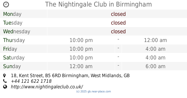
The Nightingale Club
18 Kent Street, Birmingham
Night club
read more
24.554 km
Legs 11 Broad Street
193-194 Broad Street, Birmingham
Night club
read more
24.638 km
Stus
112 Upper Villiers Street, Wolverhampton
Night club
read more
34.42 km
The Attic Adult Club & Photographic Studio
270 Osmaston Road, Derby
Night club
read more
📑
all categories
Accounting
Administrative area level 1
Administrative area level 2
Airport
Amusement park
Aquarium
Art gallery
Atm
Bakery
Bank
Bar
Beauty salon
Bicycle store
Book store
Bowling alley
Bus station
Cafe
Campground
Car dealer
Car rental
Car repair
Car wash
Casino
Cemetery
Church
City hall
Clothing store
Colloquial area
Convenience store
Courthouse
Dentist
Department store
Doctor
Electrician
Electronics store
Embassy
Establishment
Finance
Fire station
Florist
Food
Funeral home
Furniture store
Gas station
General contractor
Grocery or supermarket
Gym
Hair care
Hardware store
Health
Hindu Temple
Home goods store
Hospital
Insurance agency
Jewelry store
Laundry
Lawyer
Library
Light rail station
Liquor store
Local government office
Locality
Locksmith
Lodging
Meal delivery
Meal takeaway
Mosque
Movie rental
Movie theater
Moving company
Museum
Natural feature
Neighborhood
Night club
Painter
Park
Parking
Pet store
Pharmacy
Physiotherapist
Place of worship
Plumber
Point of interest
Police
Political
Post office
Premise
Real estate agency
Restaurant
Roofing contractor
Route
Rv park, camping
School
Shoe store
Shopping mall
Spa
Stadium
Storage
Store
Subpremise
Subway station
Supermarket
Synagogue
Taxi stand
Train station
Transit station
Travel agency
University
Veterinary care
Zoo
administrative area level 3
administrative area level 4
sublocality level 1
↑