Premise nearby Lambeth Palace
Coronavirus disease (COVID-19) Situation
confirmed cases
24910387
deaths
232112
United Kingdom
Premise nearby Lambeth Palace
Lambeth Palace
London Zjednoczone Królestwo
contacts phone
:
+44
Latitude:
51.4957797
, Longitude:
-0.1198461
read more
nearest Premise
352 m
St. Thomas' Campus
Zjednoczone Królestwo
Premise
read more
411 m
North Wing
Det Forenede Kongerige
Premise
read more
515 m
Black Prince Community Hub
United Kingdom
Premise
read more
515 m
Black Prince Community Hub
Reino Unido
Premise
read more
515 m
Black Prince Community Hub
Det Forenede Kongerige
Premise
read more
525 m
Saint Olaves Gardens
Zjednoczone Królestwo
Premise
read more
525 m
Saint Olaves Gardens
Reino Unido
Premise
read more
536 m
Palace of Westminster
London
Premise
read more
536 m
Westminster Palace
London
Premise
read more
552 m
Lambeth Towers
Det Forenede Kongerige
Premise
read more
670 m
Westminster Abbey
Vereinigtes Königreich
Premise
read more
670 m
Westminster Abbey
Reino Unido
Premise
read more
681 m
Brittany Point
Reino Unido
Premise
read more
754 m
Edric House
United Kingdom
Premise
read more
762 m
Wogen Group Ltd
United Kingdom
Premise
read more
766 m
Crimea and Indian Mutiny Memorial
United Kingdom
Premise
read more
766 m
Peninsula Heights
Det Forenede Kongerige
Premise
read more
936 m
Dryden Court
Zjednoczone Królestwo
Premise
read more
982 m
London And South Western Railway Arch
Reino Unido
Premise
read more
1000 m
Eccles Court
Zjednoczone Królestwo
Premise
read more
1000 m
Eccles Court
Det Forenede Kongerige
Premise
read more
1.002 km
Hurley House
Vereinigtes Königreich
Premise
read more
1.02 km
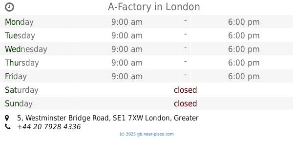
A-Factory
5 Westminster Bridge Road, London
Premise
read more
1.031 km
Fairford House
Zjednoczone Królestwo
Premise
read more
1.068 km
The Banqueting House
Reino Unido
Premise
read more
📑
all categories
Accounting
Administrative area level 1
Administrative area level 2
Airport
Amusement park
Aquarium
Art gallery
Atm
Bakery
Bank
Bar
Beauty salon
Bicycle store
Book store
Bowling alley
Bus station
Cafe
Campground
Car dealer
Car rental
Car repair
Car wash
Casino
Cemetery
Church
City hall
Clothing store
Colloquial area
Convenience store
Courthouse
Dentist
Department store
Doctor
Electrician
Electronics store
Embassy
Establishment
Finance
Fire station
Florist
Food
Funeral home
Furniture store
Gas station
General contractor
Grocery or supermarket
Gym
Hair care
Hardware store
Health
Hindu Temple
Home goods store
Hospital
Insurance agency
Jewelry store
Laundry
Lawyer
Library
Light rail station
Liquor store
Local government office
Locality
Locksmith
Lodging
Meal delivery
Meal takeaway
Mosque
Movie rental
Movie theater
Moving company
Museum
Natural feature
Neighborhood
Night club
Painter
Park
Parking
Pet store
Pharmacy
Physiotherapist
Place of worship
Plumber
Point of interest
Police
Political
Post office
Premise
Real estate agency
Restaurant
Roofing contractor
Route
Rv park, camping
School
Shoe store
Shopping mall
Spa
Stadium
Storage
Store
Subpremise
Subway station
Supermarket
Synagogue
Taxi stand
Train station
Transit station
Travel agency
University
Veterinary care
Zoo
administrative area level 3
administrative area level 4
sublocality level 1
↑