Supermarket nearby ALDI
United Kingdom
Supermarket nearby ALDI
ALDI
Stanningley Road, Leeds United Kingdom
contacts phone
:
+44
Latitude:
53.8058647
, Longitude:
-1.6250515
read more
nearest Supermarket
630 m
Tesco Superstore
22 Bramley Centre, Bramley, Leeds
Supermarket
read more
630 m
Tesco Superstore
22 Waterloo Terrace, Leeds
Supermarket
read more
676 m
Fultons Foods
28-29, Bramley District Center, Leeds
Supermarket
read more
711 m
Farmfoods Ltd
2 Waterloo Terrace, Leeds, Bramley
Supermarket
read more
778 m
Morrisons
Swinnow Road, Leeds
Supermarket
read more
1.119 km
Spar Supermarket
Leeds
Supermarket
read more
1.121 km
Spar Supermarket
Broad Ln, Leeds
Supermarket
read more
1.121 km
Spar Supermarket
Bramley, Leeds
Supermarket
read more
1.171 km
Heron Foods
3 Butt Lane, Leeds
Supermarket
read more
1.194 km
Nisa
306 Broad La, Leeds
Supermarket
read more
1.586 km
Sainsbury's Local
37-39 Ring Road, Farnley, Leeds
Supermarket
read more
1.716 km
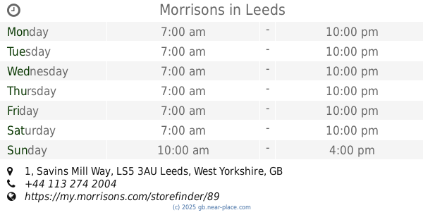
Morrisons
1 Savins Mill Way, Leeds
Supermarket
read more
1.792 km
The Food Warehouse by Iceland
6, B6157, Leeds
Supermarket
read more
1.792 km
The Food Warehouse by Iceland
6, Kirkstall Food Warehouse, B6157, Leeds
Supermarket
read more
1.792 km
The Food Warehouse by Iceland
Unit 6, Kirkstall Food Warehouse, Leeds
Supermarket
read more
1.919 km
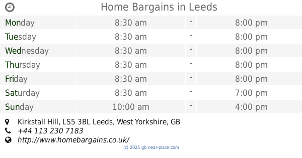
Home Bargains
Shopping Park, Kirkstall Hill
Supermarket
read more
2.382 km
Lidl
Pudsey
Supermarket
read more
2.44 km
B&M Express
Stanningley, Unit 3 Belgrave Retail Park
Supermarket
read more
2.442 km
Lidl Stanningley
Town Street
Supermarket
read more
2.51 km
Iceland Foods
2, Kirkstall Road, West Yorkshire, Leeds
Supermarket
read more
2.697 km
ALDI Burley, Leeds
Evanston Avenue, Burley, Leeds
Supermarket
read more
2.826 km
Fultons Foods
33 Church Lane, Pudsey
Supermarket
read more
3.213 km
Asda Wortley Oldfield Lane Supermarket
Oldfield Lane, Leeds
Supermarket
read more
3.213 km
Macro
Whitehall Road East, Leeds
Supermarket
read more
3.633 km
Premier Dixon Lane Convenience Store
110A Dixon Lane, Leeds
Supermarket
read more
📑
all categories
Accounting
Administrative area level 1
Administrative area level 2
Airport
Amusement park
Aquarium
Art gallery
Atm
Bakery
Bank
Bar
Beauty salon
Bicycle store
Book store
Bowling alley
Bus station
Cafe
Campground
Car dealer
Car rental
Car repair
Car wash
Casino
Cemetery
Church
City hall
Clothing store
Colloquial area
Convenience store
Courthouse
Dentist
Department store
Doctor
Electrician
Electronics store
Embassy
Establishment
Finance
Fire station
Florist
Food
Funeral home
Furniture store
Gas station
General contractor
Grocery or supermarket
Gym
Hair care
Hardware store
Health
Hindu Temple
Home goods store
Hospital
Insurance agency
Jewelry store
Laundry
Lawyer
Library
Light rail station
Liquor store
Local government office
Locality
Locksmith
Lodging
Meal delivery
Meal takeaway
Mosque
Movie rental
Movie theater
Moving company
Museum
Natural feature
Neighborhood
Night club
Painter
Park
Parking
Pet store
Pharmacy
Physiotherapist
Place of worship
Plumber
Point of interest
Police
Political
Post office
Premise
Real estate agency
Restaurant
Roofing contractor
Route
Rv park, camping
School
Shoe store
Shopping mall
Spa
Stadium
Storage
Store
Subpremise
Subway station
Supermarket
Synagogue
Taxi stand
Train station
Transit station
Travel agency
University
Veterinary care
Zoo
administrative area level 3
administrative area level 4
sublocality level 1
↑