Supermarket nearby Co-op Food
Coronavirus disease (COVID-19) Situation
confirmed cases
24910387
deaths
232112
United Kingdom
Supermarket nearby Co-op Food
Co-op Food
116 Swan Street, Sible Hedingham, Halstead United Kingdom
contacts phone
:
+44
Latitude:
51.9764982
, Longitude:
0.5931341
read more
nearest Supermarket
27 m
Darkins Supply Stores D I Y
122 Swan Street, Sible Hedingham, Halstead
Supermarket
read more
144 m
Londis
140 Swan Street, Sible Hedingham, Halstead
Supermarket
read more
11.546 km
Waitrose
Station Road, Sudbury
Supermarket
read more
11.787 km
Iceland Foods
94 North Street, Sudbury
Supermarket
read more
11.852 km
Aldi
Girling Street, Sudbury
Supermarket
read more
12.089 km
Sainsbury's
66, Great Cornard, Sudbury
Supermarket
read more
12.82 km
Tesco Superstore
Woodhall Business Park, Springlands Way, Sudbury
Supermarket
read more
18.941 km
Morrisons
99 Braintree Road, Witham
Supermarket
read more
19.666 km
Asda Witham Highfields Road Supermarket
24 Highfields Road, Witham
Supermarket
read more
19.873 km
Iceland Foods
The Newlands Precinct, Newlands Drive, Witham
Supermarket
read more
20.005 km
Tesco Superstore
1 The Grove Centre, Witham
Supermarket
read more
21.089 km
ALDI Witham
Reid Road, Witham
Supermarket
read more
23.341 km
Argos Colchester Town Centre
2, 17 Long Wyre Street, Colchester
Supermarket
read more
23.582 km
Great Totham Stores
7 Maldon Road, Great Totham, Maldon
Supermarket
read more
24.184 km
Village Store
Main Road, Boreham, Chelmsford
Supermarket
read more
24.795 km
Costcutter
41-45 High Street, Saffron Walden
Supermarket
read more
24.947 km
Sainsburys Local Springfield
51 Centenary Way, Chelmsford
Supermarket
read more
25.504 km
Sainsbury's
White Hart Lane, Chelmsford
Supermarket
read more
26.596 km
Morrisons
830 Dickens Place, Chelmsford
Supermarket
read more
36.247 km
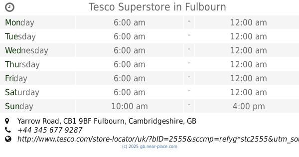
Tesco Superstore
Yarrow Road, Fulbourn, Cambridge
Supermarket
read more
57.338 km
Londis
5 Redbridge Lane East, Ilford
Supermarket
read more
57.922 km
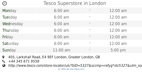
Tesco Superstore
405 Larkshall Road, London
Supermarket
read more
61.271 km
Tesco Express
567 569 High Rd, Leytonstone, London
Supermarket
read more
61.538 km
Rodi Supermarket
168 Queens Road, London
Supermarket
read more
63.212 km
Market Village at Stratford Shopping Centre
Stratford Centre The Mall 70-73 The Mall Stratford shopping centre, London
Supermarket
read more
📑
all categories
Accounting
Administrative area level 1
Administrative area level 2
Airport
Amusement park
Aquarium
Art gallery
Atm
Bakery
Bank
Bar
Beauty salon
Bicycle store
Book store
Bowling alley
Bus station
Cafe
Campground
Car dealer
Car rental
Car repair
Car wash
Casino
Cemetery
Church
City hall
Clothing store
Colloquial area
Convenience store
Courthouse
Dentist
Department store
Doctor
Electrician
Electronics store
Embassy
Establishment
Finance
Fire station
Florist
Food
Funeral home
Furniture store
Gas station
General contractor
Grocery or supermarket
Gym
Hair care
Hardware store
Health
Hindu Temple
Home goods store
Hospital
Insurance agency
Jewelry store
Laundry
Lawyer
Library
Light rail station
Liquor store
Local government office
Locality
Locksmith
Lodging
Meal delivery
Meal takeaway
Mosque
Movie rental
Movie theater
Moving company
Museum
Natural feature
Neighborhood
Night club
Painter
Park
Parking
Pet store
Pharmacy
Physiotherapist
Place of worship
Plumber
Point of interest
Police
Political
Post office
Premise
Real estate agency
Restaurant
Roofing contractor
Route
Rv park, camping
School
Shoe store
Shopping mall
Spa
Stadium
Storage
Store
Subpremise
Subway station
Supermarket
Synagogue
Taxi stand
Train station
Transit station
Travel agency
University
Veterinary care
Zoo
administrative area level 3
administrative area level 4
sublocality level 1
↑