Supermarket nearby Co-op Food - Norwich - Earlham Road
United Kingdom
Supermarket nearby Co-op Food - Norwich - Earlham Road
Co-op Food - Norwich - Earlham Road
Earlham Road, Norwich Zjednoczone Królestwo
contacts phone
:
+44
Latitude:
52.6290988
, Longitude:
1.2692697
read more
nearest Supermarket
44 m
Hong Ye Chinese Supermarket
Earlham House Shopping Centre, Earlham Road, Norwich
Supermarket
read more
785 m
Tesco Express
84 Unthank Road, Norwich
Supermarket
read more
824 m
Tesco Express
131 Dereham Road, Norwich
Supermarket
read more
931 m
Shopper Supermarket
3-5 Distillery Square, Norwich
Supermarket
read more
939 m
Spice Land
65 Dereham Road, Norwich
Supermarket
read more
967 m
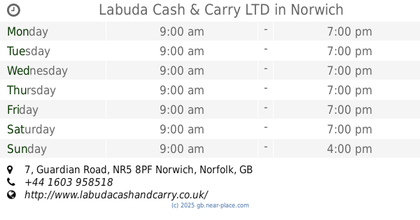
Labuda Cash & Carry LTD
8PF,, 7 Guardian Road, Norwich
Supermarket
read more
1.272 km
Farmfoods Ltd
67-69 Westwick Street, Norwich
Supermarket
read more
1.44 km
Tesco Express
Tesco Express Earlham Road, Earlham Road, Norwich
Supermarket
read more
1.44 km
Tesco Express
Tesco Express Earlham, Earlham Road, Norwich
Supermarket
read more
1.571 km
Iceland Foods
67-73 Saint Stephens Street, Norwich
Supermarket
read more
1.588 km
Tesco Metro
5 Guildhall Hill, Norwich
Supermarket
read more
1.729 km
Tesco Express
2-8 Westlegate, Norwich
Supermarket
read more
1.744 km
Tesco Express
79 Grove Road, Norwich
Supermarket
read more
1.803 km
Sainsbury's
1 Brazen Gate, Norwich
Supermarket
read more
1.804 km
Lidl
Drayton Road, Norwich
Supermarket
read more
1.804 km
Lidl Norwich
Drayton Road, Norwich
Supermarket
read more
1.912 km
Drayton Road Stores LTD
185 Drayton Road, Norwich
Supermarket
read more
1.917 km
Iceland Foods
Units 1/3, Anglia Square
Supermarket
read more
2.011 km
Desh Cash & Carry
100 Magdalen Street, Norwich
Supermarket
read more
2.156 km
ALDI
1 Larkman Lane, Norwich
Supermarket
read more
2.196 km
Tesco Express
40A Magdalen Road, Norwich
Supermarket
read more
2.226 km
Plus Ltd
57 Hall Road, Norwich
Supermarket
read more
2.246 km
Co-op Food
110 Hall Road, Norwich
Supermarket
read more
2.294 km
Costcutter
55-57 Magdalen Road, Norwich
Supermarket
read more
2.493 km
Lidl Norwich
Aylsham Road, Norwich
Supermarket
read more
📑
all categories
Accounting
Administrative area level 1
Administrative area level 2
Airport
Amusement park
Aquarium
Art gallery
Atm
Bakery
Bank
Bar
Beauty salon
Bicycle store
Book store
Bowling alley
Bus station
Cafe
Campground
Car dealer
Car rental
Car repair
Car wash
Casino
Cemetery
Church
City hall
Clothing store
Colloquial area
Convenience store
Courthouse
Dentist
Department store
Doctor
Electrician
Electronics store
Embassy
Establishment
Finance
Fire station
Florist
Food
Funeral home
Furniture store
Gas station
General contractor
Grocery or supermarket
Gym
Hair care
Hardware store
Health
Hindu Temple
Home goods store
Hospital
Insurance agency
Jewelry store
Laundry
Lawyer
Library
Light rail station
Liquor store
Local government office
Locality
Locksmith
Lodging
Meal delivery
Meal takeaway
Mosque
Movie rental
Movie theater
Moving company
Museum
Natural feature
Neighborhood
Night club
Painter
Park
Parking
Pet store
Pharmacy
Physiotherapist
Place of worship
Plumber
Point of interest
Police
Political
Post office
Premise
Real estate agency
Restaurant
Roofing contractor
Route
Rv park, camping
School
Shoe store
Shopping mall
Spa
Stadium
Storage
Store
Subpremise
Subway station
Supermarket
Synagogue
Taxi stand
Train station
Transit station
Travel agency
University
Veterinary care
Zoo
administrative area level 3
administrative area level 4
sublocality level 1
↑