Supermarket nearby Sainsbury's
Coronavirus disease (COVID-19) Situation
confirmed cases
24910387
deaths
232112
United Kingdom
Supermarket nearby Sainsbury's
Sainsbury's
Colton Retail Park, 1 Stile Hill Way, Colton, Leeds Det Forenede Kongerige
contacts phone
:
+44
Latitude:
53.7946381
, Longitude:
-1.4353299
read more
nearest Supermarket
250 m
Sainsbury's
Colton Retail Park, 1 Stile Hill Way, Leeds
Supermarket
read more
1.608 km
Home Bargains
H-K Crossgates Shopping Centre, Leeds
Supermarket
read more
1.654 km
Heron Foods
36-37, Crossgates Shopping Centre, Leeds
Supermarket
read more
1.68 km
Iceland Foods
7C, Austhorpe Road, Crossgates, Leeds
Supermarket
read more
1.68 km
Iceland Foods
7, Crossgates Shopping Centre, Crossgates, Leeds
Supermarket
read more
2.255 km
Fultons Foods
186-188 Selby Road, Leeds
Supermarket
read more
2.264 km
Tesco Express
267b Selby Road, Leeds
Supermarket
read more
2.381 km
Lidl
Selby Road, Halton
Supermarket
read more
2.381 km
Lidl
Selby Road, Leeds
Supermarket
read more
2.585 km
Farmfoods Ltd
York Road, Seacroft, Leeds, Seacroft
Supermarket
read more
2.616 km
ALDI
York Road, Leeds
Supermarket
read more
3.032 km
Asda Killingbeck Superstore
Killingbeck Drive, Leeds
Supermarket
read more
3.088 km
Nisa Local
1-5 Main Street, Garforth, Leeds
Supermarket
read more
3.439 km
Tesco Extra
York Road, Leeds
Supermarket
read more
3.499 km
Asquith's Handy Shopper
8 Sherburn Place, Leeds
Supermarket
read more
4.42 km
Lidl
144 Amberton Road, Leeds
Supermarket
read more
4.682 km
Romart Superstores Ltd
York Road Shopping Centre, Torre Lane, Leeds
Supermarket
read more
4.806 km
Asda Harehills Supermarket
Harehills Lane, Leeds
Supermarket
read more
4.862 km
The Co-operative Food
260 Oakwood Lane, Leeds
Supermarket
read more
4.927 km
Lidl
Aberford Road, Oulton, Leeds
Supermarket
read more
5.132 km
Fultons Foods
347 Harehills Lane, Leeds
Supermarket
read more
5.154 km
Heron Foods
318-320 Harehills Lane, Leeds
Supermarket
read more
5.257 km
Магазин Mama Mia
272 Harehills Lane, Leeds
Supermarket
read more
5.321 km
Londis
244 Wetherby Road, Leeds
Supermarket
read more
5.338 km
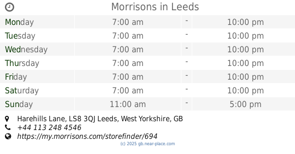
Morrisons
Harehills Lane, Leeds
Supermarket
read more
📑
all categories
Accounting
Administrative area level 1
Administrative area level 2
Airport
Amusement park
Aquarium
Art gallery
Atm
Bakery
Bank
Bar
Beauty salon
Bicycle store
Book store
Bowling alley
Bus station
Cafe
Campground
Car dealer
Car rental
Car repair
Car wash
Casino
Cemetery
Church
City hall
Clothing store
Colloquial area
Convenience store
Courthouse
Dentist
Department store
Doctor
Electrician
Electronics store
Embassy
Establishment
Finance
Fire station
Florist
Food
Funeral home
Furniture store
Gas station
General contractor
Grocery or supermarket
Gym
Hair care
Hardware store
Health
Hindu Temple
Home goods store
Hospital
Insurance agency
Jewelry store
Laundry
Lawyer
Library
Light rail station
Liquor store
Local government office
Locality
Locksmith
Lodging
Meal delivery
Meal takeaway
Mosque
Movie rental
Movie theater
Moving company
Museum
Natural feature
Neighborhood
Night club
Painter
Park
Parking
Pet store
Pharmacy
Physiotherapist
Place of worship
Plumber
Point of interest
Police
Political
Post office
Premise
Real estate agency
Restaurant
Roofing contractor
Route
Rv park, camping
School
Shoe store
Shopping mall
Spa
Stadium
Storage
Store
Subpremise
Subway station
Supermarket
Synagogue
Taxi stand
Train station
Transit station
Travel agency
University
Veterinary care
Zoo
administrative area level 3
administrative area level 4
sublocality level 1
↑