Atm nearby ATM
United Kingdom
Atm nearby ATM
ATM
Northfields, The Old Mill, 30 West Hill Road, Birmingham United Kingdom
contacts phone
:
+44
Latitude:
52.4080882
, Longitude:
-1.9634025
read more
nearest Atm
97 m
co-op cashpoint
18 West Heath Road, Birmingham
Atm
read more
475 m
ATM @ Great Stone Inn
158 Church Road, Birmingham
Atm
read more
625 m
ATM
85 Turves Green, Birmingham
Atm
read more
805 m
ATM (Shell Northfield)
1020 Bristol Road South, Birmingham
Atm
read more
883 m
Sainsbury's ATM
Frankley Beeches Road, Birmingham
Atm
read more
902 m
ATM
798 Bristol Road South, Birmingham
Atm
read more
942 m
ATM (Select And Save Northfield)
78A Ingoldsby Road, Birmingham
Atm
read more
959 m
ATM
1107 Bristol Road South, Birmingham
Atm
read more
983 m
ATM
220-224 Wychall Road, Birmingham
Atm
read more
1.023 km
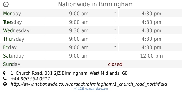
Nationwide
1 Church Road, Birmingham
Atm
read more
1.023 km
Nationwide
1 Church Road, Northfield, Birmingham
Atm
read more
1.349 km
ATM (One Stop Birmingham 0448)
1261 Bristol Road South, Birmingham
Atm
read more
1.715 km
ATM (TZ Stores)
249 Merritt's Brook Lane, Birmingham
Atm
read more
1.849 km
ATM
1401 Bristol Road South, Birmingham
Atm
read more
1.871 km
ATM (Babs Off Licence)
32 Norrington Road, Birmingham
Atm
read more
1.929 km
Sainsbury's Bank ATM
4 High Street, Birmingham
Atm
read more
2.314 km
ATM
79-81 Taysfield Road, Birmingham
Atm
read more
2.437 km
Cashpoint
32 Watford Road, Birmingham
Atm
read more
2.509 km
ATM
1876 Pershore Road, Birmingham
Atm
read more
3.054 km
ATM
47 Sycamore Road, Birmingham
Atm
read more
3.064 km
ATM
Ashbrook Drive, Birmingham
Atm
read more
3.374 km
ATM
1507 Pershore Road, Birmingham
Atm
read more
3.477 km
ATM
1446 Pershore Road, Birmingham
Atm
read more
3.735 km
ATM
Stirchley MIdlands, 4 Hazelwell St, Birmingham, Stirchley
Atm
read more
4.006 km
ATM
1189 Pershore Road, Birmingham
Atm
read more
📑
all categories
Accounting
Administrative area level 1
Administrative area level 2
Airport
Amusement park
Aquarium
Art gallery
Atm
Bakery
Bank
Bar
Beauty salon
Bicycle store
Book store
Bowling alley
Bus station
Cafe
Campground
Car dealer
Car rental
Car repair
Car wash
Casino
Cemetery
Church
City hall
Clothing store
Colloquial area
Convenience store
Courthouse
Dentist
Department store
Doctor
Electrician
Electronics store
Embassy
Establishment
Finance
Fire station
Florist
Food
Funeral home
Furniture store
Gas station
General contractor
Grocery or supermarket
Gym
Hair care
Hardware store
Health
Hindu Temple
Home goods store
Hospital
Insurance agency
Jewelry store
Laundry
Lawyer
Library
Light rail station
Liquor store
Local government office
Locality
Locksmith
Lodging
Meal delivery
Meal takeaway
Mosque
Movie rental
Movie theater
Moving company
Museum
Natural feature
Neighborhood
Night club
Painter
Park
Parking
Pet store
Pharmacy
Physiotherapist
Place of worship
Plumber
Point of interest
Police
Political
Post office
Premise
Real estate agency
Restaurant
Roofing contractor
Route
Rv park, camping
School
Shoe store
Shopping mall
Spa
Stadium
Storage
Store
Subpremise
Subway station
Supermarket
Synagogue
Taxi stand
Train station
Transit station
Travel agency
University
Veterinary care
Zoo
administrative area level 3
administrative area level 4
sublocality level 1
↑