Atm nearby ATM (Old Barn)
United Kingdom
Atm nearby ATM (Old Barn)
ATM (Old Barn)
Secklow Gate West, Milton Keynes United Kingdom
contacts phone
:
+44
Latitude:
52.03974
, Longitude:
-0.75208
read more
nearest Atm
543 m
Nationwide
59 Silbury Boulevard, Milton Keynes
Atm
read more
571 m
ATM
14 Sunset Walk, Milton Keynes
Atm
read more
2.251 km
ATM
19 Farthing Grove, Netherfield, Milton Keynes
Atm
read more
2.421 km
ATM
Japonica Drive, Milton Keynes
Atm
read more
2.877 km
ATM
9 Granville Square, Willen, Milton Keynes
Atm
read more
3.802 km
ATM
Gifford Park, 4 Knebworth Gate, Giffard Park, Milton Keynes
Atm
read more
4.562 km
Cashpoint
2 Elthorne Way, Newport Pagnell
Atm
read more
4.562 km
Bankomat
2 Elthorne Way, Newport Pagnell
Atm
read more
4.563 km
Tesco ATM
Elthorne Way, NEWPORT PAG
Atm
read more
4.749 km
ATM
42 Annesley Road, Newport Pagnell
Atm
read more
4.877 km
ATM
M1 Motorway Southbound Junction 14/15, Newport Pagnell, Milton Keynes
Atm
read more
5.507 km
Cashpoint
2 Vantage Ct, Tickford St Vantage Court, Newport Pagnell
Atm
read more
5.541 km
ATM (BP Chicheley Park Cannon Newport Pagnell)
Tickford Street, Newport Pagnell
Atm
read more
5.546 km
Bankomat
79 High Street, Newport Pagnell
Atm
read more
5.567 km
ATM (Tickford Superstore)
103 Tickford Street, Newport Pagnell
Atm
read more
5.573 km
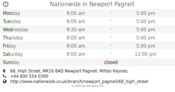
Nationwide
68 High Street, Newport Pagnell
Atm
read more
5.594 km
Lloyd's Bank Cashpoint
7-9 Saint John's Terrace, Newport Pagnell
Atm
read more
5.6 km
ATM
7-9 Saint John Street, Newport Pagnell
Atm
read more
5.669 km
Bankomat Na Poczcie
30-32 High Street, Newport Pagnell
Atm
read more
7.454 km
ATM
Station Road, Woburn Sands, Milton Keynes
Atm
read more
14.661 km
ATM
Station Approach, Leighton Buzzard
Atm
read more
18.362 km
ATM
80 Dunstable Road, Toddington, Dunstable
Atm
read more
23.24 km
ATM
116/118 Saint Leonards Road, Northampton
Atm
read more
25.346 km
ATM
Saint Georges Avenue, Northampton
Atm
read more
26.615 km
ATM
18-20 Newnham Road, Northampton
Atm
read more
📑
all categories
Accounting
Administrative area level 1
Administrative area level 2
Airport
Amusement park
Aquarium
Art gallery
Atm
Bakery
Bank
Bar
Beauty salon
Bicycle store
Book store
Bowling alley
Bus station
Cafe
Campground
Car dealer
Car rental
Car repair
Car wash
Casino
Cemetery
Church
City hall
Clothing store
Colloquial area
Convenience store
Courthouse
Dentist
Department store
Doctor
Electrician
Electronics store
Embassy
Establishment
Finance
Fire station
Florist
Food
Funeral home
Furniture store
Gas station
General contractor
Grocery or supermarket
Gym
Hair care
Hardware store
Health
Hindu Temple
Home goods store
Hospital
Insurance agency
Jewelry store
Laundry
Lawyer
Library
Light rail station
Liquor store
Local government office
Locality
Locksmith
Lodging
Meal delivery
Meal takeaway
Mosque
Movie rental
Movie theater
Moving company
Museum
Natural feature
Neighborhood
Night club
Painter
Park
Parking
Pet store
Pharmacy
Physiotherapist
Place of worship
Plumber
Point of interest
Police
Political
Post office
Premise
Real estate agency
Restaurant
Roofing contractor
Route
Rv park, camping
School
Shoe store
Shopping mall
Spa
Stadium
Storage
Store
Subpremise
Subway station
Supermarket
Synagogue
Taxi stand
Train station
Transit station
Travel agency
University
Veterinary care
Zoo
administrative area level 3
administrative area level 4
sublocality level 1
↑