Atm nearby ATM
United Kingdom
Atm nearby ATM
ATM
York Road, London Det Forenede Kongerige
contacts phone
:
+44
Latitude:
51.4644362
, Longitude:
-0.1822206
read more
nearest Atm
20 m
ATM (Shell Savoy)
262 York Road, London
Atm
read more
293 m
Cash Machine
8a Juniper Dr, London SW18 1TW Juniper Drive, London
Atm
read more
575 m
ATM (Lily Leaf Ltd)
501 Old York Road, London
Atm
read more
729 m
ATM
London Plastercraft Ltd, 314 Wandsworth Bridge Road, London
Atm
read more
812 m
ATM
0 Clapham Road, London
Atm
read more
827 m
ATM
60a Fairfield Street, London
Atm
read more
852 m
ATM (Best One Stores.)
42-46 Fairfield Street, London
Atm
read more
946 m
ATM
23-27 Falcon Road, London
Atm
read more
955 m
Sainsbury's Bank ATM
10 Saint John's Hill, London
Atm
read more
970 m
Admiral Casino: Clapham Junction
Clapham Junction Approach, 1 Saint John's Hill, Clapham Junction
Atm
read more
996 m
Metro ATM
17 Saint John's Road, London
Atm
read more
1.046 km
Sainsbury's Bank ATM
14 Enterprise Way, London
Atm
read more
1.102 km
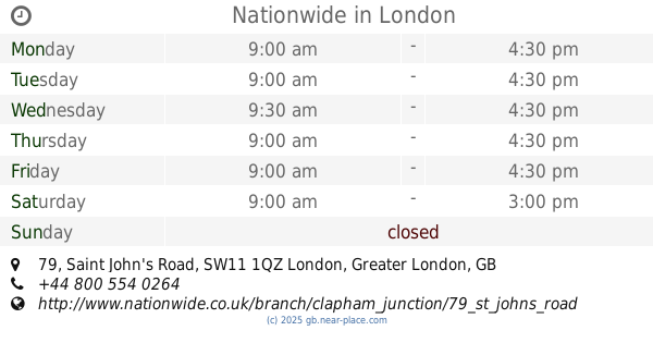
Nationwide
79 St. John's Road, Clapham Junction, Wandsworth, London
Atm
read more
1.102 km
Nationwide
79 Saint John's Road, Clapham Junction, Wandsworth, London
Atm
read more
1.102 km
ATM
326 Battersea Park Road, London
Atm
read more
1.154 km
ATM
83 Wandsworth High Street, London
Atm
read more
1.221 km
ATM
98 Wandsworth High Street, London
Atm
read more
1.224 km
ATM (Convenience)
4 Buckhold Road, London
Atm
read more
1.251 km
ATM
C2-C3, Chelsea Harbour, harbour avwenue, The Chambers, London
Atm
read more
1.272 km
Boost Group
One Hardwick’s Square, Wandsworth, London
Atm
read more
1.282 km
Sainsbury's Bank ATM
Spotted Dog, 72 Garratt Lane, London
Atm
read more
1.356 km
ATM (Savills)
99 Northcote Road, London
Atm
read more
1.603 km
ATM
125 Putney Bridge Road, London
Atm
read more
1.605 km
ATM
Post Office, 179 Garratt Lane, London
Atm
read more
1.874 km
ATM (Tesco)
192 Garrett Lane, Earlsfield, London
Atm
read more
📑
all categories
Accounting
Administrative area level 1
Administrative area level 2
Airport
Amusement park
Aquarium
Art gallery
Atm
Bakery
Bank
Bar
Beauty salon
Bicycle store
Book store
Bowling alley
Bus station
Cafe
Campground
Car dealer
Car rental
Car repair
Car wash
Casino
Cemetery
Church
City hall
Clothing store
Colloquial area
Convenience store
Courthouse
Dentist
Department store
Doctor
Electrician
Electronics store
Embassy
Establishment
Finance
Fire station
Florist
Food
Funeral home
Furniture store
Gas station
General contractor
Grocery or supermarket
Gym
Hair care
Hardware store
Health
Hindu Temple
Home goods store
Hospital
Insurance agency
Jewelry store
Laundry
Lawyer
Library
Light rail station
Liquor store
Local government office
Locality
Locksmith
Lodging
Meal delivery
Meal takeaway
Mosque
Movie rental
Movie theater
Moving company
Museum
Natural feature
Neighborhood
Night club
Painter
Park
Parking
Pet store
Pharmacy
Physiotherapist
Place of worship
Plumber
Point of interest
Police
Political
Post office
Premise
Real estate agency
Restaurant
Roofing contractor
Route
Rv park, camping
School
Shoe store
Shopping mall
Spa
Stadium
Storage
Store
Subpremise
Subway station
Supermarket
Synagogue
Taxi stand
Train station
Transit station
Travel agency
University
Veterinary care
Zoo
administrative area level 3
administrative area level 4
sublocality level 1
↑