Atm nearby Sainsbury's Bank ATM
United Kingdom
Atm nearby Sainsbury's Bank ATM
Sainsbury's Bank ATM
43 Alcester Road South, Birmingham United Kingdom
contacts phone
:
+44
Latitude:
52.4317207
, Longitude:
-1.8926904
read more
nearest Atm
68 m
Nationwide
17-19 Alcester Road South, Birmingham
Atm
read more
89 m
ATM
11 Alcester Road South, Birmingham
Atm
read more
160 m
ATM
159 High Street, Birmingham
Atm
read more
375 m
ATM
96 High Street, Birmingham
Atm
read more
411 m
Barclays ATM
90 High Street, Asda, King's Heath
Atm
read more
567 m
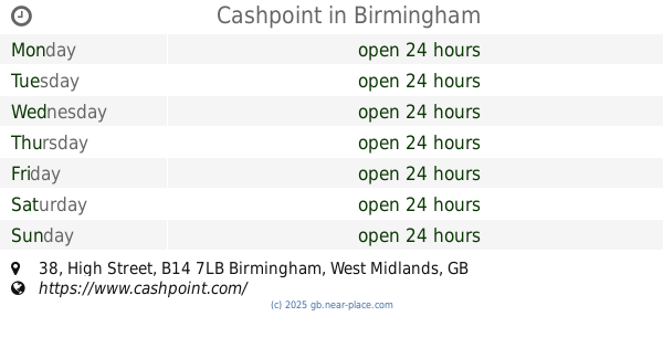
Cashpoint
38 High Street, Birmingham
Atm
read more
590 m
ATM
112-114 Station Road, Birmingham
Atm
read more
659 m
ATM
27 High Street, Birmingham
Atm
read more
786 m
ATM
14 Grove Road, Birmingham
Atm
read more
967 m
ATM (New Billesley)
Brook Lane, Birmingham
Atm
read more
997 m
Co-op ATM
245 Vicarage Road, Birmingham
Atm
read more
1.037 km
ATM
117 Billesley Lane, Birmingham
Atm
read more
1.04 km
ATM
276 Vicarage Road, Birmingham
Atm
read more
1.21 km
ATM
54 Dad's Lane, Birmingham
Atm
read more
1.48 km
ATM
298 Haunch Lane, Birmingham
Atm
read more
1.584 km
Post Office ATM
149 Alcester Road, Birmingham
Atm
read more
1.655 km
ATM
214 Fordhouse Lane, Birmingham
Atm
read more
1.82 km
ATM
1189 Pershore Road, Birmingham
Atm
read more
1.822 km
Co-Op cashpoint
154 Alcester Road, Birmingham
Atm
read more
1.985 km
ATM
Stirchley MIdlands, 4 Hazelwell St, Birmingham, Stirchley
Atm
read more
1.998 km
ATM
619 Alcester Road South, Millpool Hill, Birmingham
Atm
read more
2.056 km
ATM
1446 Pershore Road, Birmingham
Atm
read more
2.118 km
ATM
305 Broad Lane, Birmingham
Atm
read more
2.126 km
ATM
1507 Pershore Road, Birmingham
Atm
read more
2.226 km
ATM
592 Pershore Road, Birmingham
Atm
read more
📑
all categories
Accounting
Administrative area level 1
Administrative area level 2
Airport
Amusement park
Aquarium
Art gallery
Atm
Bakery
Bank
Bar
Beauty salon
Bicycle store
Book store
Bowling alley
Bus station
Cafe
Campground
Car dealer
Car rental
Car repair
Car wash
Casino
Cemetery
Church
City hall
Clothing store
Colloquial area
Convenience store
Courthouse
Dentist
Department store
Doctor
Electrician
Electronics store
Embassy
Establishment
Finance
Fire station
Florist
Food
Funeral home
Furniture store
Gas station
General contractor
Grocery or supermarket
Gym
Hair care
Hardware store
Health
Hindu Temple
Home goods store
Hospital
Insurance agency
Jewelry store
Laundry
Lawyer
Library
Light rail station
Liquor store
Local government office
Locality
Locksmith
Lodging
Meal delivery
Meal takeaway
Mosque
Movie rental
Movie theater
Moving company
Museum
Natural feature
Neighborhood
Night club
Painter
Park
Parking
Pet store
Pharmacy
Physiotherapist
Place of worship
Plumber
Point of interest
Police
Political
Post office
Premise
Real estate agency
Restaurant
Roofing contractor
Route
Rv park, camping
School
Shoe store
Shopping mall
Spa
Stadium
Storage
Store
Subpremise
Subway station
Supermarket
Synagogue
Taxi stand
Train station
Transit station
Travel agency
University
Veterinary care
Zoo
administrative area level 3
administrative area level 4
sublocality level 1
↑