Atm nearby Throgmorton UK Ltd
United Kingdom
Atm nearby Throgmorton UK Ltd
Throgmorton UK Ltd
33 Saint James's Square, London Det Forenede Kongerige
contacts phone
:
+44
Latitude:
51.50731
, Longitude:
-0.1341694
read more
nearest Atm
247 m
Bankomat
35 Regent St St. James's London SW1Y 4ND Regent Street, London
Atm
read more
248 m
ATM RBS
Jermyn Street, London
Atm
read more
274 m
HSBC ATM
69 Pall Mall, London
Atm
read more
340 m
Barclays Bank
Piccadilly Circus, London
Atm
read more
447 m
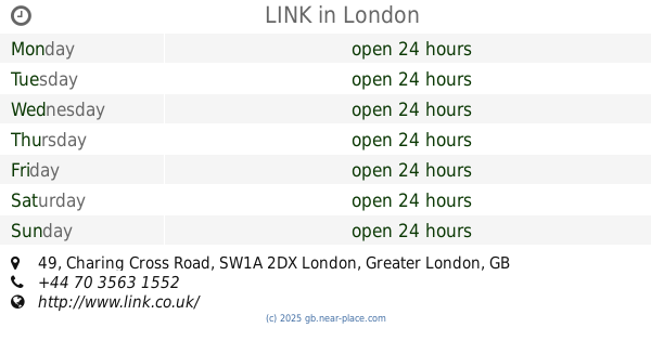
LINK
49 Charing Cross Road, London
Atm
read more
473 m
SatoshiPoint BitcoinATM, Marvel Cars / Snack Shop
4 Lisle Street, Piccadilly, London
Atm
read more
556 m
ATM
372 / 456-458 Strand،London
Atm
read more
581 m
QH
house old Burlington Street, Queensbury
Atm
read more
586 m
Halifax ATM
51 Berkeley Street, London
Atm
read more
613 m
LJ Partnership
10 Old Burlington Street, London
Atm
read more
651 m
Sainsbury's Bank ATM
50 Berkeley Street, London
Atm
read more
669 m
ATM Cash Machine
Broadwick Street, London
Atm
read more
716 m
ATM
38 Strand،London WC2N، 5JB،
Atm
read more
725 m
Best Foreign Exchange
3 Villers Street, London
Atm
read more
743 m
Greenhill
Landsdowne House, 57 Berkeley Square, London
Atm
read more
766 m
ATM (Changegroup Charing Cross Road)
95 Charing Cross Road, London
Atm
read more
767 m
ATM Halifax
55 Strand, London
Atm
read more
784 m
HSBC ATM
16 King Sreet, London
Atm
read more
832 m
ATM Nationwide
415 Strand, London
Atm
read more
852 m
Barclays ATM
London
Atm
read more
1.011 km
ATM
366 Strand, London
Atm
read more
1.016 km
HSBC
Oxford Circus, 196 Oxford Street, London
Atm
read more
1.035 km
ATM Cashpoint
24 Market Place, London
Atm
read more
1.09 km
ATM (Mayfair Post Office)
32A Grosvenor Street, London
Atm
read more
1.128 km
ATM (Explorer)
23 Great Castle Street, London
Atm
read more
📑
all categories
Accounting
Administrative area level 1
Administrative area level 2
Airport
Amusement park
Aquarium
Art gallery
Atm
Bakery
Bank
Bar
Beauty salon
Bicycle store
Book store
Bowling alley
Bus station
Cafe
Campground
Car dealer
Car rental
Car repair
Car wash
Casino
Cemetery
Church
City hall
Clothing store
Colloquial area
Convenience store
Courthouse
Dentist
Department store
Doctor
Electrician
Electronics store
Embassy
Establishment
Finance
Fire station
Florist
Food
Funeral home
Furniture store
Gas station
General contractor
Grocery or supermarket
Gym
Hair care
Hardware store
Health
Hindu Temple
Home goods store
Hospital
Insurance agency
Jewelry store
Laundry
Lawyer
Library
Light rail station
Liquor store
Local government office
Locality
Locksmith
Lodging
Meal delivery
Meal takeaway
Mosque
Movie rental
Movie theater
Moving company
Museum
Natural feature
Neighborhood
Night club
Painter
Park
Parking
Pet store
Pharmacy
Physiotherapist
Place of worship
Plumber
Point of interest
Police
Political
Post office
Premise
Real estate agency
Restaurant
Roofing contractor
Route
Rv park, camping
School
Shoe store
Shopping mall
Spa
Stadium
Storage
Store
Subpremise
Subway station
Supermarket
Synagogue
Taxi stand
Train station
Transit station
Travel agency
University
Veterinary care
Zoo
administrative area level 3
administrative area level 4
sublocality level 1
↑