Bakery nearby Betty's
Coronavirus disease (COVID-19) Situation
confirmed cases
24910387
deaths
232112
United Kingdom
Bakery nearby Betty's
Betty's
272 Belsize Road, London United Kingdom
contacts phone
:
+44
Latitude:
51.5375932
, Longitude:
-0.1923119
read more
nearest Bakery
243 m
Wenzel's the Bakers
106A Kilburn High Road, London
Bakery
read more
471 m
Bake & Cake
178 Kilburn High Road, London
Bakery
read more
1.138 km
Bay Bakeries
203 Shirland Road, London
Bakery
read more
1.138 km
Tregeser
203 Shirland Road, London
Bakery
read more
1.142 km
Wenzel’s the Bakers
148 West End Lane, London
Bakery
read more
1.276 km
Lanka
9 Goldhurst Terrace, London
Bakery
read more
1.415 km
Ripa's Cakes
38B Walterton Road, London
Bakery
read more
1.491 km
GAIL's Bakery St Johns Wood
5 Circus Road, London
Bakery
read more
1.534 km
The Bread Shop Co
65 Saint John's Wood High Street, London
Bakery
read more
1.589 km
Wenzel’s the Bakers
272 West End Lane, London
Bakery
read more
1.592 km
Baker & Spice
20 Clifton Rd, London
Bakery
read more
1.592 km
Baker & Spice
20 Clifton Road, London
Bakery
read more
1.609 km
kado
376 Harrow Road, London
Bakery
read more
1.622 km
La Maison du Gateau
367 Harrow Road, London
Bakery
read more
1.861 km
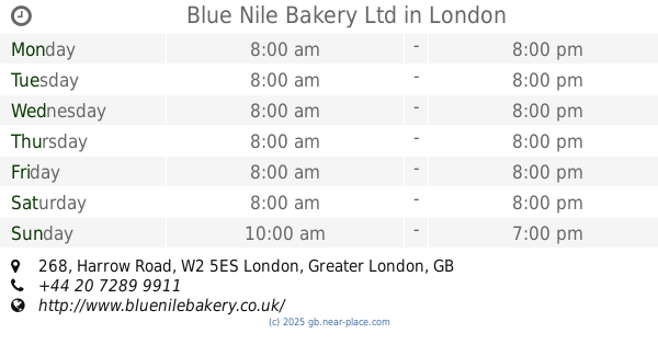
Blue Nile Bakery Ltd
268 Harrow Road, London
Bakery
read more
1.938 km
Delicious Bakery
7 Kilburn Lane, London
Bakery
read more
2.084 km
L'Étoile de Sous
79 Golborne Road, London
Bakery
read more
2.35 km
Ronis Bakery - Hampstead
44 Rosslyn Hill, London
Bakery
read more
2.354 km
Euphorium Bakery
211 Haverstock Hill, London
Bakery
read more
2.357 km
GAIL's Bakery Belsize Park
167 Haverstock Hill, London
Bakery
read more
2.376 km
Cricklewood Bagel Bakery
92 Cricklewood Broadway, London
Bakery
read more
2.399 km
Italian on the Edge
328 Edgware Road, London
Bakery
read more
2.617 km
Karma Bread Bakehouse
13 South End Road, London
Bakery
read more
2.657 km
Euphorium Bakery
Hampstead Heath Railway Station, 45 South End Road, London
Bakery
read more
3.575 km
Justin de Blanc
120 Marylebone Lane, London
Bakery
read more
📑
all categories
Accounting
Administrative area level 1
Administrative area level 2
Airport
Amusement park
Aquarium
Art gallery
Atm
Bakery
Bank
Bar
Beauty salon
Bicycle store
Book store
Bowling alley
Bus station
Cafe
Campground
Car dealer
Car rental
Car repair
Car wash
Casino
Cemetery
Church
City hall
Clothing store
Colloquial area
Convenience store
Courthouse
Dentist
Department store
Doctor
Electrician
Electronics store
Embassy
Establishment
Finance
Fire station
Florist
Food
Funeral home
Furniture store
Gas station
General contractor
Grocery or supermarket
Gym
Hair care
Hardware store
Health
Hindu Temple
Home goods store
Hospital
Insurance agency
Jewelry store
Laundry
Lawyer
Library
Light rail station
Liquor store
Local government office
Locality
Locksmith
Lodging
Meal delivery
Meal takeaway
Mosque
Movie rental
Movie theater
Moving company
Museum
Natural feature
Neighborhood
Night club
Painter
Park
Parking
Pet store
Pharmacy
Physiotherapist
Place of worship
Plumber
Point of interest
Police
Political
Post office
Premise
Real estate agency
Restaurant
Roofing contractor
Route
Rv park, camping
School
Shoe store
Shopping mall
Spa
Stadium
Storage
Store
Subpremise
Subway station
Supermarket
Synagogue
Taxi stand
Train station
Transit station
Travel agency
University
Veterinary care
Zoo
administrative area level 3
administrative area level 4
sublocality level 1
↑