Bakery nearby Party Planet
Coronavirus disease (COVID-19) Situation
confirmed cases
24910387
deaths
232112
United Kingdom
Bakery nearby Party Planet
Party Planet
1a, Jubilee Avenue, Liverpool Zjednoczone Królestwo
contacts phone
:
+44
Latitude:
53.4069985
, Longitude:
-2.8931728
read more
nearest Bakery
477 m
Clare Nicholas Cake Design
Christopher Way, Liverpool
Bakery
read more
1.279 km
Just The Cupcake Co
22 Abbeystead Road, Liverpool
Bakery
read more
1.366 km
Tom Williams Cake Factory
29 Broad Green Road, Liverpool
Bakery
read more
1.394 km
Poundbakery
569 Prescot Road, Liverpool
Bakery
read more
1.419 km
Greenhalgh's
559 Prescot Road, Liverpool
Bakery
read more
1.553 km
Sayers
7-7A Childwall Lane, Liverpool
Bakery
read more
1.65 km
Sayers
365 Eaton Road, Liverpool
Bakery
read more
1.721 km
Sayers
9 Dovecot Place, Liverpool
Bakery
read more
1.845 km
Let Em Eat Cake Liverpool
24 Merton Close, Liverpool
Bakery
read more
1.969 km
Licky Lips Cakes
2 Beechburn Crescent, Huyton, Liverpool
Bakery
read more
2.033 km
Centre Attraction Cakes 2 Remember
436 Prescot Road, Liverpool
Bakery
read more
2.033 km
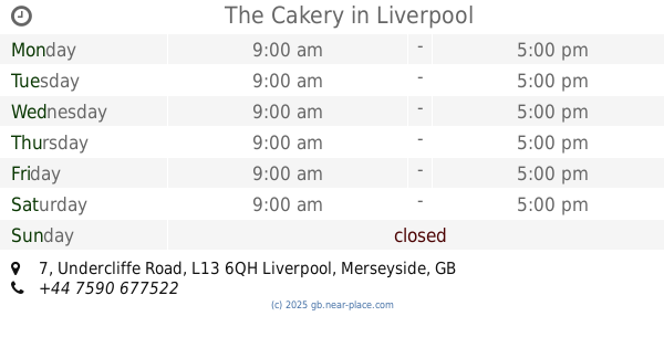
The Cakery
7 Undercliffe Road, Liverpool
Bakery
read more
2.054 km
Renshaw Academy
61 Stephenson Way, Wavertree Tech Park, Liverpool
Bakery
read more
2.547 km
Sayers
152 Allerton Road, Liverpool
Bakery
read more
2.687 km
Cakes by Jean
18 Cockshead Way, Liverpool
Bakery
read more
2.69 km
L'oven Cake
296 Smithdown Road, Liverpool
Bakery
read more
2.864 km
Sayers
17C Belle Vale Shopping Centre Liverpool L25 2RF
Bakery
read more
2.883 km
Cakes Galore
41 Mill Lane, Liverpool
Bakery
read more
2.895 km
Rough Hand Made
38 Penny Lane, Liverpool
Bakery
read more
2.968 km
Dafna's Cheese Cake Factory
240 Smithdown Road, Sefton, Liverpool
Bakery
read more
2.988 km
Laura's Little Bakery
unit 5, 198 Edge Lane, Liverpool
Bakery
read more
3.007 km
Sayers
47 Lawrence Road, Liverpool
Bakery
read more
3.021 km
Hilary's Cupcakes Liverpool
Beaconsfield Road, Liverpool
Bakery
read more
3.273 km
Cuckoo cakes
New Road, Liverpool
Bakery
read more
3.383 km
Angel's Bake
8 Westcliffe Road, Liverpool
Bakery
read more
📑
all categories
Accounting
Administrative area level 1
Administrative area level 2
Airport
Amusement park
Aquarium
Art gallery
Atm
Bakery
Bank
Bar
Beauty salon
Bicycle store
Book store
Bowling alley
Bus station
Cafe
Campground
Car dealer
Car rental
Car repair
Car wash
Casino
Cemetery
Church
City hall
Clothing store
Colloquial area
Convenience store
Courthouse
Dentist
Department store
Doctor
Electrician
Electronics store
Embassy
Establishment
Finance
Fire station
Florist
Food
Funeral home
Furniture store
Gas station
General contractor
Grocery or supermarket
Gym
Hair care
Hardware store
Health
Hindu Temple
Home goods store
Hospital
Insurance agency
Jewelry store
Laundry
Lawyer
Library
Light rail station
Liquor store
Local government office
Locality
Locksmith
Lodging
Meal delivery
Meal takeaway
Mosque
Movie rental
Movie theater
Moving company
Museum
Natural feature
Neighborhood
Night club
Painter
Park
Parking
Pet store
Pharmacy
Physiotherapist
Place of worship
Plumber
Point of interest
Police
Political
Post office
Premise
Real estate agency
Restaurant
Roofing contractor
Route
Rv park, camping
School
Shoe store
Shopping mall
Spa
Stadium
Storage
Store
Subpremise
Subway station
Supermarket
Synagogue
Taxi stand
Train station
Transit station
Travel agency
University
Veterinary care
Zoo
administrative area level 3
administrative area level 4
sublocality level 1
↑