Bakery nearby The Oatcake Boat
United Kingdom
Bakery nearby The Oatcake Boat
The Oatcake Boat
Etruria, Stoke-on-Trent Reino Unido
contacts phone
:
+44
Latitude:
53.024482
, Longitude:
-2.1969629
read more
nearest Bakery
1.122 km
Ariana Mini Market and Bakery
24 Snow Hill, Stoke-on-Trent
Bakery
read more
1.268 km
Tsp Cake
84 Piccadilly, Stoke-on-Trent
Bakery
read more
1.472 km
Baskin-Robbins & Millie's Cookies
Unit 124A (level 3) Pottery Shopping Centre, Hanley
Bakery
read more
1.477 km
Thorntons
26 Tontine Street, Stoke-on-Trent
Bakery
read more
1.478 km
Wrights
8 Tontine Street, Stoke-on-Trent
Bakery
read more
1.495 km
Krispy Kreme
Midmall, Quadrant Road, Stoke-on-Trent
Bakery
read more
1.495 km
Krispy Kreme
intu Potteries, Midmall, Quadrant Road, Stoke-on-Trent
Bakery
read more
1.497 km
Dolly Train Event and Celebration Cakes
1 Minton Street, Newcastle
Bakery
read more
1.521 km
Poundbakery
12 Parliament Row, Stoke-on-Trent
Bakery
read more
1.568 km
Wright's Pies Ltd
1 Ellison Street, Newcastle
Bakery
read more
1.629 km
Annie's Cakes of Art
115 High Street, Newcastle
Bakery
read more
1.841 km
Nafees Bakers & Sweets Stoke on Trent
113-115 College Road, Stoke-on-Trent
Bakery
read more
1.848 km
Sophie's Cake Creations
Hanley, Stoke-on-Trent
Bakery
read more
1.865 km
Wrights
College Road, Stoke-on-Trent
Bakery
read more
1.895 km
Zeen Naan Bakery
78 Ashford Street, Stoke-on-Trent
Bakery
read more
2.192 km
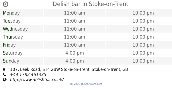
Delish bar
107 Leek Road, Stoke-on-Trent
Bakery
read more
2.207 km
Porthill Pantry
155A Watlands View, Newcastle
Bakery
read more
2.376 km
Poundbakery
5 Castle Walk, Newcastle
Bakery
read more
2.51 km
Hello Sweetie Cupcakery
11, York Place, Newcastle
Bakery
read more
2.515 km
My Little Cupcakery
6 Harrison Street, Newcastle
Bakery
read more
2.576 km
Chatwins
34 High Street, Newcastle
Bakery
read more
2.597 km
Busy Bee
6 The Midway, Newcastle
Bakery
read more
2.611 km
Castle Oatcakes
78 London Road, Newcastle
Bakery
read more
2.777 km
Petes
20 Oakdene Avenue, Newcastle
Bakery
read more
2.783 km
Allied Bakeries
Liverpool Road, Newcastle-under-Lyme, Newcastle
Bakery
read more
📑
all categories
Accounting
Administrative area level 1
Administrative area level 2
Airport
Amusement park
Aquarium
Art gallery
Atm
Bakery
Bank
Bar
Beauty salon
Bicycle store
Book store
Bowling alley
Bus station
Cafe
Campground
Car dealer
Car rental
Car repair
Car wash
Casino
Cemetery
Church
City hall
Clothing store
Colloquial area
Convenience store
Courthouse
Dentist
Department store
Doctor
Electrician
Electronics store
Embassy
Establishment
Finance
Fire station
Florist
Food
Funeral home
Furniture store
Gas station
General contractor
Grocery or supermarket
Gym
Hair care
Hardware store
Health
Hindu Temple
Home goods store
Hospital
Insurance agency
Jewelry store
Laundry
Lawyer
Library
Light rail station
Liquor store
Local government office
Locality
Locksmith
Lodging
Meal delivery
Meal takeaway
Mosque
Movie rental
Movie theater
Moving company
Museum
Natural feature
Neighborhood
Night club
Painter
Park
Parking
Pet store
Pharmacy
Physiotherapist
Place of worship
Plumber
Point of interest
Police
Political
Post office
Premise
Real estate agency
Restaurant
Roofing contractor
Route
Rv park, camping
School
Shoe store
Shopping mall
Spa
Stadium
Storage
Store
Subpremise
Subway station
Supermarket
Synagogue
Taxi stand
Train station
Transit station
Travel agency
University
Veterinary care
Zoo
administrative area level 3
administrative area level 4
sublocality level 1
↑