Bank nearby Handelsbanken Leeds Wellington Street
Coronavirus disease (COVID-19) Situation
confirmed cases
24910387
deaths
232112
United Kingdom
Bank nearby Handelsbanken Leeds Wellington Street
Handelsbanken Leeds Wellington Street
9th Floor WestOne, 114 Wellington Street, Leeds United Kingdom
contacts phone
:
+44
Latitude:
53.7969239
, Longitude:
-1.5567432
read more
nearest Bank
41 m
Lloyds Bank Commercial Finance
116 Wellington Street, Leeds
Bank
read more
41 m
Lloyds Bank
Lisbon House, 3, 116 Wellington Street, Leeds
Bank
read more
60 m
Lloyds Bank Commercial Finance
Lisbon House, 3, 116 Wellington Street, Leeds
Bank
read more
95 m
Brown Shipley
10 Wellington Place, Leeds
Bank
read more
272 m
Rothschild Global Advisory
1 Park Lane, Leeds
Bank
read more
613 m
Allied Irish Bank (GB)
1 City Square, Leeds
Bank
read more
632 m
HSBC
33 Park Row, Leeds
Bank
read more
655 m
RBS
27 Park Row, Leeds
Bank
read more
659 m
Rothschild N M & Sons Ltd
1 Park Row, Leeds
Bank
read more
660 m
Santander
10 Park Row, Leeds
Bank
read more
666 m
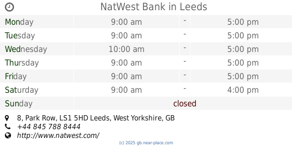
NatWest Bank
8 Park Row, Leeds
Bank
read more
717 m
TSB Bank
119 The Headrow, Leeds
Bank
read more
765 m
Barclays Bank
69 Albion Street, Leeds
Bank
read more
808 m
The Co-operative Bank - Leeds
19/20 Commercial Street, Leeds
Bank
read more
828 m
Halifax
32 Commercial Street, Leeds
Bank
read more
874 m
Bank Fashion
Msu1, The Core Shopping Centre, Leeds
Bank
read more
889 m
Yorkshire Bank
20 Lands Lane, Leeds
Bank
read more
894 m
Handelsbanken Leeds, The Embankment
The Embankment, 3, Sovereign Street, Leeds
Bank
read more
936 m
Virgin Money
51 Briggate, Leeds
Bank
read more
936 m
Santander
58-60 Briggate, Leeds
Bank
read more
944 m
Lloyds Bank
65-68 Briggate, Leeds
Bank
read more
964 m
M&S Bank Leeds
47 Briggate, Leeds
Bank
read more
996 m
Yorkshire Bank
94-96 Briggate, Leeds
Bank
read more
1.054 km
Santander
Merrion Street, Leeds
Bank
read more
1.131 km
ATM
Clay Pit Lane, Leeds
Bank
read more
📑
all categories
Accounting
Administrative area level 1
Administrative area level 2
Airport
Amusement park
Aquarium
Art gallery
Atm
Bakery
Bank
Bar
Beauty salon
Bicycle store
Book store
Bowling alley
Bus station
Cafe
Campground
Car dealer
Car rental
Car repair
Car wash
Casino
Cemetery
Church
City hall
Clothing store
Colloquial area
Convenience store
Courthouse
Dentist
Department store
Doctor
Electrician
Electronics store
Embassy
Establishment
Finance
Fire station
Florist
Food
Funeral home
Furniture store
Gas station
General contractor
Grocery or supermarket
Gym
Hair care
Hardware store
Health
Hindu Temple
Home goods store
Hospital
Insurance agency
Jewelry store
Laundry
Lawyer
Library
Light rail station
Liquor store
Local government office
Locality
Locksmith
Lodging
Meal delivery
Meal takeaway
Mosque
Movie rental
Movie theater
Moving company
Museum
Natural feature
Neighborhood
Night club
Painter
Park
Parking
Pet store
Pharmacy
Physiotherapist
Place of worship
Plumber
Point of interest
Police
Political
Post office
Premise
Real estate agency
Restaurant
Roofing contractor
Route
Rv park, camping
School
Shoe store
Shopping mall
Spa
Stadium
Storage
Store
Subpremise
Subway station
Supermarket
Synagogue
Taxi stand
Train station
Transit station
Travel agency
University
Veterinary care
Zoo
administrative area level 3
administrative area level 4
sublocality level 1
↑